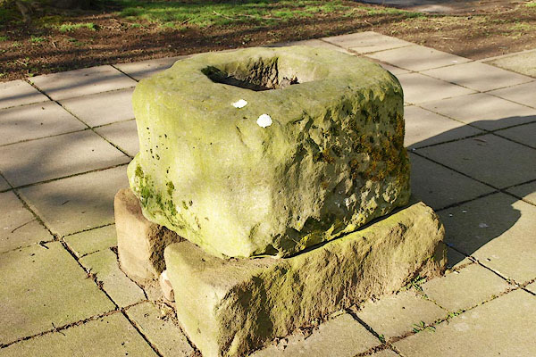


BQF15.jpg (taken 6.3.2009)
placename:- Plague Stone
item:- cross
 goto source
Page 14:- "..."
"Nearly half way between Emont Bridge and Penrith stands an house, called from its situation Halfway-House, ..."
"During the dreadful plague which visited this country in the year 1598, and almost depopulated Penrith, (no less than 2260 in the town falling victims to this merciless disease,) the Millers and Villagers refused to bring their commodities into the town to market for fear of the infection. The inhabitants, therefore were under the necessity of meeting them here [Halfway House], and performing a kind of quarantine before they were allowed to buy any thing; and for this purpose they erected a cross, which remains to this day. For greater conveniences, they likewise built another cross at the town's-head, and erected shambles, &c.; the place still retains the name of Cross-Green: they built a third cross near the Carlisle road a little above the second, where black cattle, sheep, hogs and goats were sold; and it retains yet the name of the Nolt-Fair, and continues to be the market for cattle. QUOTE3 ..."
item:- cross; plague stone
A cross base, not a plague stone? "The Plague-stone at Penrith is a block weighing about a ton, of stone, so Mr. George Watson says, from the Lazonby district; roughly squared, and with a large hollow in the upper surface. In times of plague the hole was filled with vinegar, into which people from infected houses put their money, and retired to a distance, while the tradesfolk came and laid their goods beside the stone, taking the money out of the vinegar, which was thought to clear it of infection. But the hole was not made for this purpose, and the stone seems to have been the base of a cross."
placename:- Plague Stone
HP01p135.txt
Page 135:- "Penrith has suffered much in its time from wars and tumults, but it was afflicted in a dreadful manner by a great plague which almost depopulated the neighbourhood between September, 1597, and January, 1599, as an inscription in the church relates. In Penrith itself 2,260 people died, and in Kendal, 2,500."
"The "Plague Stone" still remains, half a mile from the town, in the midst of a field. It has a deep hole, into which the townsfolk, coming out of the town to receive provisions which the timid farmers had deposited there, placed the money for payment, the hole being filled with vinegar as a disinfectant."
courtesy of English Heritage
"PLAGUE STONE IN GROUNDS OF GREENGARTH OLD PEOPLE'S HOME / / BRIDGE LANE / PENRITH / EDEN / CUMBRIA / II[star] / 72789 / NY5196329563"
courtesy of English Heritage
"Possibly an old cross base, placed near Eamont Bridge near the entry to the town in 1598 and used for transfer of coin between town and country people. Now used as a sculptural feature. A whinstone block 2 ft 6 ins x 2 ft O ins x 1 ft 6 ins with stopped chamfer at angles and square recess in top."
