 Old Cumbria Gazetteer
 |
 |
|
| New Inn, Brough | ||
| New Inn | ||
| locality:- | Brough | |
| civil parish:- | Brough (formerly Westmorland) | |
| county:- | Cumbria | |
| locality type:- | inn | |
| coordinates:- | NY80251487 (guess) | |
| 1Km square:- | NY8014 | |
| 10Km square:- | NY81 | |
| references:- | Wallis 1810 |
|
|
|
||
| evidence:- | road book:- Cary 1798 (2nd edn 1802) placename:- New Inn |
|
| source data:- | Road book, itineraries, Cary's New Itinerary, by John Cary, 181
Strand, London, 2nd edn 1802. goto source goto source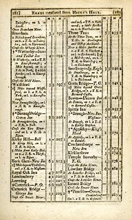 click to enlarge click to enlargeC38281.jpg page 281-282 "Brough - New Inn, Westmor." goto source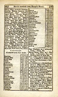 click to enlarge click to enlargeC38285.jpg page 285-286 "INNS. ... Brough, New Inn, Swan. ..." goto source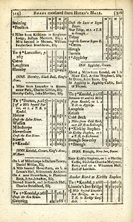 click to enlarge click to enlargeC38315.jpg page 315-316 "INNS. Brough, New Inn, Swan." item:- JandMN : 228.1 Image © see bottom of page |
|
|
|
||
| evidence:- | descriptive text:- Wallis 1810 placename:- New Inn |
|
| source data:- | Map, Westmoreland, scale about 19 miles to 1 inch, and
Cumberland, scale about 16 miles to 1 inch, by James Wallis, 77
Berwick Street, Soho, London, 1810; published 1810-36. "PRINCIPAL INNS, RECOMMENDED TO TRAVELLERS AND FAMILIES." "Brough: Swan, Black Bull, Fleece, New Inn." |
|
|
|
||
| evidence:- | old map:- Wallis 1810 (Wmd) placename:- New Inn |
|
| source data:- | Road map, Westmoreland, scale about 19 miles to 1 inch, by James
Wallis, 77 Berwick Street, Soho, 1810, published by W Lewis,
Finch Lane, London, 1835? click to enlarge click to enlargeWAL5.jpg "New Inn" inn item:- JandMN : 63 Image © see bottom of page |
|
|
|
||
| evidence:- | possibly old map:- Hall 1820 (Wmd) placename:- New Inn |
|
| source data:- | Map, hand coloured engraving, Westmoreland ie Westmorland, scale
about 14.5 miles to 1 inch, by Sidney Hall, London, 1820,
published by Samuel Leigh, 18 Strand, London, 1820-31. click to enlarge click to enlargeHA18.jpg "New Inn" circle; inn item:- Armitt Library : 2008.14.58 Image © see bottom of page |
|
|
|
||
Lakes Guides menu.