 Old Cumbria Gazetteer
 |
 |
|
||||||||||||||||||
| road, Gosforth to Wasdale Head | ||||||||||||||||||||
| Gosforth to Wasdale Head | ||||||||||||||||||||
| Wasdale Head to Gosforth | ||||||||||||||||||||
| civil parish:- | Gosforth (formerly Cumberland) | |||||||||||||||||||
| civil parish:- | Nether Wasdale (formerly Cumberland) | |||||||||||||||||||
| county:- | Cumbria | |||||||||||||||||||
| locality type:- | route | |||||||||||||||||||
| 10Km square:- | NY10 | |||||||||||||||||||
|
|
||||||||||||||||||||
| evidence:- | old print:- Wilkinson 1810 (plate 41) |
|||||||||||||||||||
| source data:- | Print, uncoloured soft ground etching, Wast Water, looking up to Wastdale Head, Cumberland,
by Joseph Wilkinson, engraved by William Frederick Wells, published by R Ackermann,
Repository of Arts, 101 Strand, London, 1810.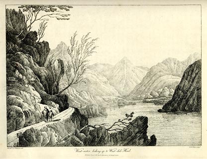 click to enlarge click to enlargeWKN141.jpg Plate 41 in Select Views in Cumberland, Westmoreland, and Lancashire. printed at bottom left, right, centre:- "The Revd. Jos: Wilkenson delt. / W. F. Wells sculpt. / Wast-water, looking up to Wast-dale Head. / Published June 1. 1810. by R. Ackermann. 101. Strand. London." item:- Fell and Rock Climbing Club : MN4.41 Image © see bottom of page |
|||||||||||||||||||
|
|
||||||||||||||||||||
| evidence:- | old print:- Green 1814 (plate 44) |
|||||||||||||||||||
| source data:- | Print, uncoloured soft ground etching, Wast Water from the Road, Nether Wasdale, Cumberland,
by William Green, Ambleside, Westmorland, 1814.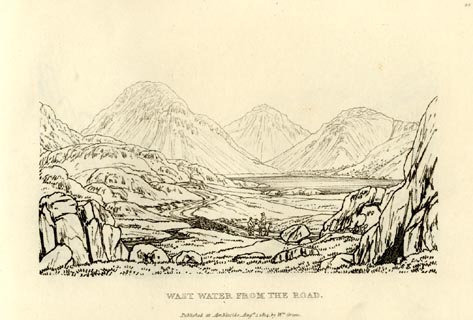 click to enlarge click to enlargeGN0944.jpg Plate 44 in Sixty Small Prints. printed at top right:- "44" printed at bottom:- "WAST WATER FROM THE ROAD. / Published at Ambleside Augst. 1, 1814, by Wm. Green." item:- Armitt Library : A6656.44 Image © see bottom of page |
|||||||||||||||||||
|
|
||||||||||||||||||||
| evidence:- | old print:- Green 1814 (plate 44) |
|||||||||||||||||||
| source data:- | Print, tinted soft ground etching, Wast Water from the Road, Nether Wasdale, Cumberland,
by William Green, Ambleside, Westmorland, 1814.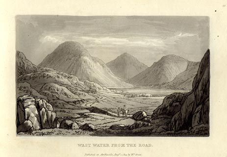 click to enlarge click to enlargeGN1044.jpg Plate 44 in Sixty Small Prints. printed at top right:- "44" printed at bottom:- "WAST WATER FROM THE ROAD. / Published at Ambleside Augst. 1, 1814, by Wm. Green." item:- Armitt Library : A6653.44 Image © see bottom of page |
|||||||||||||||||||
|
|
||||||||||||||||||||
| evidence:- | old map:- Hall 1820 (Cmd) |
|||||||||||||||||||
| source data:- | Map, hand coloured engraving, Cumberland, scale about 21 miles
to 1 inch, engraved by Sidney Hall, published by S Leigh, 18
Strand, London, 1820-31. click to enlarge click to enlargeHA14.jpg single line, solid; minor road; Gosforth, Wood How, Wasdale Head item:- JandMN : 91 Image © see bottom of page |
|||||||||||||||||||
|
|
||||||||||||||||||||
| evidence:- | descriptive text:- Otley 1823 (5th edn 1834) item:- viewpoint; road distances; itinerary |
|||||||||||||||||||
| source data:- | Guide book, A Concise Description of the English Lakes, the
mountains in their vicinity, and the roads by which they may be
visited, with remarks on the mineralogy and geology of the
district, by Jonathan Otley, published by the author, Keswick,
Cumberland now Cumbria, by J Richardson, London, and by Arthur
Foster, Kirkby Lonsdale, Cumbria, 1823; published 1823-49,
latterly as the Descriptive Guide to the English Lakes. goto source goto sourcePage 129:- "KESWICK TO WAST WATER." goto sourcePage 131:- "After passing the inhabited part of the valley [Wadale Head], the road approaches the lake, which shews the purity of its water, by the clean blue gravel washed upon its shores. As the road proceeds along the margin of the lake, the screes on the opposite side form a striking object, and the mountains left behind should not be forgotten; retrospective views taken at short intervals, will shew the majestic and varied forms they assume on being viewed from different points. After passing Over Beck Bridge at the foot of Bowderdale, and just before entering the gate, the mountain Yewbarrow appears in a fine conical shape: and one of the best views of the lake is from a rocky knoll projecting into the water." "It has been suggested that Wast Water would be more advantageously seen, by reversing the excursion, so that the principal mountain views would be always in prospect on advancing up the vale. As far as relates to Wast Water alone, this is certainly true; but ... tourists generally congratulate themselves, on having passed over the most difficult part of the road on the first day." "Towards the lower parts of the lake, the shores are more rocky; and the composition of the rock is changed, from a kind of greenstone, to a reddish sienite. ..." goto sourcePage 132:- "A road turns off on the left to Ravenglass; and at the Strands, near the Church, there are two small public-houses, at one of which it may be necessary to take some refreshment, after a morning's ride of 20 miles, and none of the best road."
|
|||||||||||||||||||
|
|
||||||||||||||||||||
| evidence:- | old strip map:- Rumney 1899 |
|||||||||||||||||||
| source data:- | Road map, strip map and itinerary for Route XVII, Seascale to Wastdale Head, Cumberland,
scale about 2 miles to 1 inch, by A W Rumney, published by George Philip and Son,
32 Fleet Street, London, and Liverpool, 1899.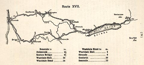 click to enlarge click to enlargeRUM124.jpg On p.70 of the Cyclist's Guide to the English Lake District, by A W Rumney. printed at top:- "Route XVII." item:- JandMN : 147.25 Image © see bottom of page |
|||||||||||||||||||
|
|
||||||||||||||||||||
| places:- | Gosforth Nether Wasdale Wasdale Head, Nether Wasdale |
|||||||||||||||||||
|
|
||||||||||||||||||||
Lakes Guides menu.