 Old Cumbria Gazetteer
 |
 |
|
| Brathay Quarries, Skelwith | ||
| Brathay Quarries | ||
| site name:- | Great Brathay | |
| locality:- | Brathay (?) | |
| civil parish:- | Skelwith (formerly Lancashire) | |
| county:- | Cumbria | |
| locality type:- | slate quarry | |
| locality type:- | quarry | |
| coordinates:- | NY35780161 (etc) | |
| 1Km square:- | NY3501 | |
| 10Km square:- | NY30 | |
|
|
||
| evidence:- | old map:- OS County Series (Lan 2 6) placename:- Brathay Quarries |
|
| source data:- | Maps, County Series maps of Great Britain, scales 6 and 25
inches to 1 mile, published by the Ordnance Survey, Southampton,
Hampshire, from about 1863 to 1948. |
|
|
|
||
| evidence:- | descriptive text:- Otley 1823 (5th edn 1834) item:- geology; gravestone |
|
| source data:- | Guide book, A Concise Description of the English Lakes, the
mountains in their vicinity, and the roads by which they may be
visited, with remarks on the mineralogy and geology of the
district, by Jonathan Otley, published by the author, Keswick,
Cumberland now Cumbria, by J Richardson, London, and by Arthur
Foster, Kirkby Lonsdale, Cumbria, 1823; published 1823-49,
latterly as the Descriptive Guide to the English Lakes. goto source goto sourcePage 159:- "... A quarry one mile from Brathay on the road towards Hawkshead, yields excellent flags for flooring; and they are manufactured into tombstones with good effect, by Mr. Webster of Kendal, and by Mr. Bromley of Keswick. This quarry affords a good example of the stratification (or, as some will have it, the rhomboidal crystallization) of these rocks. The cleavage is here nearly perpendicular; and the strata, being from one foot to five in thickness, dip to the south-east at an angle of about thirty degrees. ..." |
|
|
|
||
| evidence:- | probably old map:- Ford 1839 map placename:- Flag Quarry |
|
| source data:- | Map, uncoloured engraving, Map of the Lake District of
Cumberland, Westmoreland and Lancashire, scale about 3.5 miles
to 1 inch, published by Charles Thurnam, Carlisle, and by R
Groombridge, 5 Paternoster Row, London, 3rd edn 1843.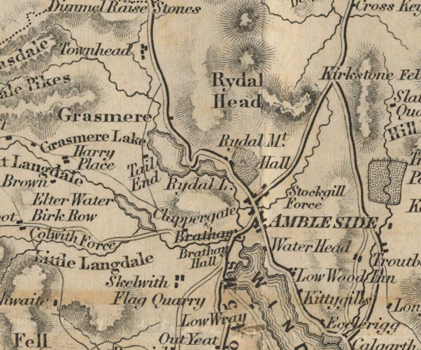 FD02NY30.jpg "Flag Quarry" At Skelwith. item:- JandMN : 100.1 Image © see bottom of page |
|
|
|
||
| Glover, David: 2014: Quarries of Lakeland: Bookcase (Carlisle, Cumbria) |
||
|
|
||
Lakes Guides menu.