 Old Cumbria Gazetteer
 |
 |
|
||
| Lamplugh Cross, Lamplugh | ||||
| Lamplugh Cross | ||||
| site name:- | road, Egremont to Cockermouth | |||
| civil parish:- | Lamplugh (formerly Cumberland) | |||
| county:- | Cumbria | |||
| locality type:- | locality | |||
| locality type:- | buildings | |||
| locality type:- | road junction | |||
| coordinates:- | NY07631992 | |||
| 1Km square:- | NY0719 | |||
| 10Km square:- | NY01 | |||
|
|
||||
| evidence:- | old map:- OS County Series (Cmd 62 14) placename:- Lamplugh Cross |
|||
| source data:- | Maps, County Series maps of Great Britain, scales 6 and 25
inches to 1 mile, published by the Ordnance Survey, Southampton,
Hampshire, from about 1863 to 1948. "Lamplugh Cross" "Guide Post" |
|||
|
|
||||
| evidence:- | old map:- Ogilby 1675 (plate 96) |
|||
| source data:- | Road strip map, hand coloured engraving, the Road from Kendal to
Cockermouth, and the Road from Egremond to Carlisle, scale about
1 inch to 1 mile, by John Ogilby, London, 1675.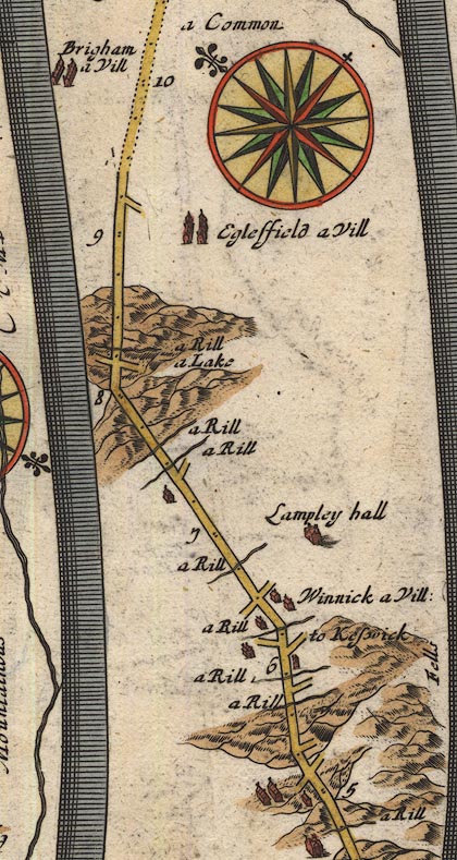 OG96Bm05.jpg In mile 6, Cumberland. Road junction. item:- JandMN : 22 Image © see bottom of page |
|||
|
|
||||
| evidence:- | old map:- Bowen and Kitchin 1760 placename:- Lampley |
|||
| source data:- | Map, hand coloured engraving, A New Map of the Counties of
Cumberland and Westmoreland Divided into their Respective Wards,
scale about 4 miles to 1 inch, by Emanuel Bowen and Thomas
Kitchin et al, published by T Bowles, Robert Sayer, and John
Bowles, London, 1760.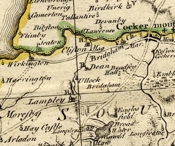 BO18NY02.jpg "Lampley / R" circle, building and tower, rectory item:- Armitt Library : 2008.14.10 Image © see bottom of page |
|||
|
|
||||
| evidence:- | old map:- Otley 1818 placename:- Cross |
|||
| source data:- | Map, uncoloured engraving, The District of the Lakes,
Cumberland, Westmorland, and Lancashire, scale about 4 miles to
1 inch, by Jonathan Otley, 1818, engraved by J and G Menzies,
Edinburgh, Scotland, published by Jonathan Otley, Keswick,
Cumberland, et al, 1833.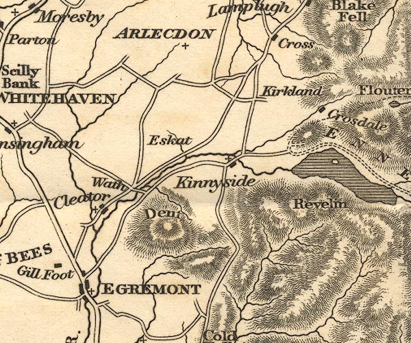 OT02NY01.jpg item:- JandMN : 48.1 Image © see bottom of page |
|||
|
|
||||
| places:- |
|
|||
 Lakes Guides menu.