 Old Cumbria Gazetteer
 |
 |
|
| Height of Patton, Whinfell | ||
| Height of Patton | ||
| Patton Hill | ||
| locality:- | Patton | |
| civil parish:- | Whinfell (formerly Westmorland) | |
| county:- | Cumbria | |
| locality type:- | hill | |
| coordinates:- | SD550967 | |
| 1Km square:- | SD5596 | |
| 10Km square:- | SD59 | |
| altitude:- | 680 feet | |
| altitude:- | 207m | |
|
|
||
| evidence:- | probably old map:- Ogilby 1675 (plate 38) placename:- Betome Hill |
|
| source data:- | Road strip map, hand coloured engraving, continuation of the
Road from London to Carlisle, scale about 1 inch to 1 mile, by
John Ogilby, London, 1675.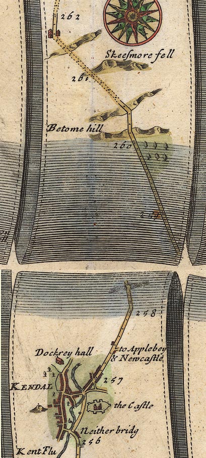 OG38m257.jpg In mile 260, Westmorland. Road ascends and descends:- "Betome hill" item:- JandMN : 21 Image © see bottom of page |
|
|
|
||
| evidence:- | probably old map:- Morden 1695 (Wmd) placename:- Betone Hill |
|
| source data:- | Map, hand coloured engraving, Westmorland, scale about 2.5 miles to 1 inch, by Robert
Morden, published by Abel Swale, the Unicorn, St Paul's Churchyard, Awnsham, and John
Churchill, the Black Swan, Paternoster Row, London, 1695. MD10SD49.jpg "Betone Hill" Hillock(s). item:- JandMN : 24 Image © see bottom of page |
|
|
|
||
| evidence:- | probably old map:- Bowen 1720 (plate 94) placename:- Belome Hill |
|
| source data:- | Strip maps, uncoloured engravings, road maps, The Road from
London to Carlisle, scale about 2 miles to 1 inch, with sections
in Lancashire and Westmorland, published by Emanuel Bowen, St
Katherines, London, 1720.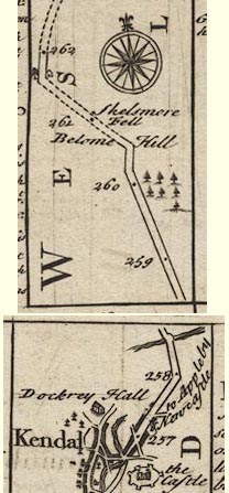 B094m257.jpg At mile 260-261. item:- Dove Cottage : 2007.38.100 Image © see bottom of page |
|
|
|
||
| evidence:- | old map:- Simpson 1746 map (Wmd) placename:- Belome Hill |
|
| source data:- | Map, uncoloured engraving, Westmorland, scale about 8 miles to 1
inch, printed by R Walker, Fleet Lane, London, 1746. SMP2SDP.jpg "Belome Hill" Labelled alongside the road. item:- Dove Cottage : 2007.38.59 Image © see bottom of page |
|
|
|
||
| evidence:- | old map:- Bowen and Kitchin 1760 placename:- Betone Hill |
|
| source data:- | Map, hand coloured engraving, A New Map of the Counties of
Cumberland and Westmoreland Divided into their Respective Wards,
scale about 4 miles to 1 inch, by Emanuel Bowen and Thomas
Kitchin et al, published by T Bowles, Robert Sayer, and John
Bowles, London, 1760.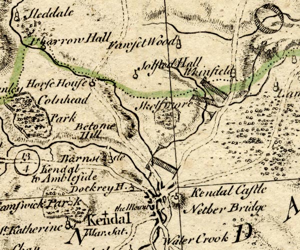 BO18SD49.jpg "Betone Hill" hill hachuring item:- Armitt Library : 2008.14.10 Image © see bottom of page |
|
|
|
||
| evidence:- | old map:- Jefferys 1770 (Wmd) placename:- Height of Patton |
|
| source data:- | Map, 4 sheets, The County of Westmoreland, scale 1 inch to 1
mile, surveyed 1768, and engraved and published by Thomas
Jefferys, London, 1770.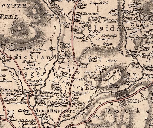 J5SD59NW.jpg "Height of Patton" hill hachuring; hill or mountain; and circle, labelled in italic lowercase text; settlement, farm, house, or hamlet? item:- National Library of Scotland : EME.s.47 Image © National Library of Scotland |
|
|
|
||
| evidence:- | old map:- Greenwood 1824 placename:- Height of Patton |
|
| source data:- | Maps, Map of the County of Westmorland, scale about 1 inch to 1
mile, and Map of the County of Cumberland, scale about 1 inch to
1 mile, etc, by C and J Greenwood, published by George Pringle
jnr, 70 Queen Street, Cheapside, London, 1823 and 1824
respectively. |
|
|
|
||
 Lakes Guides menu.