 Old Cumbria Gazetteer
 |
 |
|
| Wath Bridge, Thirlmere | ||
| Wath Bridge | ||
| site name:- | Thirlmere | |
| civil parish:- | St John's Castlerigg and Wythburn (formerly Cumberland) | |
| county:- | Cumbria | |
| locality type:- | footbridge | |
| locality type:- | bridge | |
| coordinates:- | NY310171 (guesses) | |
| 1Km square:- | NY3117 | |
| 10Km square:- | NY31 | |
|
|
||
| evidence:- | old map:- OS County Series (Cmd 70 4) placename:- Wath Bridge |
|
| source data:- | Maps, County Series maps of Great Britain, scales 6 and 25
inches to 1 mile, published by the Ordnance Survey, Southampton,
Hampshire, from about 1863 to 1948. "Wath Bridge" Drawn as a series of three bridges from shore to island to island to shore, on the 25 inch map. The track goes from Dalehead Hall to Armboth House. |
|
|
|
||
| evidence:- | old map:- Donald 1774 (Cmd) |
|
| source data:- | Map, hand coloured engraving, 3x2 sheets, The County of Cumberland, scale about 1
inch to 1 mile, by Thomas Donald, engraved and published by Joseph Hodskinson, 29
Arundel Street, Strand, London, 1774.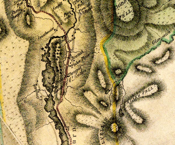 D4NY31NW.jpg track across Thirlmere item:- Carlisle Library : Map 2 Image © Carlisle Library |
|
|
|
||
| evidence:- | old map:- Clarke 1787 map (Ambleside to Keswick) |
|
| source data:- | Map, A Map of the Roads Lakes etc between Keswick and Ambleside,
scale about 2.5 ins to 1 mile, by James Clarke, engraved by S J
Neele, 352 Strand, published by James Clarke, Penrith,
Cumberland and in London etc, 1787.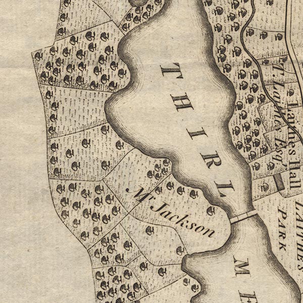 CL9NY31D.jpg Drawn in three sections. item:- private collection : 10.9 Image © see bottom of page |
|
|
|
||
| evidence:- | old print:- Smith 1795 |
|
| source data:- | Print uncoloured engraving, with some aquatint, Wyburn Lake, at the Lower End, Thirlmere,
Cumberland, drawn by John 'Warwick' Smith, engraved by F Merigot, published by R Blamire,
Strand, London, 1791.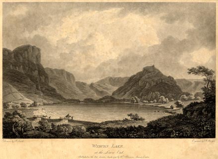 click to enlarge click to enlargePR1851.jpg printed, bottom left, right, centre "Drawn by John Smith. / Engrav'd by F. Merigot. / WYBURN LAKE, / at the Lower End. / Published as the Act directs, March, 1791, by Rd. Blamire, Strand, London." item:- Armitt Library : 2011.66 Image © see bottom of page |
|
|
|
||
| evidence:- | old text:- Capper 1808 |
|
| source data:- | Gazetteer, A Topographical Dictionary of the United Kingdom,
compiled by Benjamin Pitts Capper, published by Richard
Phillips, Bridge Street, Blackfriars, London, 1808; published
1808-29. goto source goto source"LEATH WATER or WITHBURN, a fine lake in Cumberland, ... is almost intersected in the middle by 2 peninsulas which are joined by a neat bridge of timber. ..." |
|
|
|
||
| evidence:- | old print:- Green 1815 |
|
| source data:- | Print, coloured aquatint, Leaths Water, St John's Castlerigg and Wythburn, Cumberland,
by William Green, Ambleside, Westmorland, 1815.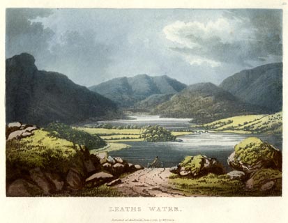 click to enlarge click to enlargeGN0531.jpg The northern part of Thirlmere; Wath Bridge then Wythburn Water behind. Plate 33 in Lake Scenery. printed at upper right:- "33" printed at bottom:- "LEATHS WATER. / Published at Ambleside, June 1, 1815, by Wm. Green." item:- Armitt Library : A6646.31 Image © see bottom of page |
|
|
|
||
| evidence:- | old print with text:- Farington 1816 |
|
| source data:- | Print, uncoloured engraving and descriptive text, Thirlmere, St John's Castlerigg
and Wythburn, Cumberland, drawn by Joseph Farington, engraved by F R Hay, published
by T Cadell and W Davies, Strand, London, 1815.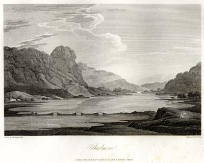 click to enlarge click to enlargeFA0413.jpg printed, bottom left, right, centre "Drawn by J. Farington R.A. / Engraved by F. R. Hay. / Thirlmere. / London Published Septr. 15, 1815, by T. Cadell &W. Davies, Strand." Descriptive text:- "... There is one peculiar feature belonging to Thirlmere, which distinguishes it from all the other Lakes of Cumberland. Near the middle, the shores of this Lake, on each side, nearly unite; and have been connected together by an Alpine bridge of three arches, which has been thrown over it for the convenience of the inhabitants. This bridge appears in the foreground of our engraving, and the view from it up the Lake is singularly romantic." item:- Armitt Library : A6666.13 Image © see bottom of page |
|
|
|
||
| evidence:- | descriptive text:- Otley 1823 (5th edn 1834) |
|
| source data:- | Guide book, A Concise Description of the English Lakes, the
mountains in their vicinity, and the roads by which they may be
visited, with remarks on the mineralogy and geology of the
district, by Jonathan Otley, published by the author, Keswick,
Cumberland now Cumbria, by J Richardson, London, and by Arthur
Foster, Kirkby Lonsdale, Cumbria, 1823; published 1823-49,
latterly as the Descriptive Guide to the English Lakes. goto source Page 16:- "... [Thirlmere] is divided into an upper and lower lake, between which a picturesque wooden bridge leads to Armboth House. ..." |
|
|
|
||
| evidence:- | descriptive text:- Ford 1839 (3rd edn 1843) |
|
| source data:- | Guide book, A Description of Scenery in the Lake District, by
Rev William Ford, published by Charles Thurnam, Carlisle, by W
Edwards, 12 Ave Maria Lane, Charles Tilt, Fleet Street, William
Smith, 113 Fleet Street, London, by Currie and Bowman,
Newcastle, by Bancks and Co, Manchester, by Oliver and Boyd,
Edinburgh, and by Sinclair, Dumfries, 1839. goto source Page 47:- "..." "[Leathes Water] ... is nearly equally divided by two promontories, connected by a series of wooden bridges and stone causeways at a place where it is fordable." |
|
|
|
||
| evidence:- | old text:- Martineau 1855 |
|
| source data:- | Guide book, A Complete Guide to the English Lakes, by Harriet
Martineau, published by John Garnett, Windermere, Westmorland,
and by Whittaker and Co, London, 1855; published 1855-76. goto source Page 69:- "... The track leads by the margin of the lake, and through a shady lane, and a farm yard, to the bridge by which the lake is to be crossed. The water is shallow there, between two promontories; so that piers are easily built, with little wooden bridges at intervals: and thus is solved what is to novices a great mystery;- how there can be a bridge over a lake. ..." |
|
|
|
||
| evidence:- | old photograph:- Bell 1880s-1940s |
|
| source data:- | Photograph, sepia, Wath Bridge, Thirlmere, St John's Castlerigg and Wythburn, Cumberland,
by Herbert Bell, photographer, Ambleside, Westmorland, 1890s.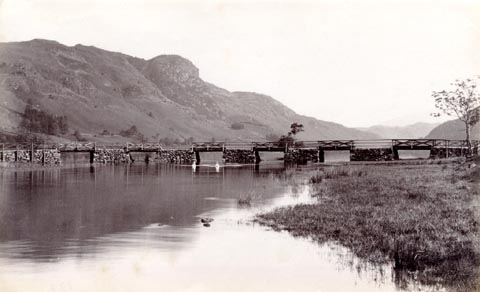 click to enlarge click to enlargeHB0728.jpg item:- Armitt Library : ALPS392 Image © see bottom of page |
|
|
|
||
| evidence:- | old photograph:- Bell 1880s-1940s |
|
| source data:- | Photograph, sepia, Wath Bridge and Helvellyn, Thirlmere, St John's Castlerigg and
Wythburn, Cumberland, by Herbert Bell, photographer, Ambleside, Westmorland, 1890s.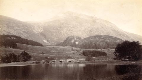 click to enlarge click to enlargeHB0729.jpg item:- Armitt Library : ALPS393 Image © see bottom of page |
|
|
|
||
| evidence:- | old photograph:- Bell 1880s-1940s |
|
| source data:- | Photograph, sepia, Wath Bridge, Thirlmere, St John's Castlerigg and Wythburn, Cumberland,
by Herbert Bell, Ambleside, Westmorland, 1890s?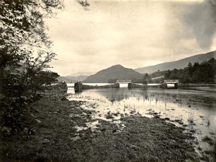 click to enlarge click to enlargeHB0291.jpg item:- Armitt Library : ALPS648 Image © see bottom of page |
|
|
|
||
| evidence:- | old photograph:- Bell 1880s-1940s |
|
| source data:- | Photograph, sepia, Wath Bridge, Thirlmere, St John's Castlerigg and Wythburn, Cumberland,
by Herbert Bell, Ambleside, Westmorland, 1890s?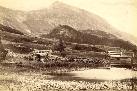 click to enlarge click to enlargeHB0357.jpg item:- Armitt Library : ALPS734 Image © see bottom of page |
|
|
|
||
| evidence:- | old text:- Philip/Wilson 1890s |
|
| source data:- | Guide book, The English Lake District, published by George
Philip and Son, 32 Fleet Street, London, Philip, Son and Nephew,
Liverpool, Lancashire, and Titus Wilson, Kendal, Westmorland,
now Cumbria, before 1895. "... It [Thirlmere] was about ¼of a mile broad, but so narrowed at one point that it was crossed by three successive foot-bridges,- a conspicuous feature in all old views of the Lake. ..." |
|
|
|
||
| evidence:- | old print:- Heywood 1906 placename:- Submerged Bridges, The |
|
| source data:- | Print, engraving, The Submerged Bridges, Wath Bridge, Thirlmere, St John's Castlerigg
and Wythburn, Cumberland, engraved by ?Lancton, published by Abel Heywood and Son,
56-58 Oldham Street, Manchester, and by Simpkin, Marshall, Hamilton, Kent and Co,
Ave Maria Lane, Paternoster Row, London, 1906.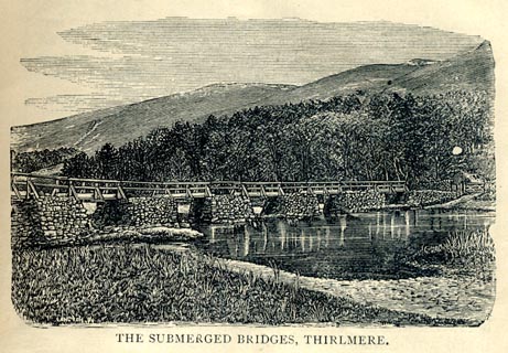 click to enlarge click to enlargeHW1E11.jpg In a Guide to Keswick and its Vicinity in the Penny Guide Books series. "'The above is a view that will never be seen again by mortal eye. ... now submerged by the raising of the water in store for Manchester." printed at bottom:- "THE SUBMERGED BRIDGES, THIRLMERE." printed at lower left:- "[LANCTON Sc]" item:- JandMN : 348.11 Image © see bottom of page |
|
|
|
||
| evidence:- | old print:- Harwood 1895 placename:- Celtic Bridge, The |
|
| source data:- | Print, halftone photograph, View of Thirlmere, showing Ford and Celtic Bridge across
Lake, Cumberland, by Meisenbach, published by Henry Blacklock and Co, Albert Square,
Manchester, 1895.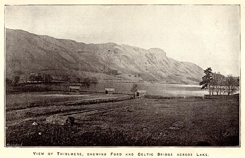 click to enlarge click to enlargeHRW303.jpg Tipped in opposite p.38 of the History and Description of the Thirlmere Water Scheme, by Sir John James Harwood. printed at bottom:- "VIEW OF THIRLMERE, SHOWING FORD AND CELTIC BRIDGE" printed at lower left:- "Meisenbach" item:- Armitt Library : A660.5 Image © see bottom of page |
|
|
|
||
| evidence:- | old drawing:- |
|
| source data:- | Drawing, Thirlmere, Cumberland, by John Harper, 1840.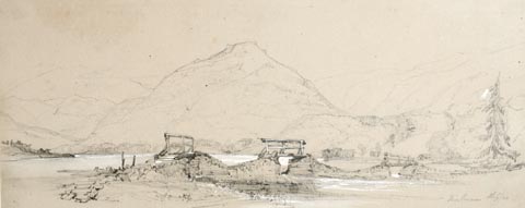 click to enlarge click to enlargePR1383.jpg View of Thirlmere with stone wall intersected by three small wooden bridges in the foreground. Hills and trees in the background. Executed in pencil with touches of white gouache on buff coloured paper. Preparatory sketch drawn on the spot by the artist. at bottom right:- "Thirlmere. 8 Sep./40" item:- Tullie House Museum : 2009.89.26 Image © Tullie House Museum |
|
|
|
||
| evidence:- | old print:- Rose 1832-35 placename:- Thirlmere Bridge |
|
| source data:- | Print, engraving, Thirlmere Bridge, Looking North, Cumberland, by Thomas Allom, engraved
by W le Petit, 1833.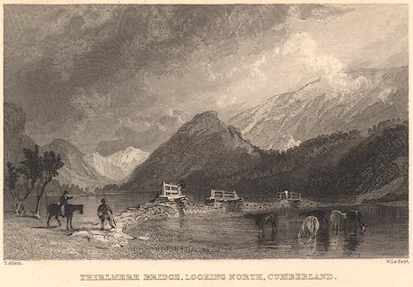 click to enlarge click to enlargeR241.jpg "Thirlmere Bridge, Looking North, Cumberland" item:- JandMN : 96.14 Image © see bottom of page |
|
|
|
||
Lakes Guides menu.