 Old Cumbria Gazetteer
 |
 |
|
| Thornton Force, North Yorkshire | ||
| Thornton Force | ||
| site name:- | Kingsdale Beck | |
| county:- | North Yorkshire | |
| locality type:- | waterfall | |
| coordinates:- | SD694753 | |
| 1Km square:- | SD6975 | |
| 10Km square:- | SD67 | |
|
|
||
| evidence:- | descriptive text:- West 1778 (11th edn 1821) placename:- Thornton Force |
|
| source data:- | Guide book, A Guide to the Lakes, by Thomas West, published by
William Pennington, Kendal, Cumbria once Westmorland, and in
London, 1778 to 1821. goto source goto sourceTour to the Caves in the West Riding of Yorkshire, late 18th century Page 245:- "... When we had gone about a mile [from Thornton Church-stile], we were entertained with a fine cascade, called Thornton-force, near some slate quarries, made by the river issuing out of Kingsdale. This cataract had some features different to any we had yet seen among the lakes; but which greatly conduced to render it peculiarly engaging. Part of the river tumbled with impetuosity from the top of the stratum of huge rocks, perpendicularly, about 20 yards: another part of it, in search of a nearer and less violent course, had discovered a subterranean passage, and gushed out of the side of the precipice; when they immediately again united their streams in a large, rounded, deep, and black bason at the bottom. From the margin of this pool the view may be taken to greatest advantage: the high rock on the south and opposite side about a half a dozen yards higher than the cascade, and mantled with shrubs and ivy, leaves nothing on that hand for the imagination to supply. If the archetype was not in being, it might be thought the subterranean stream was added to the picture, by the ingenuity of the artist, in order to give a finishing stroke to the beauty of the scene. This little river is worthy the company of the curious tourist for about a mile along its course through a deep grotesque glen, fortified on each side by steep or impending high rocks. ..." goto sourcePage 252:- "... This bed of slate runs nearly from south to north, by this place [quarry 1 mile north of Ingleton] and the quarry near Thornton-force. Its length may be traced two or three miles, though about 200 or 300 yards in breadth - and indeed, of good slate, but a few yards broad. ... ... We crossed over to take a second view of Thornton-force, on the south side of the Kingsdale river, and followed its murmuring stream down a deep glen, fortified with high precipices on each side, to Ingleton; ..." |
|
|
|
||
| evidence:- | descriptive text:- Otley 1823 (8th edn 1849) placename:- Thornton Force |
|
| source data:- | Guide book, A Concise Description of the English Lakes, the
mountains in their vicinity, and the roads by which they may be
visited, with remarks on the mineralogy and geology of the
district, by Jonathan Otley, published by the author, Keswick,
Cumberland now Cumbria, by J Richardson, London, and by Arthur
Foster, Kirkby Lonsdale, Cumbria, 1823; published 1823-49,
latterly as the Descriptive Guide to the English Lakes. goto source Page 196:- "..." "Situate in a romantic glen, about a mile from Thornton Church Stile, is THORNTON FORCE, a remarkably fine waterfall. The river here falls, with a noise like thunder, at one leap, about 30 yards, through an opening between two rocks. We stand at the top, surveying the scene, which is extremely wild and picturesque. The rocks are fringed with trees, which impart a certain air of gloom and veneration around the spot; and the spray arising from the deep basin beneath, resembles mist, or wreaths of smoke from a furness, and sprinkles the ground for many yards around the fall. From below a picture is exhibited which leaves little for the imagination to supply. The white sheet of flowing water - the black receptacle beneath - the tree-clad rocks - and the wild mountain scenery around, form a landscape as complete as the most fastidious artiste could desire." |
|
|
|
||
| evidence:- | old map:- Balderston c1890 map placename:- Thornton Foss |
|
| source data:- | Map, the hills in the Ingleton area, probably by Robert R
Balderston, engraved by Goodall and Suddick, Leeds, West
Yorkshire, about 1890.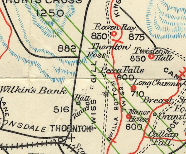 BS1SD67X.jpg "Thornton Foss" item:- private collection : 27.1 Image © see bottom of page |
|
|
|
||
Lakes Guides menu.