 Old Cumbria Gazetteer
 |
 |
|
| included in:- |
 Crummock Water Crummock Water |
|
| viewpoint, Dob Ley Head | ||
| site name:- | Dob Ley Head | |
| site name:- | Brackenthwaite Hows | |
| civil parish:- | Buttermere (formerly Cumberland) | |
| county:- | Cumbria | |
| locality type:- | viewpoint | |
| coordinates:- | NY15232142 (about) | |
| 1Km square:- | NY1521 | |
| 10Km square:- | NY12 | |
|
|
||
| evidence:- | probably descriptive text:- West 1778 (11th edn 1821) |
|
| source data:- | Guide book, A Guide to the Lakes, by Thomas West, published by
William Pennington, Kendal, Cumbria once Westmorland, and in
London, 1778 to 1821. goto source Page 142:- "From the bridge at the foot of the lake, ascend the road to Brackenthwaite. At the ale-house, Scalehill, take a guide to the top of the rock, above Mr. Bertie's woods, and have an entirely new view of Cromack-water. The river Cocker is seen winding through a beautiful and rich cultivated vale, spreading far to the north, variegated with woods, groves, and hanging grounds, in every pleasing variety. The most singular object in this vale of Lorton and Brackenthwaite, is a high-crowned topt (sic) rock that divides the vale, and raises a broken craggy head over hanging woods, that skirt the sloping sides, which are cut into waving inclosures and varied with groves and patches of coppice wood. To the west a part of Lowes-water is seen, under a fringe of trees at High-cross. Behind you, awful Grasmire (the Skiddaw of the vale) frowns in all the majesty of furrowed rock, cut almost perpendicularly to the centre by the water-falls of ages. The swell of a cataract is here heard, but entirely concealed within the gloomy recess of a rocky dell, formed by the rival mountains, Grasmire and Whiteside. At their feet, lie the mighty ruins, brought down from the mountains, by the memorable water-spout, that deluged all the vale, in September, 1760." goto sourcePage 143:- "After this, the mountains become humble hills, and terminate the sweet vale, that stretches from the feet of Black-crag and Carling-knot, and spreads itself into a country watered by the Cocker." |
|
|
|
||
| evidence:- | old map:- Crosthwaite 1783-94 (But/Cru/Low) |
|
| source data:- | Map, uncoloured engraving, An Accurate Map of Buttermere,
Crummock and Loweswater Lakes, scale about 3 inches to 1 mile,
by Peter Crosthwaite, Keswick, Cumberland, 1794, version
published 1800.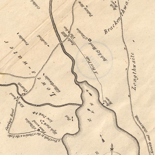 CT8NY12K.jpg "Dob Ley Head / 3d. Station" item:- Armitt Library : 1959.191.2 Image © see bottom of page |
|
|
|
||
| evidence:- | old map:- Crosthwaite 1783-94 (But/Cru/Low) placename:- station, Buttermere, Crosthwaite 3 |
|
| source data:- | Series of maps, An Accurate Map of the Matchless Lake of
Derwent, of the Grand Lake of Windermere, of the Beautiful Lake
of Ullswater, of Broadwater or Bassenthwaite Lake, of Coniston
Lake, of Buttermere, Crummock and Loweswater Lakes, and
Pocklington's Island, by Peter Crosthwaite, Kendal, Cumberland
now Cumbria, 1783 to 1794. "Dob Ley Head / 3d. Station" |
|
|
|
||
| evidence:- | old text:- Martineau 1855 |
|
| source data:- | Guide book, A Complete Guide to the English Lakes, by Harriet
Martineau, published by John Garnett, Windermere, Westmorland,
and by Whittaker and Co, London, 1855; published 1855-76. goto source Page 86:- "A few minutes will take the stranger up to the Station, by a path from the [Scale Hill] inn door. The Station is a hill in Lanthwaite Wood, whence a magnificent view is obtained of the stern mountain group, (the central group of the whole district,) on the one hand, and the rich levels of Lorton Vale on the other, backed, in favourable lights, by the Scotch mountains. This spot is one on which to linger through a long summer day, pacing the sward, and choosing seats from rock to rock, along the whole crest. ..." |
|
|
|
||
| person:- | map maker : Crosthwaite, Peter |
|
| place:- | Buttermere / Crummock Water / Loweswater | |
| date:- | 1794 |
|
| period:- | 18th century, late | |
| period:- | 1790s | |
| item:- | map; Accurate Map of Buttermere, Crummock and Loweswater Lakes |
|
|
|
||
Lakes Guides menu.