 Old Cumbria Gazetteer
 |
 |
|
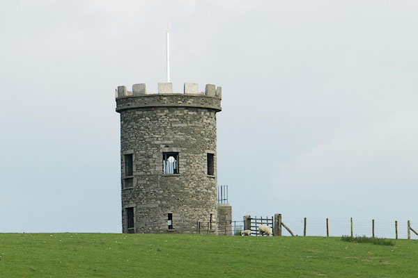
| St Anthony's Tower, Milnthorpe | ||
| St Anthony's Tower | ||
| site name:- | St Anthony's Hill | |
| locality:- | Milnthorpe | |
| civil parish:- | Milnthorpe (formerly Westmorland) | |
| county:- | Cumbria | |
| locality type:- | folly | |
| locality type:- | tower | |
| locality type:- | summer house (once) | |
| coordinates:- | SD49878218 | |
| 1Km square:- | SD4982 | |
| 10Km square:- | SD48 | |
|
|
||
 BQS29.jpg (taken 5.6.2009) |
||
|
|
||
| evidence:- | old map:- OS County Series (Wmd 42 15) placename:- St Anthony's Tower |
|
| source data:- | Maps, County Series maps of Great Britain, scales 6 and 25
inches to 1 mile, published by the Ordnance Survey, Southampton,
Hampshire, from about 1863 to 1948. |
|
|
|
||
| evidence:- | database:- Listed Buildings 2010 placename:- St Anthony's Tower |
|
| source data:- | courtesy of English Heritage "ST ANTHONY'S TOWER APPROXIMATELY 150 METRES EAST OF A6 NORTH OF MILNTHORPE / / A6 / MILNTHORPE / SOUTH LAKELAND / CUMBRIA / II / 75553 / SD4987682186" |
|
| source data:- | courtesy of English Heritage "Folly in shape of Tower. Probably early C19 (recorded as in existence by 1832). Stone rubble with dressed stone corniced parapet. Circular plan. 2 storeys. 5 window openings, not glazed with roughly cut lintels and cills and and doors approached by flight of external steps at first floor. Ground floor has window opening to south and slit openings to remaining sides. Visible as landscape feature from some considerable distance all round, notably from Dallam Towers whose owner in 1832 prevented any further extension of the development along Church Street in Milnthorpe so that his view of the folly from his house was not obscured. Further information: CURWEN, J F History of Heversham with Milnthorpe, pub. Titus Wilson 1930, p11." |
|
|
|
||
| hearsay:- |
Possibly built by George Webster, as a summer house in the park attached to Dalam
Tower. It was moved here in the late 19th century. |
|
|
|
||
 Lakes Guides menu.