 Old Cumbria Gazetteer
 |
 |
|
| Skelwith Fold, Skelwith Bridge | ||
| Skelwith Fold | ||
| locality:- | Skelwith Bridge | |
| civil parish:- | Skelwith (formerly Lancashire) | |
| county:- | Cumbria | |
| locality type:- | buildings | |
| coordinates:- | NY35060284 (etc) | |
| 1Km square:- | NY3502 | |
| 10Km square:- | NY30 | |
|
|
||
| evidence:- | old map:- OS County Series (Lan 2 6) placename:- Skelwith Fold |
|
| source data:- | Maps, County Series maps of Great Britain, scales 6 and 25
inches to 1 mile, published by the Ordnance Survey, Southampton,
Hampshire, from about 1863 to 1948. |
|
|
|
||
| evidence:- | old print:- Green 1822 (plate 9) placename:- Skelwith Fold item:- forestair |
|
| source data:- | Print, uncoloured soft ground etching, Skelwith Fold, Skelwith, Lancashire, by William
Green, Ambleside, Westmorland, 1822.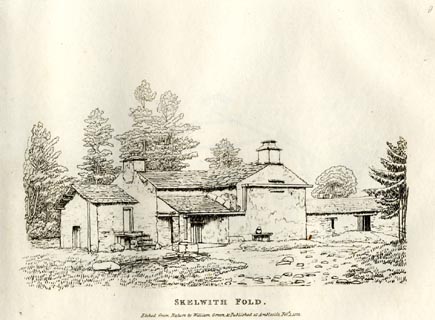 click to enlarge click to enlargeGN0809.jpg Plate 9 in Forty Etchings from Nature. printed at bottom:- "SKELWITH FOLD. / Etched from Nature by William Green, &Published at Ambleside, Feby. 1, 1822." item:- Armitt Library : A6644.9 Image © see bottom of page |
|
|
|
||
| evidence:- | old text:- Martineau 1855 |
|
| source data:- | Guide book, A Complete Guide to the English Lakes, by Harriet
Martineau, published by John Garnett, Windermere, Westmorland,
and by Whittaker and Co, London, 1855; published 1855-76. goto source goto sourcePage 47:- "... Skelwith Fold. There the stranger must alight again, and go through a field gate to the right, to a rocky point, where he commands the finest view of the valley and its environs. ..." |
|
|
|
||
Lakes Guides menu.