 Old Cumbria Gazetteer
 |
 |
|
| Scales Tarn, Threlkeld | ||
| runs into:- |  Scales Beck Scales Beck |
|
|
|
||
| Scales Tarn | ||
| locality:- | Saddleback | |
| civil parish:- | Threlkeld (formerly Cumberland) | |
| county:- | Cumbria | |
| locality type:- | tarn | |
| coordinates:- | NY32882813 | |
| 1Km square:- | NY3228 | |
| 10Km square:- | NY32 | |
| altitude:- | 1953 feet | |
| altitude:- | 595m | |
|
|
||
 BPC95.jpg (taken 2.5.2008) 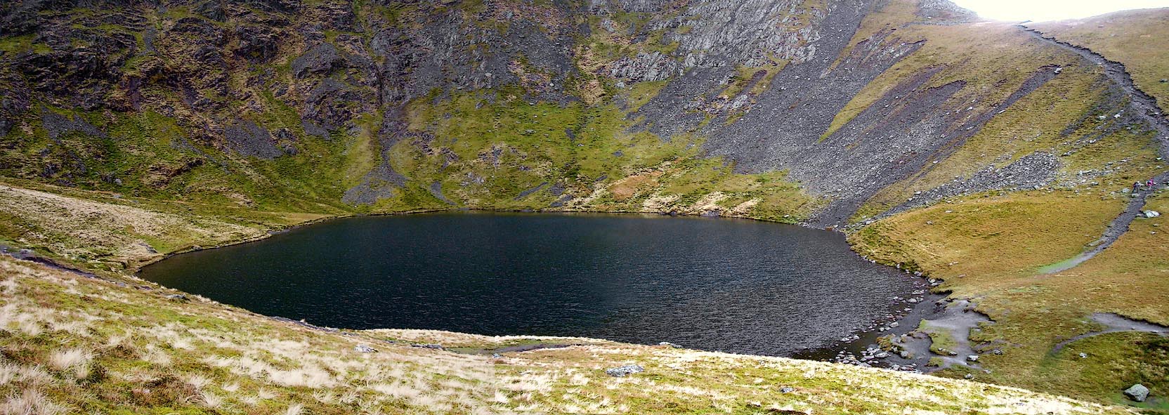 Click to enlarge BPC94.jpg (taken 2.5.2008) |
||
|
|
||
| evidence:- | old map:- OS County Series (Cmd 57 9) placename:- Scales Tarn |
|
| source data:- | Maps, County Series maps of Great Britain, scales 6 and 25
inches to 1 mile, published by the Ordnance Survey, Southampton,
Hampshire, from about 1863 to 1948. |
|
|
|
||
| evidence:- | perhaps old map:- Gents Mag 1747 |
|
| source data:- | Map, uncoloured engraving, perspective view, Caudbeck Fells ie
Caldbeck Fells, scale about 1+ miles to 1 inch, published in the
Gentleman's Magazine, 1747.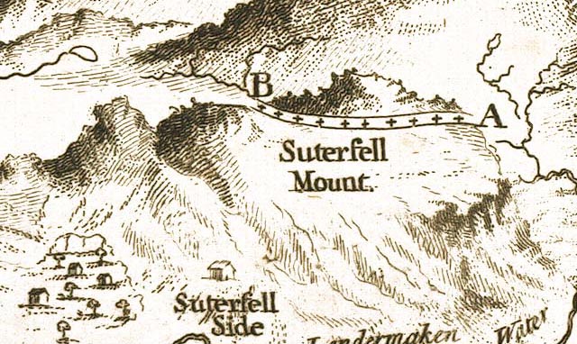 GM1402.jpg outline; tarn item:- Carlisle Library : Map 43 Image © Carlisle Library |
|
|
|
||
| evidence:- | old map:- Donald 1774 (Cmd) |
|
| source data:- | Map, hand coloured engraving, 3x2 sheets, The County of Cumberland, scale about 1
inch to 1 mile, by Thomas Donald, engraved and published by Joseph Hodskinson, 29
Arundel Street, Strand, London, 1774.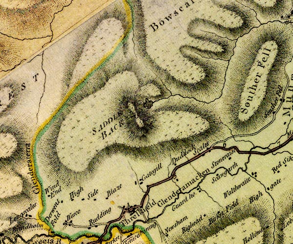 D4NY32NW.jpg lake, on Blencathra item:- Carlisle Library : Map 2 Image © Carlisle Library |
|
|
|
||
| evidence:- | old text:- Clarke 1787 placename:- Threlkeld Tarn item:- echoes; volcano |
|
| source data:- | Guide book, A Survey of the Lakes of Cumberland, Westmorland,
and Lancashire, written and published by James Clarke, Penrith,
Cumberland, and in London etc, 1787; published 1787-93. goto source Page 58:- "... account given me by Mr Crosfeild, who very diligently searched into the nature of this [Saddleback] and other of our Cumbrian mountains." ""Having been often struck with the singular situation and appearance of that piece of water which is commonly known by the name of Threlkeld Tarn, I formed many conjectures respecting its formation. I was for some time of opinion that it had been formed by water spouts frequently breaking on top of the mountain; but when I reflected that water could hardly be powerful enough to excavate solid rocks in so wonderful a manner, I was obliged to give up this opinion, and began to imagine that no agent of nature, except fire, could produce such an astonishing effect. In order to satisfy myself on that head, I determined to inspect narrowly into the minerals of the adjacent country. My first researches were naturally directed to the brooks in the neighbourhood: there I was pleasingly astonished to find vitrified lumps, resembling glass-house slags, in some places lying loose, in others evidently fitted by fusion to the crevices and irregularities of the stones among which they lay. I likewise found many large blocks of stone intermixed with marcasite in such plenty as to be inflammable; in other places there was a stratum of matter, a foot or more in thickness, which lay upon the rocks, and which seemed to have undergone a great degree of heat; above this was a stratum of sand intermixed with clay, pebbles, &c.; above that another stratum like the first; and, finally, a stratum of the common compost of the country soil, covered with peat earth. These appearances induced me to undertake a journey to the mountain; ..." "..." goto sourcePage 59:- ""[pro]ceeded along the top of this hill, ascending gently about half a mile, when I arrived at the top of Scales-Fell, which may be called the second landing-place. Here I came to the brink of the first of those hideous chasms which furrow the southern face of this mountain. Nearly on a level with this is the Tairn, of which more hereafter. ... I then descended towards the Tairn, which is an oval piece of water, about two hundred yards from East to West, and about an hundred and fifty from North to South; it is surrounded by rocks, except an opening towards the East, where they have evidently broken down. Standing near this opening I discharged my gun, when the echo was inconceivable: it resembled a peal of thunder bursting over my head, and was so prodigiously loud and fierce, that my dog (though a staunch pointer) crept trembling behind me." ""Hence I proceeded along the rivulet which issues from the Tairn, seeking for minerals, and found some, which I sent to Edinburgh, to that incomparable chemist Dr Black, Professor of Chemistry in that University. I likewise found several immense stones, whose original places I could sometimes trace; and one in particular, which must have weighed near a hundred tons, and which must have been forced at least three hundred yards from its original situation: another I remarked of prodigious size separated about a foot and an half from its parent rock, and which cannot have fallen, as it lies now rather higher than the place it came from, as may be plainly traced by the veins and inequalities of each:- Evident marks of some dreadful convulsion! I then returned, partly along the rivulet, and partly the road I came. Upon the whole, I cannot help concluding, that this mountain has been formerly in a volcanic state, and that this Tairn has been the mouth or crater of the mountain. A collateral proof, indeed, I draw from the stones in the neighbourhood, which have almost every one of them the appearance of having been burnt."" |
|
|
|
||
| evidence:- | old map:- Cooper 1808 |
|
| source data:- | Map, uncoloured engraving, Cumberland, scale about 10.5 miles to
1 inch, drawn and engraved by Cooper, published by R Phillips,
Bridge Street, Blackfriars, London, 1808. click to enlarge click to enlargeCOP3.jpg outline, shaded; lake item:- JandMN : 86 Image © see bottom of page |
|
|
|
||
| evidence:- | old map:- Otley 1818 |
|
| source data:- | Map, uncoloured engraving, The District of the Lakes,
Cumberland, Westmorland, and Lancashire, scale about 4 miles to
1 inch, by Jonathan Otley, 1818, engraved by J and G Menzies,
Edinburgh, Scotland, published by Jonathan Otley, Keswick,
Cumberland, et al, 1833.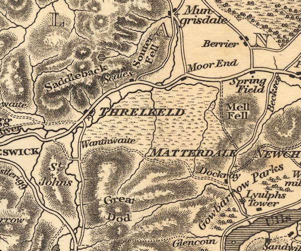 OT02NY32.jpg item:- JandMN : 48.1 Image © see bottom of page |
|
|
|
||
| evidence:- | old print:- Fielding and Walton 1821 (plate 3) placename:- Purple Tarn |
|
| source data:- | Print, coloured aquatint, Purple Tarn, Top of Saddleback, ie Scales Tarn, Threlkeld,
Cumberland, drawn by Theodore H A Fielding, published by R Ackermann, 101 Strand,
London, 1821.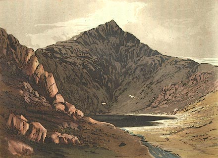 click to enlarge click to enlargeFW0103.jpg Atkinson Pike in the background. Tipped in opposite p.4 in A Picturesque Tour of the English Lakes. item:- Dove Cottage : 1993.R566.3 Image © see bottom of page |
|
|
|
||
| evidence:- | descriptive text:- Otley 1823 (5th edn 1834) item:- depth, Scales Tarn; volcano; caldera |
|
| source data:- | Guide book, A Concise Description of the English Lakes, the
mountains in their vicinity, and the roads by which they may be
visited, with remarks on the mineralogy and geology of the
district, by Jonathan Otley, published by the author, Keswick,
Cumberland now Cumbria, by J Richardson, London, and by Arthur
Foster, Kirkby Lonsdale, Cumbria, 1823; published 1823-49,
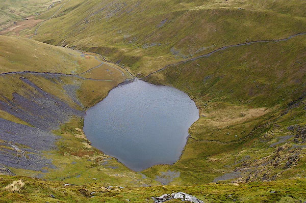
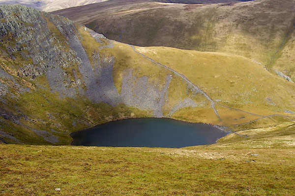
latterly as the Descriptive Guide to the English Lakes. goto source Page 38:- "Scales Tarn, on the east end of the mountain Saddleback, is an oval piece of water covering an area of three acres and a half, its two diameters being 176 and 124 yards, its depth 18 feet; and uninhabited by the finny tribe. Some very exaggerated descriptions of this tarn have found their way into the history of Cumberland and other publications. From its gloomy appearance, occasioned by being overshadowed by steep rocks, its depth was supposed to be very great, and it has been represented as the crater of an extinct volcano; an assumption not supported by present appearances. Its stream, nearly encompassing Souterfell, is called the Glenderamakin, which, passing Threlkeld, joins that from Thirlmere to form the Greta." goto sourcePage 69:- "... in a deep hollow, below a rocky precipice on its [Saddleback's] eastern end, a small, dark tarn is curiously placed." |
|
|
|
||
| evidence:- | descriptive text:- Ford 1839 (3rd edn 1843) placename:- Scales Tarn |
|
| source data:- | Guide book, A Description of Scenery in the Lake District, by
Rev William Ford, published by Charles Thurnam, Carlisle, by W
Edwards, 12 Ave Maria Lane, Charles Tilt, Fleet Street, William
Smith, 113 Fleet Street, London, by Currie and Bowman,
Newcastle, by Bancks and Co, Manchester, by Oliver and Boyd,
Edinburgh, and by Sinclair, Dumfries, 1839. goto source Page 65:- "..." "[Blancathra] ... At the base of an enormous perpendicular crag, called Tarn Crag, depending from the top, is Scales Tarn, a beautiful circular piece of transparent water, with a well defined shore, covering an area of three acres and a half, and being eighteen feet deep. Here you are engulphed in a basin of steeps, having Tarn Crag on the north, the rocks falling from Sharp Edge on the east, and on the west the soft turf on which the descent has been made. ..." |
|
|
|
||
| evidence:- | old map:- Garnett 1850s-60s H placename:- Scales Tarn |
|
| source data:- | Map of the English Lakes, in Cumberland, Westmorland and
Lancashire, scale about 3.5 miles to 1 inch, published by John
Garnett, Windermere, Westmorland, 1850s-60s. GAR2NY32.jpg "Scales Tarn" outline with shore form lines, lake or tarn item:- JandMN : 82.1 Image © see bottom of page |
|
|
|
||
| evidence:- | old text:- Martineau 1855 item:- stars at noon |
|
| source data:- | Guide book, A Complete Guide to the English Lakes, by Harriet
Martineau, published by John Garnett, Windermere, Westmorland,
and by Whittaker and Co, London, 1855; published 1855-76. goto source Page 99:- "..." "Here, too, lies another wonder,- that tarn (Scales Tarn) which is said to reflect the stars at noonday,- a marvel which we by no means undertake to avouch. The tarn is so situated at the foot of a vast precipice, and so buried among crags, that the sun never reaches it, except through a crevice in early morning. This dark water is one of the attractions which bring strangers to this mountain; ..." "..." goto sourcePage 100:- "... he [a visitor] was coaxed onwards to the tarn, where, however, he could see no stars, though it was noonday. ... ... Mr. Green, with his companion Mr. Otley, was among the earlier adventurers who stood on the highest ridge [of Saddleback]. He was so accurate an observer that his descriptions of unfrequented and unalterable places will never be antiquated. "From Linthwaite Pike," he says, "on soft green turf, we descended steeply, first southward, and then in an easterly direction to the Tarn; a beautiful circular piece of transparent water, with a well-defined shore. Here we found ourselves engulphed in a basin of steeps, having Tarn Crag on the north, the rocks falling from Sharp Edge on the east, and on the west, the soft turf on which we had made our downward progress. These side-grounds, in pleasant grassy banks, verge to the stream issuing from the lake, whence there is a charming opening to the town of Penrith; and Cross Fell seen in extreme distance. ... "" |
|
|
|
||
| evidence:- | old map:- Postlethwaite 1877 (3rd edn 1913) placename:- Scales Tarn |
|
| source data:- | Map, uncoloured engraving, Map of the Lake District Mining Field, Westmorland, Cumberland,
Lancashire, scale about 5 miles to 1 inch, by John Postlethwaite, published by W H
Moss and Sons, 13 Lowther Street, Whitehaven, Cumberland, 1877 edn 1913. PST2NY32.jpg "Scales Tarn" lake item:- JandMN : 162.2 Image © see bottom of page |
|
|
|
||
 BPC96.jpg (taken 2.5.2008) |
||
|
|
||
| notes:- |
Sir Walter Scott, in the Bridal of Triermain:- |
|
| "Never sunbeam could discern The surface of that sable tarn, In whose black mirror you may spy The stars while noonday lights the sky." |
||
| Baron 1925 |
||
|
|
||
Lakes Guides menu.