Old Cumbria Gazetteer
 |
 |
|
||
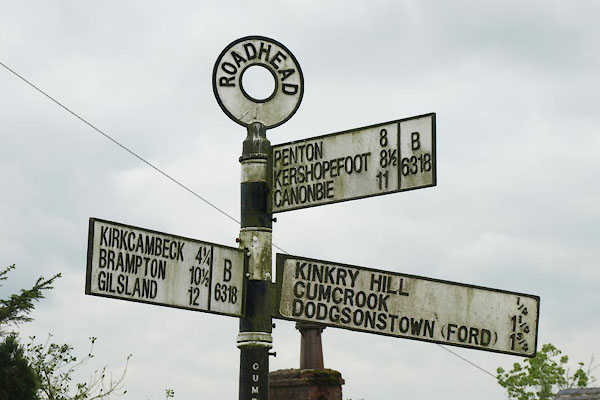
| Roadhead, Bewcastle | ||||
| Roadhead | ||||
| civil parish:- | Bewcastle (formerly Cumberland) | |||
| county:- | Cumbria | |||
| locality type:- | locality | |||
| locality type:- | buildings | |||
| coordinates:- | NY51827505 (etc) | |||
| 1Km square:- | NY5175 | |||
| 10Km square:- | NY57 | |||
|
|
||||
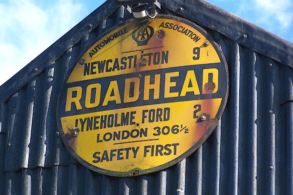 BMQ71.jpg AA village sign:- "AUTOMOBILE ASSOCIATION [AA badge] / NEWCASTLETON 9 / ROADHEAD / LYNEHOLM FORD 2 / LONDON 306½/ SAFETY FIRST" On a shed by North Bank House. (taken 15.9.2006) |
||||
|
|
||||
| evidence:- | possibly old map:- Ford 1839 map placename:- Hillhead |
|||
| source data:- | Map, uncoloured engraving, Map of the Lake District of
Cumberland, Westmoreland and Lancashire, scale about 3.5 miles
to 1 inch, published by Charles Thurnam, Carlisle, and by R
Groombridge, 5 Paternoster Row, London, 3rd edn 1843. FD02NY57.jpg "Hillhead" Building on a hill. item:- JandMN : 100.1 Image © see bottom of page |
|||
|
|
||||
| evidence:- | old map:- Post Office 1850s-1900s placename:- Roadhead |
|||
| source data:- | Post road maps, General Post Office Circulation Map for England
and Wales, for the General Post Office, London, 1850s-1900s. click to enlarge click to enlargePOF7Cm.jpg "Roadhead" map date 1909 |
|||
|
|
||||
| :- |
images courtesy of the British Postal Museum and Hampshire CC Museums |
|||
|
|
||||
| places:- |
|
|||
|
||||
|
||||
|
||||
|
||||
|
||||
|
||||
|
||||
|
||||
 Lakes Guides menu.