 Old Cumbria Gazetteer
 |
 |
|
|
| included in:- |
 road, Lancaster to Ulverston road, Lancaster to Ulverston |
||
| sands road, Lancaster Sands | |||
| Lancaster Sands road | |||
| county:- | Lancashire | ||
| site name:- | Kent Estuary | ||
| locality:- | Lancaster Sands | ||
| civil parish:- | Grange-over-Sands (formerly Lancashire) | ||
| county:- | Cumbria | ||
| locality type:- | sands road | ||
| locality type:- | route | ||
| 10Km square:- | SD47 | ||
|
|
|||
| evidence:- | old map:- Mercator 1595 (edn?) placename:- Cartlone Pass placename:- Hest Bank Pass |
||
| source data:- | Map, hand coloured engraving, Westmorlandia, Lancastria, Cestria
etc, ie Westmorland, Lancashire, Cheshire etc, scale about 10.5
miles to 1 inch, by Gerard Mercator, Duisberg, Germany, 1595,
edition 1613-16.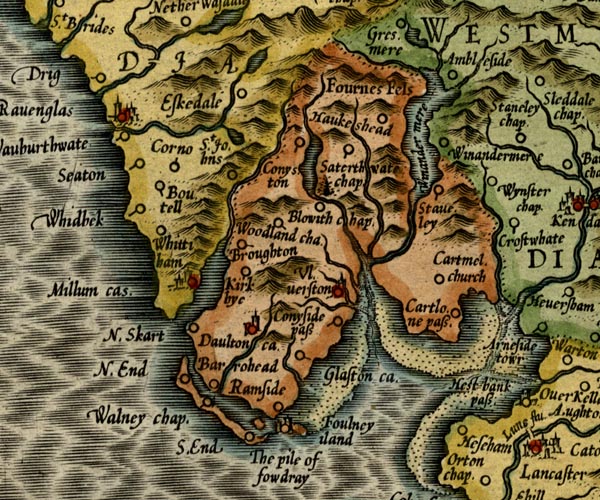 MER5LanA.jpg "Cartlone pass." circle "Hest Bank pass" circle item:- Armitt Library : 2008.14.3 Image © see bottom of page |
||
|
|
|||
| evidence:- | descriptive text:- West 1778 (11th edn 1821) item:- synodals; peter pence |
||
| source data:- | Guide book, A Guide to the Lakes, by Thomas West, published by
William Pennington, Kendal, Cumbria once Westmorland, and in
London, 1778 to 1821. goto source Page 26:- "From Lancaster to Hest-bank, three miles, set out with the Ulverston carriers at the stated hour, or take a guide for the sands that succeed, called Lancaster Sands [1], and which are 9 miles over [2]. On a fine day there is not a" "[1] (Morecambe, Ptol.)" "[2] Along with the proper guides, crossing of the sands in summer is thought a journey of little more danger than any other. But those who wish to evade them may easily go, in one day, round to Ulverston, by the head of the aestuary.- ..." goto sourcePage 27:- "more pleasant sea-side ride in the kingdom. On the right, a bold shore, deeply indented in some places, and opening into bays in others; valleys that stretch far into the country, bounded on each side by hanging grounds, cut into inclosures, interspersed with groves and woods, adorned with sequestered cots, farms, villages, churches, and castles; mountains behind mountains, and others again just seen over them, close the fore scene. Claude has not introduced Socrate on the Tyber in a more happy point of view than Ingleborough appears in during the course of this ride. At entering on the sands, to the left, Heysham-point rises abruptly, and the village hangs on its side in a beautiful manner. Over a vast extent of sands Peel-castle, the ancient bulwark of the bay, rears its venerable head above the tide. In" goto sourcePage 28:- "front appears a fine sweep of country sloping to the south. To the right, Warton-cragg presents itself in a bold style. On its arched summit are the vestiges of a square encampment, and the ruins of a beacon. Grounds bearing from the eye, for many a mile, variegated in every pleasing form by woods and rocks, are terminated by cloud-topt Ingleborough. A little further, on the same hand, another vale opens to the sands and shows a broken ridge of rocks, and beyond them, groups of mountains towering to the sky, Castle-steads, a pyramidal hill, that rises above the station at Kendal, is now in sight. At the bottom of the bay stands Arnside-tower, once a mansion of the Stanleys. The Cartmel coast, now as you advance, becomes more pleasing. Betwixt that and Silverdale-nab (a mountain of naked grey rock) is a great break in the coast, and through the opening the river Kent rolls its waters to join the tide. In the mouth of the aestuary are two beautiful conical isles, clothed with wood and sweet verdure. As you advance toward them they seem to change their position, and hence often vary their appearance. At the same time a grand view opens of the Westmorland mountains, tumbled about in a most surprising manner. At the head of the aestuary, under a beautiful green hill, Heversham village and church appear in fine perspect-" goto sourcePage 29:- "[perspect]ive. To the north of Whitbarrow-scar, a huge arched and bended cliff, of an immense height, shows its stern beaten front [1]. The intermediate space is a mixture of rocks, and woods, and cultivated patches, that form a romantic view [2]. At the side of the" "[1] A little to the left of Whitbarrow is Castlehead, which is now in the possession of the executor of John Wilkinson, Esq. The house is seen to advantage as you cross the sands, and greatly enlivens the part of the coast where it is situated." "[2] The above description of this curious and pleasing ride is, as far as it goes, just, but not characteristic. What most attracts the notice of the traveller is not the objects of the surrounding country (though they are fine) but the sands themselves. For when he has got a few miles from the shore, the nature of the plain on which he treads cannot but suggest a series of ideas of a more sublime kind than those of rural elegance, and which will therefore gain a superior attention. The plain is then seemingly immense in extent, continued in a dead level, and uniform in appearance. As he pursues his often trackless way, he will recollect, that probably but a few hours before, the whole expanse was covered with some fathoms of water, and that in a few more it will as certainly be covered again. At the same time he may also perceive, on his left hand, the retreated ocean ready to obey the mysterious laws of its irresistable movement, without any visible barrier to stay it a moment where it is. These last considerations, though they may not be sufficient to alarm, must yet be able to rouse the mind to a state of more than ordinary attention; which, co-operating with the other singular ideas of the prospect, must affect it in a very sublime and unusual manner. This the bare appearance of the sands will do. But when the traveller reaches the side of the Eau, these affections will be greatly increased. He there drops down a gentle descent to the edge of a broad and seemingly impassable river, where the only remains he can perceive of the surrounding lands are the tops of distant mountains, and where a solitary being on horseback (like some ancient genius of the deep) is descried hovering on its brink, or encountering its stream with gentle steps, in order to conduct him through it. When fairly entered into the water, if a stranger to this scene, and he does not feel himself touched with some of the most pleasing emotions, I should consider him destitute of common sensibility. For, in the midst of apparently great danger, he will soon find that there is really none at all; and the complacency which must naturally result from this consideration, will be heightened to an unusual degree by observing, during his passage, the anxious and faithful instinct of his beast, and the friendly behaviour and aspect of his guide. All the fervors of grateful thankfulness will then be raised, and if, with the usual perquisite to his venerable conductor, he can forget to convey his blessing, who would not conclude him to want one essential requisite for properly enjoying the tour of the lakes?" "Having crossed the river, the stranger traveller, (whom we will suppose at length freed from any petty anxiety) will now have more inclination to survey the objects around him. The several particulars peculiar to an arm of the sea (as fishermen, ships, sea-fowl, shells, weeds, &c.) will attract his notice and new-model his reflections. But if the sun shine forcibly, he will perhaps be most entertained with observing the little gay isles and promontories of land, that seem to hover in the air, or swim on a luminous vapour, that rises from the sand, and fluctuates beautifully on its surface." "In short, on a fine summer day, a ride across this aestuary (and that of Leven mentioned little further on) to a speculative stranger (or to any one who is habituated to consider the charms of nature abstractedly) will afford a variety of most entertaining ideas. Indeed, the objects here presented to the eye are several of them so like in kind to what will frequently occur in the tour of the lakes, some of them are so much more magnificent from extent, and others so truly peculiar, that it seems rather surprising that this journey should not often be considered by travellers from the south, as one of the first curiosities of the tour, in beauty as well as occurrence. And if the reader of this note be of a philosophic turn, this question may here offer itself to him, and to which it is apprehended he may found a satisfactory answer on every evident principles, viz. 'Why a view so circumstanced as this, and, when taken from the shore at full sea, so very like a lake of greater apparent extent than any in the kingdom, should never be brought into comparison with the lakes to be visited afterwards, and generally fail to strike the mind with images of any peculiar beauty or grandeur?' X." goto sourcePage 30:- "Eau [1], or river of the sands, a guide on horseback called the carter, is in waiting to conduct passengers over the ford. The prior of Cart-" "[1] Pronounced commonly Eea." goto sourcePage 31:- "[Cart]mel was charged with this important office, and synodals and peter-pence allowed towards its maintenance. Since the dissolution of the priory, it is held by patent of the duchy of Lancaster, and the salary, twenty pounds per annum, is paid by the receiver-general." |
||
|
|
|||
| evidence:- | old text:- Camden 1789 (Gough Additions) item:- sands guide |
||
| source data:- | Book, Britannia, or A Chorographical Description of the Flourishing Kingdoms of England,
Scotland, and Ireland, by William Camden, 1586, translated from the 1607 Latin edition
by Richard Gough, published London, 1789. goto source Page 142:- "..." "The three sands mentioned by Mr. Camden are very dangerous to travellers by the tides and the many quicksands. There is a guide on horseback appointed to Ken or Lancaster sand at £.10. per ann. to Leven at £.6. per ann. out of public revenue, but to Dudden, which are most dangerous, none; and it is no uncommon thing for persons to pass over in parties of 100 at a time like caravans, under the direction of the carriers, who go to or fro every day. The sands are less dangerous than formerly, being more used and better known, and travellers never going without the carriers or guides." |
||
|
|
|||
| evidence:- | road book:- Cary 1798 (2nd edn 1802) |
||
| source data:- | Road book, itineraries, Cary's New Itinerary, by John Cary, 181
Strand, London, 2nd edn 1802. goto source click to enlarge click to enlargeC38317.jpg page 317-318 "[LONDON to Whitehaven.] Another Road across the Lancaster Sands." part of goto source click to enlarge click to enlargeC38319.jpg page 319-320 "[LONDON to Whitehaven.] Another Road across Lancaster Sands." part of item:- JandMN : 228.1 Image © see bottom of page |
||
|
|
|||
| evidence:- | descriptive text:- Baker 1802 |
||
| source data:- | Perspective road map with sections in Lancashire, Westmorland,
and Cumberland, by J Baker, London 1802. pp.25-26:- "Travellers of extensive curiosity, and whose ardour leads them more immediately to the lake scenes of these counties, next to be approached, may make their way from hence [Lancaster] by Hest Bank and Lancaster Sands, and through the abundant beauties that are also to be found on the more western coast of Lancashire." "Lancaster Sands first passed in this way are 5 miles in breadth, for which a guide should be taken from Hest Bank, and whom it may be proper for the traveller to retain for like services ..." |
||
|
|
|||
| evidence:- | old text:- Wordsworth 1810 |
||
| source data:- | Guide book, A Description of the Scenery of the Lakes, later A
Guide through the District of The Lakes, by William Wordsworth,
1810-35. goto source page iv "..." "They who wish to see the celebrated ruins of Furness Abbey, and are not afraid of crossing the Sands, may go from Lancaster to Ulverston; from which place take the direct road to Dalton; ..." "..." goto sourcepage ix "... The Stranger, from the moment he sets his foot on those Sands, seems to leave the turmoil and traffic of the world behind him; and, crossing the majestic plain whence the sea has retired, he beholds, rising apparently from its base, the cluster of mountains among which he is going to wander, ..." |
||
|
|
|||
| evidence:- | old text:- Green 1814 placename:- |
||
| source data:- | Set of prints, soft ground etchings, Sixty Small Prints, with
text, A Description of a Series of Sixty Small Prints, by
William Green, Ambleside, Westmorland, 1814. goto source page 3:- "When the south country tourist is at Lancaster, it becomes necessary that he should there decide whether he shall first go to Ulverstone, or to Bowness or Ambleside by way of Kendal." "A great majority of travellers take the latter line; and it is the best for those who have not much time to spare, or who have not courage enough to cross the sands. The ride across the sands, is, however, varied with many beauties, and it will generally gratify those who apprehend no danger. This line of tour has likewise the advantage of being at Ulverstone only seven miles from Furness Abbey." |
||
|
|
|||
| evidence:- | old map:- Otley 1818 |
||
| source data:- | Map, uncoloured engraving, The District of the Lakes,
Cumberland, Westmorland, and Lancashire, scale about 4 miles to
1 inch, by Jonathan Otley, 1818, engraved by J and G Menzies,
Edinburgh, Scotland, published by Jonathan Otley, Keswick,
Cumberland, et al, 1833. OT02SD47.jpg Drawn by a double dotted line across the estuary. The long route from Hest Bank to Kents Bank is shown. item:- JandMN : 48.1 Image © see bottom of page |
||
|
|
|||
| evidence:- | descriptive text:- Ford 1839 (3rd edn 1843) |
||
| source data:- | Guide book, A Description of Scenery in the Lake District, by
Rev William Ford, published by Charles Thurnam, Carlisle, by W
Edwards, 12 Ave Maria Lane, Charles Tilt, Fleet Street, William
Smith, 113 Fleet Street, London, by Currie and Bowman,
Newcastle, by Bancks and Co, Manchester, by Oliver and Boyd,
Edinburgh, and by Sinclair, Dumfries, 1839. goto source Page 2:- "..." "From Lancaster to Coniston, the more circuitous but safer road, is by Milnthorpe to Ulverstone, thence to Dalton and Furness Abbey. Bold and adventurous spirits may cross" "THE SANDS" "From Lancaster. Over these extensive and dangerous wastes, covered by every succeeding tide, travellers are conducted by guides appointed by government. The first guide, who is on foot, conducts parties over the Keer; the next guide, who is on horseback, and is familiarly styled 'the Carter,' leads them over the Kent. The Priory of Cartmel was formerly charged with the maintenance of this guide, and had Peter's-pence and synodals allowed towards their reimbursement. It" goto sourcePage 3:- "is now held by the Duchy of Lancaster, by patent, and the Carter receives twenty pounds per annum, besides what trifling remuneration people choose to give towards the encouragement of welcome civility. The views in crossing are very extensive: the principal and most interesting feature is the Sands themselves, bounded by the low promontories and sloping shores that are enlivened by villages, backed in the distance by the Cumberland and Westmorland mountains. ..." |
||
|
|
|||
| evidence:- | old map:- Ford 1839 map |
||
| source data:- | Map, uncoloured engraving, Map of the Lake District of
Cumberland, Westmoreland and Lancashire, scale about 3.5 miles
to 1 inch, published by Charles Thurnam, Carlisle, and by R
Groombridge, 5 Paternoster Row, London, 3rd edn 1843. FD02SD46.jpg "from Hest Bank to Kent's Bank" 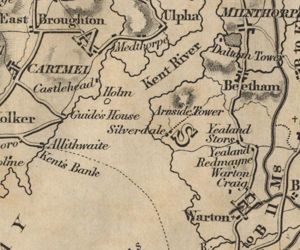 FD02SD47.jpg item:- JandMN : 100.1 Image © see bottom of page |
||
|
|
|||
| evidence:- | old print:- Jopling 1843 item:- horse; cart |
||
| source data:- | Print, sands road, Lancashire Sands, by Charles M Jopling, published by Whittaker
and Co, Ave Maria Lane, London and by Stephen Soulby, Ulverston, Cumberland, 1843.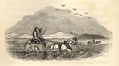 click to enlarge click to enlargeJP1E12.jpg A horse and cart crossing in the waves. On p.60 of a Sketch of Furness and Cartmel, by Charles M Jopling. item:- Armitt Library : A1636.13 Image © see bottom of page |
||
|
|
|||
| evidence:- | old map:- Garnett 1850s-60s H |
||
| source data:- | Map of the English Lakes, in Cumberland, Westmorland and
Lancashire, scale about 3.5 miles to 1 inch, published by John
Garnett, Windermere, Westmorland, 1850s-60s. GAR2SD47.jpg "Road across the Sands at Low Water" double dotted line to Kents Bank  GAR2SD46.jpg from Hest Bank item:- JandMN : 82.1 Image © see bottom of page |
||
|
|
|||
| evidence:- | old text:- Harper 1907 |
||
| source data:- | HP01p086.txt Page 86:- "... to Hest Bank, on the shore of Morecambe Bay, whence old travellers, greatly daring, took a short cut across the treacherous quicksands at low water, to Grange and Cartmel, instead of going the roundabout way of Carnforth and Milnthorpe. Lancashire here is cleft into two separate and distinct portions. Lonsdale south of the sands, and Lonsdale north; a great wedge of Westmoreland coming in between." HP01p087.txt Page 87:- 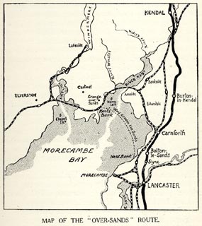 click to enlarge click to enlargeHP01M1.jpg "MAP OF THE "OVER-SANDS" ROUTE." HP01p088.txt Page 88:- "... travellers who wished to pass expeditiously between Lancaster, Furness, and Ulverston had no choice but to make their perilous way "Over-Sands," across the inner bight of Morecambe Bay, at low tide, The alternative was the unwelcome, and anciently the dangerous, one of going the extravagantly long way round by Milnthorpe, Crosthwaite, and Newby Bridge, under Whitbarrow, where the treacherous mosses, almost as dangerous as the sands of the seashore, spread, and where the lawless and desperate cattle-reivers lurked. Confronted with these problems, old-time wayfarers generally chose the sands." "The story of "Lancaster Sands," as they are often called, is romantic and melancholy. The hazardous crossing was made between Hest Bank and Kent's Bank, a distance of eleven miles, over a wet sandy waste that is twelve feet deep in sea-water, at high tide. In these days of railway travel, and since 1864, when the Ulverston and Lancaster Railway was opened, the Over-Sands route is less frequently used, and principally by farmers' carts and by inquisitive tourists; but in all the earlier centuries it was necessary, and great pains were taken to ensure, so far as might humanly be, the safety of travellers across." "The sands are first mentioned by Tacitus, in his history of the second campaign waged by Agricola against the Western Brigantes, the tribes inhabiting Furness and the northern detached district of Lancashire now known as North Lonsdale. The Romans, with their usual combined thoroughness and prudence, appear to have made causeways crossing the estuaries of the Kent, the Leven, and the Duddon, considerable inshore from the exposed Over-Sands route and somewhat on the route of the present railway bridges; but traces of their handiwork are now very few." "..." HP01p089.txt Page 89:- "..." "The more lengthy journey, from Hest Bank to Kent's Bank, was under the especial care of the Priory of Cartmel, which from an early period maintained an official guide who was paid out of a grant made to the Priory from Peter's Pence for the especial purpose of performing this public service. Travellers here also had the benefit of the monks' prayers, which in truth they often needed." "This very necessary office of guide did by no means fall into decay with the dissolution of the monasteries under Henry the Eighth. Provision was made by the expenses being charged to the Duchy of Lancaster: "the Carter over the Kent," as the guide was called, being paid ~20 per annum by the Receiver-General, and the guide across the shorter passage of the Keer being paid ~10. The Carter no doubt performed his duty, but the Sands every now and then claimed their victims. Thus, in the registers of Cartmel may be read the following tragical entries:" ""1576, Sept. 12. One young man buryed, which was drowned in the brodwater."" HP01p090.txt Page 90:- ""1582, Aug. 1, was buryed a son of Leonard Rollinson, of Furness Fell, drowned at the Grainge, the 28th daye of July."" ""1630, Aug. 10, Wm. Best, gent. drowned on Melthorp Sands."" "The registers of Cartmel alone testify to over 120 persons having lost their lives while crossing the channels of these treacherous shores." "The race of secular guides across the Kent began, after the surrender of Cartmel Priory, with Thomas Tempest. Son succeeded father in the office, but they seem soon afterwards to have become Carters; probably having adopted the name from their official title." "The poet Gray, touring the Lake Country in 1769, relates a pathetic story of a family overtaken by the mists half-way across the Sands: "An old fisherman told me, in his dialect, a moving story, how a brother of the trade - a cockler, as he styled him - driving a little cart with his two daughters (women grown) in it, and his wife on horseback following, set out on day to cross the Sands, as they had been frequently used to do (for nobody in the village knew them better than the old man did). When they were about half-way over, a thick fog rose, and as they advanced they found the water much deeper than they expected. The old man was puzzled. He stopped, and said he would go a little way to find some mark he was acquainted with. They stayed awhile for him but in vain. They called aloud, but no reply. At last the young women pressed their mother to think where they were, and go on. She would not leave the place. She wandered about, forlorn and amazed. She would not quit her horse and get into the cart with them. They determined, after much time wasted, to turn back, and gave themselves up to the guidance of their horses. The elder woman was soon washed off, and perished. The girls hung close to their cart, and the horse, sometimes wading and sometimes swimming, brought them back to land alive, but senseless with terror and distress, and unable for many days to give an account of themselves. The bodies of the parents were" HP01p091.txt Page 91:- "found the next ebb, that of the father a very few paces distant from the spot where they had left them."" "The story is still remembered how, in the days when coaches crossed Grange Sands at low water, an outside passenger lost his portmanteau and excitedly jumped down after it, becoming half-engulfed in the treacherous quicksands. He would probably have perished, had the guard, used to the place, not come to his rescue, and pulled him out, with a resounding "cluck," similar to the noise made when drawing a cork." "But a more serious affair was that of 1811, when the Over-Sands coach, the Lancaster stage, was overturned in the Kent Channel, through the horses turning restive. They brought the coach to a stop, and the current washing away the sand under the wheels of one side, the whole affair turned completely over. It was very nearly a tragedy, for there were fifteen passengers, inside and out, flung floundering in the sand and water at a very dangerous place. A young lady, floating on voluminous clothes down the Channel, was grabbed by the guard, and the passengers huddled together on the side of the overturned coach; but all the loose luggage was swept away and lost, and two pointer dogs were drowned. The passengers were brought to land on the backs of the coach-horses, the last being taken off none too soon; for the coach was gradually sinking, and was eventually completely engulfed in the sands." "... A post-chaise was lost and the postboy and one of the horses drowned near Hest Bank in 1821, and in 1825, the Lancaster coach was blown over, midway, and a horse drowned. The passengers were only with difficulty saved. In 1832 the identical coach was sunk in a quicksand. ... disaster occurred to a party of seven farm-hands crossing the Kent Sands to Lancaster in 1857, the year the Furness Railway was opened, and the Over-Sands coach" HP01p092.txt Page 92:- "discontinued. In every case, the bodies were easily found; lending point to the grim story told of an ancient mariner who, asked if guides were ever lost on the sands, answered with simplicity: "I never knew any lost. There's one or two drowned, now and again, but they're generally found when the tide goes out."" "About 1785 a coach was started between Ulverston and Lancaster, going daily across the sands. The scene at its crossing was curious. The Carter, on horseback, headed it, and in its wake generally followed a number of carts and other country vehicles, forming a procession not unlike an Eastern caravan crossing the deserts of Arabia. The Carter's guidance was absolutely necessary, for although the track might at every ebb be beaten out by a multitude, the incoming tide inevitably obliterated every trace of it, and the channels were constantly shifting. A contemporary account says: "The Carter seems a cheerful and pleasant fellow. He wore a rough great-coat and a pair of jack-boots, and was mounted on a good horse, which appeared to have been up to the ribs in water. When we came to him, he recommended us to wait till the arrival of the coach, which was nearly a mile distant, as the tide would then be gone further out. When the coach came up, we took the water in procession, and crossed two channels in one of which the water was up to the horses' bellies. The coach passed over without the least difficulty, being drawn by fine, tall horses. Arrived at the other side, the Carter received our gratuities and we rode on, keeping close to a line of rods which have been planted in the sands to indicate the track. The channels is seldom two days together in the same place. You may make the chart one day, and before the ink is dry it will have shifted."" "A sufficient testimony to the dangers of the sands is found in the fact that those who have known them best have ever been the ones to most dread them and the "cruel crawling tide" that with the shifting of the wind can readily change from a crawl to a hissing seething gallop across the perilous flats." "" "It is the shout of the coming foe," "Ride, ride for thy life, Sir John;" "But still the waters deeper grew" "The wild sea foam rushed on." item:- JandMN : 1055.1 Image © see bottom of page |
||
|
|
|||
| evidence:- | old text:- Harper 1907 |
||
| source data:- | HP01p093.txt Page 93:- "The proper time to attempt the crossing is five hours after high water, but even then only in fine weather. A strong sea-breeze will bring the flood in, fully an hour before the tide-tables; while after heavy rains the crossing is impossible, owing to the flood-water from the rivers permeating the sands in every direction and converting the whole route into one vast quicksand. Never at any time should the stranger attempt the passage without competent assistance." "..." 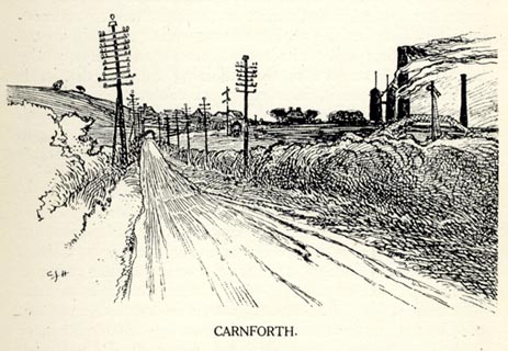 click to enlarge click to enlargeHP0101.jpg "CARNFORTH." item:- JandMN : 1055.2 Image © see bottom of page |
||
|
|
|||
| evidence:- | old text:- Harper 1907 |
||
| source data:- | HP01p093.txt Page 93:- "..." "Turner's picture of the coach crossing the sands is dramatic, but nothing in the way of drama is enacted there now. It is a grey and sullen scene. On the skyline to the left is the tall" HP01p094.txt Page 94:- "ugly tower at Morecambe, and dimly on the right the mountains of Lakeland. The London and North-Western Railway runs along the shore, at its Hest Bank station cutting off proper access, and only by the rarest chance is the Over-Sands route now taken." HP01p095.txt Page 95:- 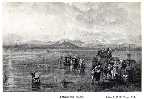 click to enlarge click to enlargeHP0102.jpg "LANCASTER SANDS After J.M.W. Turner, R.A." item:- JandMN : 1055.3 Image © see bottom of page |
||
|
|
|||
| evidence:- | old print:- Waugh 1860 item:- stage coach; coach |
||
| source data:- | Coach setting off from Hest Bank to cross the Lancaster Sands, title page of guide
book, Over Sands to the Lakes, by Edwin Waugh, published by Alexander Ireland and
Co, 22 Market Street, Manchester, and London, 1860.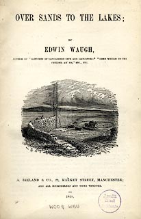 click to enlarge click to enlargeWU01T.jpg The title page has a scene of a coach setting off from Hest Bank, Lancashire to cross the Lancaster Sands to Kents Bank, Grange-over-Sands, Lancashire, drawn by T H Wilson. item:- Armitt Library : A1082 Image © see bottom of page |
||
|
|
|||
| evidence:- | old print:- Waugh 1860 item:- cart |
||
| source data:- | Print, engraving, Over Sands, published by Alexander Ireland and Co, 22 Market Street,
Manchester, 1860.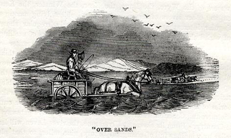 click to enlarge click to enlargeWU0101.jpg On p.4 of Over Sands to the Lakes, by Edwin Waugh. printed at bottom:- ""OVER SANDS."" item:- Armitt Library : A1082.1 Image © see bottom of page |
||
|
|
|||
 BZG20.jpg Crossing the Sands. (taken 6.9.2013) courtesy of Lancaster Museums. |
|||
| The regular stage coach service between Lancaster and Ulverston. |
|||
|
|
|||
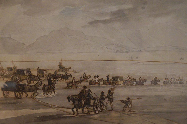 CDE21.jpg The High Sheriff of Lancashire crossing Morecambe Sands, by Thomas Sunderland. (taken 3.6.2015) courtesy of Abbot Hall Art Gallery |
|||
|
|
|||
| places:- | one of several routes Hest Bank, Lancashire Kents Bank, Grange-over-Sands |
||
|
|
|||
Lakes Guides menu.