 Old Cumbria Gazetteer
 |
 |
|
| Piel Pier, Barrow-in-Furness | ||
| Piel Pier | ||
| Piel Station | ||
| site name:- | Furness Railway | |
| site name:- | Roa Island | |
| locality:- | Rampside | |
| civil parish:- | Barrow-in-Furness (formerly Lancashire) | |
| county:- | Cumbria | |
| locality type:- | pier (gone) | |
| locality type:- | railway station (gone) | |
| coordinates:- | SD22766499 (?) | |
| coordinates:- | SD23066499 (?) | |
| 1Km square:- | SD2264 | |
| 10Km square:- | SD26 | |
| SummaryText:- | The pier was a Rampside before there was a railway, and then opened as Piel Station? on Roa Island, 1846; closed 1936. | |
|
|
||
| evidence:- | old map:- OS County Series (Lan 28 1) placename:- Piel Pier |
|
| source data:- | Maps, County Series maps of Great Britain, scales 6 and 25
inches to 1 mile, published by the Ordnance Survey, Southampton,
Hampshire, from about 1863 to 1948. |
|
|
|
||
| evidence:- | old map:- Garnett 1850s-60s H placename:- Piel Pier |
|
| source data:- | Map of the English Lakes, in Cumberland, Westmorland and
Lancashire, scale about 3.5 miles to 1 inch, published by John
Garnett, Windermere, Westmorland, 1850s-60s.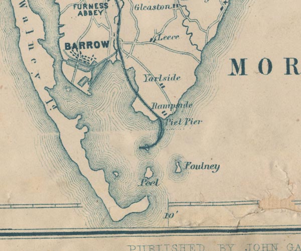 GAR2SD26.jpg "Piel Pier" no symbol; causeway for railway item:- JandMN : 82.1 Image © see bottom of page |
|
|
|
||
| evidence:- | old print:- Gibson 1851 placename:- Piel Pier item:- ship; steamship |
|
| source data:- | Print, engraving, Piel Pier, Rampside, with Barrow in the Distance, from the Sea,
Lancashire, published by J Jackson, Market Place, Ulverston, Lancashire, and by Whittaker
and Co, London, 1851.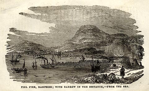 click to enlarge click to enlargeGB05E5.jpg On p.89 of a Hand Book to The Lakes, by James Gibson. printed at bottom:- "PIEL PIER, RAMPSIDE; WITH BARROW IN THE DISTANCE, - FROM THE SEA." item:- Armitt Library : A1131.7 Image © see bottom of page |
|
|
|
||
| evidence:- | old advertisement:- Bemrose 1881 placename:- Piel Pier item:- steamer; paddle steamer; Manxman |
|
| source data:- | Advertisement for the Barrow Steam Navigation Co, paddle steamer Manxman from Barrow-in-Furness,
Lancashire to Douglas, Isle of Man, published by Bemrose and Sons, 23 Old Bailey,
London and Derby, by A B Moss, Carlisle, Cumberland, and by T Wilson, Kendal, Westmorland,
about 1881.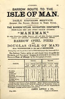 click to enlarge click to enlargeBEM1A4.jpg Included in a Handy Guide to the English Lakes and Shap Spa. item:- JandMN : 455.34 Image © see bottom of page |
|
|
|
||
| evidence:- | old map:- Post Office 1850s-1900s placename:- Piel Pier |
|
| source data:- | Post road maps, General Post Office Circulation Map for England
and Wales, for the General Post Office, London, 1850s-1900s. click to enlarge click to enlargePOF7Cm.jpg "Piel Pier" map date 1909 |
|
|
|
||
| evidence:- | old map:- Post Office 1850s-1900s placename:- Piel Pier |
|
| source data:- | Post road maps, General Post Office Circulation Map for England
and Wales, for the General Post Office, London, 1850s-1900s. click to enlarge click to enlargePF10Cm.jpg "Piel Pier" map date 1892 |
|
|
|
||
| evidence:- | old map:- Post Office 1850s-1900s placename:- Piel Pier |
|
| source data:- | Post road maps, General Post Office Circulation Map for England
and Wales, for the General Post Office, London, 1850s-1900s. click to enlarge click to enlargePOF2Cm.jpg "Piel Pier" map date 1890 |
|
|
|
||
| :- |
images courtesy of the British Postal Museum and Hampshire CC Museums |
|
|
|
||
 Lakes Guides menu.