 Old Cumbria Gazetteer
 |
 |
|
| Lower Man, St John's Castlerigg etc | ||
| Lower Man | ||
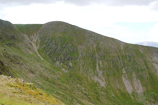
| site name:- | Helvellyn | |
| civil parish:- | St John's Castlerigg and Wythburn (formerly Cumberland) | |
| civil parish:- | Patterdale (formerly Westmorland) | |
| county:- | Cumbria | |
| locality type:- | hill | |
| coordinates:- | NY33741555 | |
| 1Km square:- | NY3315 | |
| 10Km square:- | NY31 | |
| altitude:- | 3035 feet | |
| altitude:- | 925m | |
|
|
||
 BUV02.jpg (taken 20.6.2011) 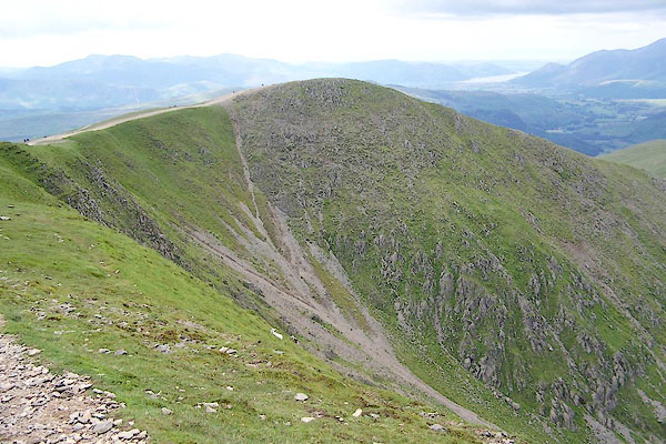 BRB68.jpg (taken 9.7.2009) |
||
|
|
||
| evidence:- | outline view:- Otley 1823 (4th edn 1830) placename:- Helvellyn Low Man |
|
| source data:- | Print, engraving, outline view, The Mountains of Ullswater as seen from Pooley Bridge,
published by Jonathan Otley, Keswick, Cumberland et al, 1830.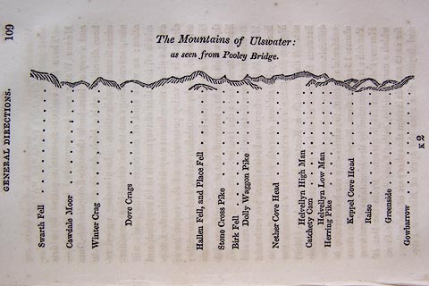 click to enlarge click to enlargeO75E05.jpg p.109 in A Concise Description of the English Lakes, by Jonathan Otley, 4th edition, 1830. "The Mountains of Ulswater: / as seen from Pooley Bridge." "Swarth Fell / Cawdale Moor / Winter Crag / Dove Crags / Hallen Fell, and Place Fell / Stone Cross Pike / Birk Fell / Dolly Waggon Pike / Nether Cove Head / Helvellyn High Man / Catchety Cam / Helvellyn Low Man / Herring Pike / Keppel Cove Head / Raise / Greenside / Gowbarrow" item:- Armitt Library : A1175.5 Image © see bottom of page |
|
|
|
||
| evidence:- | outline view:- Otley 1823 (8th edn 1849) placename:- Helvellyn Low Man |
|
| source data:- | Engraving, outline view of mountains, Ullswater from Pooley Bridge, drawn by T Binns,
engraved by O Jewitt, opposite p.12 of A Descriptive Guide of the English Lakes, by
Jonathan Otley, 8th edition, 1849.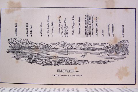 click to enlarge click to enlargeO80E07.jpg item:- Armitt Library : A1180.8 Image © see bottom of page |
|
|
|
||
| evidence:- | outline view:- Otley 1823 (5th edn 1834) placename:- Helvellyn Low Man placename:- Low Man, Helvellyn |
|
| source data:- | Print, woodcut outline view, Mountains of Ullswater, by
Jonathan Otley, Keswick, Cumberland, 1830.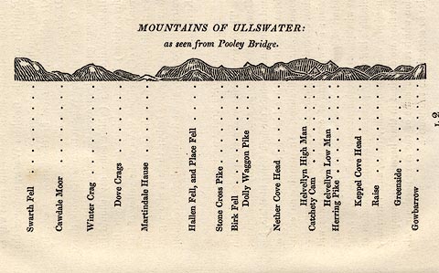 click to enlarge click to enlargeOT2E12.jpg Printed on p.113 of A Concise Description of the English Lakes, by Jonathan Otley, 5th edition, 1834. "MOUNTAINS OF ULLSWATER: as seen from Pooley Bridge." Mountains are listed:- "Swarth Fell / Cawdale Moor / Winter Crag / Dove Crags / Martindale Hause / Hallen Fell, and Place Fell / Stone Cross Pike / Birk Fell / Dolly Waggon Pike / Nether Cove Head / Helvellyn High Man / Catchety Cam / Helvellyn Low Man / Herring Pike / Keppel Cove Head / Raise / Greenside / Gowbarrow" item:- JandMN : 48.13 Image © see bottom of page |
|
|
|
||
| evidence:- | outline view:- Jenkinson 1875 placename:- Helvellyn, Low Man |
|
| source data:- | Print, lithograph, outline view, Panoramic Sketches from Helvellyn, Westmorland, by
Edwin A Pettitt, London, published by Edward Stanford, 55 Charing Cross, London, 1875. click to enlarge click to enlargeJk01E1.jpg "... Helvellyn, Low Man ..." item:- JandMN : 28.5 Image © see bottom of page |
|
|
|
||
| evidence:- | outline view:- Matthew 1866 placename:- Lower Man |
|
| source data:- | Print, engraving, outline view, Helvellyn from above Harrop Tarn, Poney Road from
Wythburn to Whatendlath and Borrowdale, Cumberland, published by J Richardson, Highgate,
Kendal, Westmorland, 1866.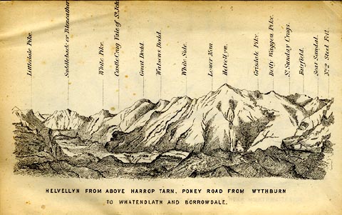 click to enlarge click to enlargeMW1E02.jpg Tipped in before p.1 of The English Lakes, Peaks and Passes, from Kendal to Keswick, by George King Matthew. printed at bottom:- "HELVELLYN FROM ABOVE HARROP TARN, PONEY ROAD FROM WYTHBURN TO WHATENDLATH AND BORROWDALE." printed at caption to mountains:- "... Lower Man. ..." item:- Armitt Library : A1168.2 Image © see bottom of page |
|
|
|
||
 Lakes Guides menu.