 Old Cumbria Gazetteer
 |
 |
|
| Long Churn Cave, North Yorkshire | ||
| Long Churn Cave | ||
| Lower Long Churn Cave | ||
| site name:- | Ingleborough | |
| locality:- | Selside | |
| county:- | North Yorkshire | |
| locality type:- | cave | |
| coordinates:- | SD773757 | |
| 1Km square:- | SD7775 | |
| 10Km square:- | SD77 | |
| SummaryText:- | First complete descent by J Birkbeck and others, 1848. | |
| SummaryText:- | Permission, North Cote, Selside; grade III. | |
| references:- | Brook, A & Brook, D & Davies, G M &Long, M H: 1975: Northern Caves, vol.3 Ingleborough:
Dalesman Books (Clapham, North Yorkshire):: ISBN 0 85206 312 1 |
|
|
|
||
| evidence:- | descriptive text:- West 1778 (11th edn 1821) placename:- Long Churn placename:- Dicken Pot |
|
| source data:- | Guide book, A Guide to the Lakes, by Thomas West, published by
William Pennington, Kendal, Cumbria once Westmorland, and in
London, 1778 to 1821. goto source goto sourceTour to the Caves in the West Riding of Yorkshire, late 18th century Page 273:- "... we went a little higher up the mountain [from Alun Pot], and came to another hiatus, called Long-churn. We descended down till we came to a subterranean brook. We first ascended the cavern down which the stream ran, proceeding in a western direction for (at least as we imagined) a quarter of a mile, till we came to a crevice which admitted us into our native regions. We measured the distance between the two extremities above ground, and found it two hundred and forty-one yards; but it must be nearly double that distance along the passage below, on account of all the turnings and windings. The petrifactions here were the most numerous of any we had yet seen, few people coming either to break them off or deface them. When we were almost arrived at the western extremity, we came to a fine round bason of pellucid water, from three to twelve feet deep, known by the name of Dr. Bannister's Hand-bason. A lofty, spacious, and elegant" goto sourcePage 274:- "dome is placed immediately over it, which nicely corresponds to the hollow receptacle at the bottom. Into this bason a rivulet falls down a steep rock above six feet high, which is very dangerous to get up, and must be done at the expense of a wet skin, except a ladder is taken along with the party, or the waters are less copious than when we were there: there is also some danger lest the adventurer should fall back, and have his bones broken by circumjacent rocks, or be drowned in the doctor's bason. After having surmounted this obstacle, and proceeded some yards farther, we were favoured with an egress into our own element, as was before observed; no unwelcome change, after having been so long excluded from it. After having rested ourselves a little, we returned to the chasm where we first entered Long-churn, and descending again, pursued the rivulet eastward, along another extensive subterranean passage called Dicken-pot, which slopes and winds by degrees till it enters the ghastly and tremendous Alan-pot. We went an hundred and fifty-seven yards along this 'antre-vast,' till we came to a steep rock full twelve feet perpendicular. Here we stopped - a wise consideration. We might have descended perhaps without danger; but the question was, how were we to get up again; which, without ropes or a ladder, would be totally impracticable. At the far end was an elegant lofty dome, called by the country people St. Paul's. There is no doubt but if we had ventured further we might have come to Alan-pot, at least so near as either to have seen the water that stagnates at its bottom, or the light that is admitted into this gaping monster of nature." |
|
|
|
||
| evidence:- | descriptive text:- Otley 1823 (8th edn 1849) placename:- Long Church |
|
| source data:- | Guide book, A Concise Description of the English Lakes, the
mountains in their vicinity, and the roads by which they may be
visited, with remarks on the mineralogy and geology of the
district, by Jonathan Otley, published by the author, Keswick,
Cumberland now Cumbria, by J Richardson, London, and by Arthur
Foster, Kirkby Lonsdale, Cumbria, 1823; published 1823-49,
latterly as the Descriptive Guide to the English Lakes. goto source Page 202:- "LONG CHURN is a little further up the mountain to the right of Alum Pot. All the beautiful stalactites with which this cavern so much abounded, have been removed by cart loads to build artificial grottos." |
|
|
|
||
| evidence:- | descriptive text:- Balderston c1890 placename:- Long Churn Cave item:- stalactite |
|
| source data:- | Book, Ingleton, Bygone and Present, by Robert R and Margaret
Balderston, published by Simpkin, Marshall and Co, London, and
by Edmndson and Co, 24 High Street, Skipton, Yorkshire, about
1890. goto source page 53:- "..." "Long Churn and Dicken Pot Caves." "About one hundred yards north north-west of Alum Pot, is Long Churn Cave, and nearly a quarter-of-a-mile further is the upper mouth of Dicken Pot. Long Churn has years ago been robbed of the stalactites which it once so plentifully contained. It is a cave of engulfment, or one which has to be entered along with the stream that flows underground towards Alum Pot, and is of fair size. The passage in its earlier portion is by no means lofty." "Dicken Pot is formed by a branch of the same stream in the higher part of its course, ..." |
|
|
|
||
| evidence:- | old map:- Balderston c1890 map placename:- Long Churn Cave |
|
| source data:- | Map, the hills in the Ingleton area, probably by Robert R
Balderston, engraved by Goodall and Suddick, Leeds, West
Yorkshire, about 1890.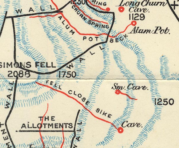 BS1SD77S.jpg "Long Churn Cave" item:- private collection : 27.1 Image © see bottom of page |
|
|
|
||
Lakes Guides menu.