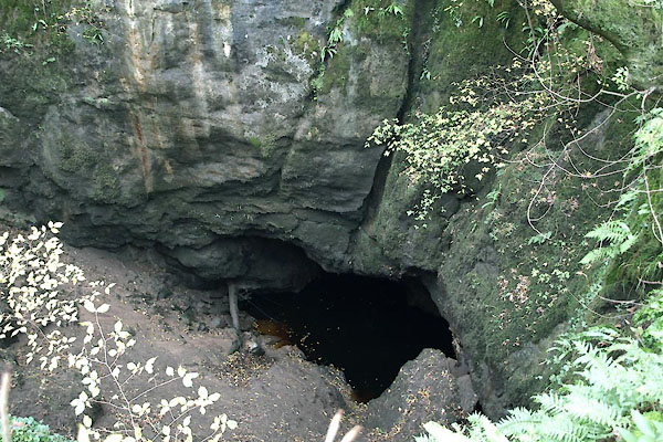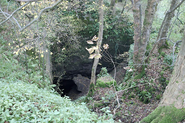


BTT04.jpg (taken 29.10.2010)

BTT03.jpg (taken 29.10.2010)
 goto source
3rd edn addenda, page 229:- "..."
"Nigh the Chapel in the dale, ... I met with three caverns that are totally unlike any in this island, tho' caverns are common in all limestone countries. The first (nigh the chapel) is a pit sinking from an even surface about forty yards into the ground, and is about the same number of yards in diameter. At the bottom is a deep pool of water, from whence issues a subterraneous brook, but through so narrow a passage, that in wet weather, the cavern fills up, and overflows its brim.- ..."
placename:- Hurtlepot
 goto source
Tour to the Caves in the West Riding of Yorkshire, late 18th century
Page 255:- "..."
"The first curiosity we were conducted to [from Chapel-le-Dale], was Hurtlepot, about eighty yards above the chapel. It is a round, deep hole, between thirty and forty yards diameter, surrounded with rocks almost on all sides, between thirty and forty feet perpendicular above a deep black water in a subterranean cavity at its bottom. All round the top of this horrid place are trees, which grow secure from the axe; their branches almost meet in the centre, and spread a gloom over a chasm dreadful enough of itself without being heightened with any additional appendages. It was indeed one of the most dismal prospect we had yet been presented with: almost every sense was affected in such an uncommon manner, as to excite ideas of a nature truly horribly sublime. When ever we threw in a pebble, or spoke a word, our ears were assailed with a dismal hollow sound, our nostrils were affected with an uncommon complication of strong smells, from the ramps and other weeds that grew plentifully about its sides, and the rank vapours that exhaled from the black abyss beneath. The descent of Eneas into the infernal regions came again fresh into my imagination, and the following passage out of Virgil obtruded itself on my memory,-"
"Spelunca alta fuit, vastoque immanis hiatu / Scrupea, tuta lacu nigro nemorumque tenebris; / Quam super haud ulloe poterant impune volantes / Tendere iter pennis: talis sese halitus atris / Faucibus effundens supera ad convexa ferebat; / Unde locum Graii dixerunt nomine Avernum."
"Eneid, b.6. l.237."
 goto source
Page 256:- "Deep was the cave, and downwards as it went / From the wide mouth, a rocky, rough descent: / And here the' access a gloomy grove defends: / And there the unnavigable lake extends, / O'er whose unhappy waters, void of light, / No bird presumes to steer his airy flight: / From hence the Grecian bards their legends make, / And give the name Avernus to the lake."
"Dryden."
"After viewing for some time, with horror and astonishment, its dreadful aspect from the top, we were emboldened to descend, by a steep and slippery passage, to the margin of this Avernian lake. What its depth is, we could not learn; but from the length of time the sinking stones we threw in continued to send up bubbles from the black abyss, we concluded it to be very profound. How far it extended under the huge pendant rocks, we could get no information of, a subterranean embarkation having never yet been fitted out for discoveries. In great floods, we were told, this pot runs over: some traces of it then remained on the grass. While we stood at the bottom, the awful silence was broken every three or four seconds by drops of water falling into the lake from the rocks above in different solemn keys. The sun shining on the surface of the water, illuminated the bottom of the superincumbent rocks, only a few feet above; which being viewed by reflection in the lake, caused a curious deception, scarcely any where to be met with - they appeared at the like distance below its surface, in form of a rugged bottom: but, alas! how fatal would be the consequence, if any adventurer should attempt to wade across the abyss on this shadow of a foundation! - While we were standing on the margin of this subterranean lake, we were suddenly astonished with a most uncommon noise on the surface of the water, under the pendant rocks. It is called by the country people Hurtlepot boggard, and sometimes the fairy churn, as a churn it resembles. It is no doubt frightful to them, and would have been so to us, if we had not been apprized of the cause: we found it was effected by the glutting of the surface of the water"
 goto source
Page 257:- "against the bottom of some rocks, or passages worn into them to a considerable distance, when it was descending after rain, as then happened to be the case.- This deep is not without its inhabitants: large black trouts are frequently caught in it by the neighbouring people. Botanists find here some rare and curious plants."
"On our return from the margin of this Avernian lake, we found the observation of the poet Virgil very applicable,-"
"... Fascilis descensus Averni: / Noctes atque dies patet atri janua Ditis; / Sed revocare gradum, superasque evadere ad auras, / Hoc opus, hic labor est."
"The gates of hell are open night and day; / Smooth the descent, and easy is the way; / But to return, and view the cheerful skies - / In this the task and mighty labour lies."
"Dryden."
 goto source
Page 258:- "... The delicate and timid may neither be afraid of their persons or clothes, if they have no mind to descend: they may stand safe on the margin of either Hurtlepot, Ginglepot, or Weathercoat-cave. They will there see enough to astonish them, and imagination will supply the rest."
 goto source
Page 259:- "[in Weathercoat cave] ... The water sinks as its (sic) falls amongst the rocks and pebbles, running by a subterranean passage about a mile, when it appears again by the side of the turnpike road, visiting in its way the other caverns of Ginglepot and Hurtlepot. ..."
placename:- Hurtle Pot
 goto source
Page 199:- "..."
"HURTLE POT is a dismal, gloomy hole surrounded on all sides with perpendicular rocks, which overhang a deep dark pool of water. The descent to the edge of this pool is by a steep and slippery path; and whenever you speak, or throw in a pebble, your ears are assailed by uncommon noises, whilst your nostrils are affected by unpleasant odours from the ramps and other weeds that grow plentifully about its sides, and the rank vapours that exhale from the black abyss beneath. The depth of the pool, by accurate measurement, is 27 feet. A curious phenomenon occurs in this cavern, caused by the glutting of water against the surface of rocks, after heavy rains. A singular noise is heard to proceed from the surface of the water, which the country folks call 'The Hurtlepot Boggart,' or the 'Fairy Churn.'"
placename:- Hurtle Pot
placename:- Fairy Churn
placename:- Hurtle Pot Boggart
item:- glutting
 goto source
page 37:- "Hurtle Pot."
"Here is another dismal hole overshadowed by impending rocks, beneath whose shelving recesses a deep and murky pool pulsates with a hollow glutting sound, and to which an entry can be obtained by a narrow opening on the southern side, trending downwards with a steep and noisome slope. The air is heavy with the repugnant odours of the broad-leaved allium - ramsons - rendered more pungent by the vapours exhaling from the filthy bottom, or the cavernous passages wherein they have been pent. The depth of the pool is twenty-three feet, the height of the rock fifty-eight above the water, and the distance from Chapel-le-Dale Church about seventy yards. After a heavy downfall of rain the glutting sound, to which allusion has already been made, is most marked. This intermittent throbbing sound, issuing whence the surface of the water and the hidden ledges meet, is called the Fairy Churn, or Hurtle Pot Boggart, and may at other times be much increased by throwing a heavy stone into the ebon depths. Steps have recently been cut in the soft soil, and a hand-rail erected so as to make the descent more easy; the charge for admittance is threepence, and refreshments can be had at the house of Mrs. Morphet."
placename:- Hurtle Pot

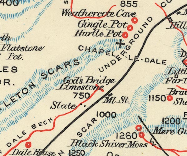
BS1SD77I.jpg
"Hurtle Pot"
item:- private collection : 27.1
Image © see bottom of page
