 Old Cumbria Gazetteer
 |
 |
|
| Howgill Tongue, Underskiddaw | ||
| Howgill Tongue | ||
| site name:- | Jenkin Hill | |
| civil parish:- | Underskiddaw (formerly Cumberland) | |
| county:- | Cumbria | |
| locality type:- | hill | |
| coordinates:- | NY27162686 (etc) | |
| 1Km square:- | NY2726 | |
| 10Km square:- | NY22 | |
|
|
||
| evidence:- | old map:- OS County Series (Cmd 56 14) placename:- Howgill Tongue |
|
| source data:- | Maps, County Series maps of Great Britain, scales 6 and 25
inches to 1 mile, published by the Ordnance Survey, Southampton,
Hampshire, from about 1863 to 1948. |
|
|
|
||
| evidence:- | outline view:- Otley 1823 (8th edn 1849) placename:- Howgill Tongue |
|
| source data:- | Engraving, outline view of mountains, Skiddaw, and Saddleback ... as seen on entering
Keswick from the South, drawn by T Binns, engraved by O Jewitt, opposite p.46 of A
Descriptive Guide of the English Lakes, by Jonathan Otley, 8th edition, 1849.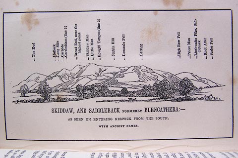 click to enlarge click to enlargeO80E16.jpg item:- Armitt Library : A1180.17 Image © see bottom of page |
|
|
|
||
| evidence:- | outline view:- Otley 1823 (5th edn 1834) |
|
| source data:- | Print, woodcut outline view, Skiddaw and Saddleback, by Jonathan Otley, Keswick, Cumberland,
1830.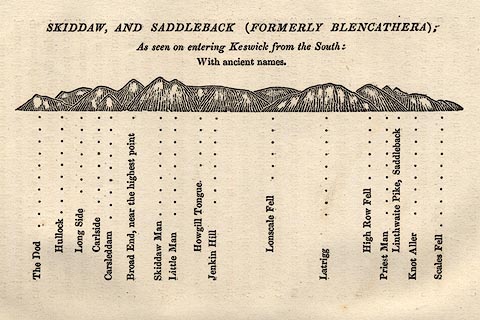 click to enlarge click to enlargeOT2E08.jpg Printed on p.49 of A Concise Description of the English Lakes, by Jonathan Otley, 5th edition, 1834. "SKIDDAW, AND SADDLEBACK (FORMERLY BLENCATHRA): As seen entering Keswick from the South: With ancient names." "The Dod / Hullock / Long Side / Carlside / Carsleddam / Broad End, near the highest point / Skiddaw Man / Little Man / Howgill Tongue / Jenkin Hill / Lonscale Fell / Latrigg / High Row Fell / Priest Man / Linthwaite Pike, Saddleback / Knot Aller / Scales Fell" item:- JandMN : 48.9 Image © see bottom of page |
|
|
|
||
 Lakes Guides menu.