 Old Cumbria Gazetteer
 |
 |
|
| Hawking Hall, Middleton | ||
| Hawking Hall | ||
| civil parish:- | Middleton (formerly Westmorland) | |
| county:- | Cumbria | |
| locality type:- | buildings | |
| coordinates:- | SD61988578 | |
| 1Km square:- | SD6185 | |
| 10Km square:- | SD68 | |
|
|
||
| evidence:- | old map:- OS County Series (Wmd 43 8) placename:- Hawking Hall |
|
| source data:- | Maps, County Series maps of Great Britain, scales 6 and 25
inches to 1 mile, published by the Ordnance Survey, Southampton,
Hampshire, from about 1863 to 1948. |
|
|
|
||
| evidence:- | hearth tax returns:- Hearth Tax 1675 placename:- Hawkins |
|
| source data:- | Records, hearth tax survey returns, Westmorland, 1674/75. "Hawkins" in "Middleton in Lonsdale ward" |
|
|
|
||
| evidence:- | old map:- Morden 1695 (Wmd) placename:- Haukin Hale |
|
| source data:- | Map, hand coloured engraving, Westmorland, scale about 2.5 miles to 1 inch, by Robert
Morden, published by Abel Swale, the Unicorn, St Paul's Churchyard, Awnsham, and John
Churchill, the Black Swan, Paternoster Row, London, 1695.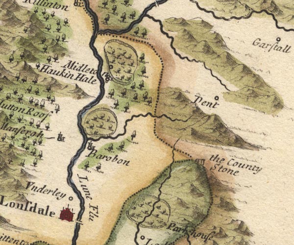 MD10SD68.jpg "Haukin Hale" Circle, tower. item:- JandMN : 24 Image © see bottom of page |
|
|
|
||
| evidence:- | old map:- Badeslade 1742 placename:- Haukul Hall |
|
| source data:- | Map, uncoloured engraving, A Map of Westmorland North from
London, scale about 10 miles to 1 inch, with descriptive text,
by Thomas Badeslade, London, engraved and published by William
Henry Toms, Union Court, Holborn, London, 1742. click to enlarge click to enlargeBD12.jpg "Haukul Hall" circle, italic lowercase text; village, hamlet or locality item:- Dove Cottage : 2007.38.62 Image © see bottom of page |
|
|
|
||
| evidence:- | old map:- Simpson 1746 map (Wmd) placename:- Haukut Hall |
|
| source data:- | Map, uncoloured engraving, Westmorland, scale about 8 miles to 1
inch, printed by R Walker, Fleet Lane, London, 1746.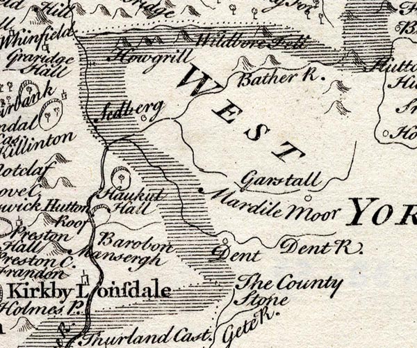 SMP2SDU.jpg "Haukut Hall" Building in a park. item:- Dove Cottage : 2007.38.59 Image © see bottom of page |
|
|
|
||
| evidence:- | old map:- Bowen and Kitchin 1760 placename:- Haukul Hall |
|
| source data:- | Map, hand coloured engraving, A New Map of the Counties of
Cumberland and Westmoreland Divided into their Respective Wards,
scale about 4 miles to 1 inch, by Emanuel Bowen and Thomas
Kitchin et al, published by T Bowles, Robert Sayer, and John
Bowles, London, 1760.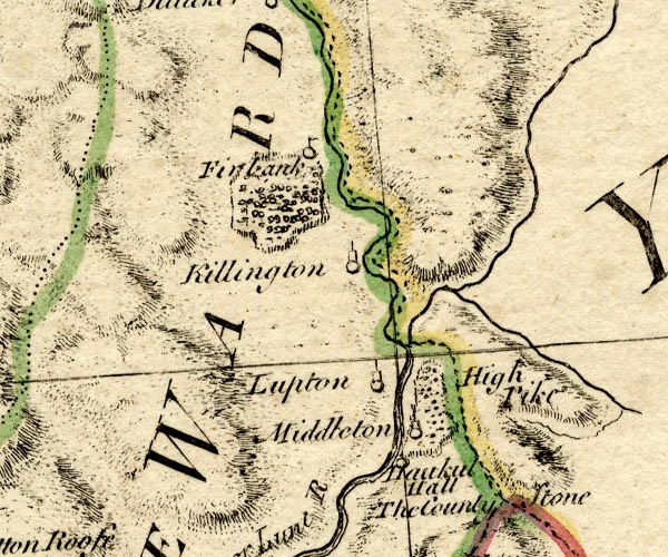 BO18SD69.jpg "[H]aukul Hall" circle and ? item:- Armitt Library : 2008.14.10 Image © see bottom of page |
|
|
|
||
| evidence:- | old map:- Jefferys 1770 (Wmd) placename:- Hougin Hall |
|
| source data:- | Map, 4 sheets, The County of Westmoreland, scale 1 inch to 1
mile, surveyed 1768, and engraved and published by Thomas
Jefferys, London, 1770.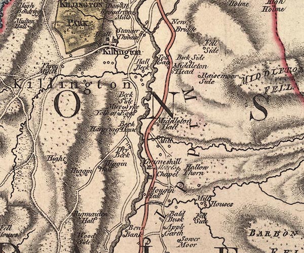 J5SD68NW.jpg "Hougin Hall" circle, labelled in italic lowercase text; settlement, farm, house, or hamlet? item:- National Library of Scotland : EME.s.47 Image © National Library of Scotland |
|
|
|
||
| evidence:- | old map:- Cary 1789 (edn 1805) placename:- Hougin Hall |
|
| source data:- | Map, uncoloured engraving, Westmoreland, scale about 2.5 miles
to 1 inch, by John Cary, London, 1789; edition 1805.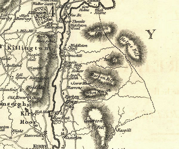 CY24SD68.jpg "Hougin Hall" block/s, labelled in italic lowercase; house, or hamlet item:- JandMN : 129 Image © see bottom of page |
|
|
|
||
| evidence:- | possibly old map:- Cooke 1802 placename:- Hougin Hall |
|
| source data:- | Map, Westmoreland ie Westmorland, scale about 12 miles to 1
inch, by George Cooke, 1802, published by Sherwood, Jones and
Co, Paternoster Road, London, 1824. click to enlarge click to enlargeGRA1Wd.jpg "Houg[in] Hall" building item:- Hampshire Museums : FA2000.62.4 Image © see bottom of page |
|
|
|
||
| evidence:- | possibly old map:- Hall 1820 (Wmd) placename:- Hougin Hall |
|
| source data:- | Map, hand coloured engraving, Westmoreland ie Westmorland, scale
about 14.5 miles to 1 inch, by Sidney Hall, London, 1820,
published by Samuel Leigh, 18 Strand, London, 1820-31. click to enlarge click to enlargeHA18.jpg "Hougin Hall" circle; house item:- Armitt Library : 2008.14.58 Image © see bottom of page |
|
|
|
||
| evidence:- | old map:- Ford 1839 map placename:- Houghin Hall |
|
| source data:- | Map, uncoloured engraving, Map of the Lake District of
Cumberland, Westmoreland and Lancashire, scale about 3.5 miles
to 1 inch, published by Charles Thurnam, Carlisle, and by R
Groombridge, 5 Paternoster Row, London, 3rd edn 1843.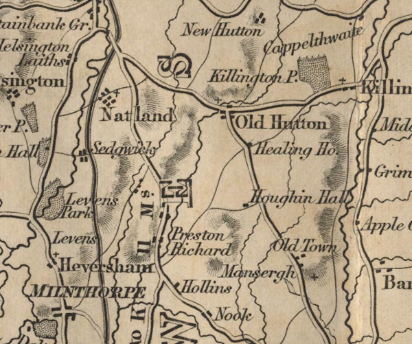 FD02SD58.jpg "Houghin Hall" item:- JandMN : 100.1 Image © see bottom of page |
|
|
|
||
 Lakes Guides menu.