 Old Cumbria Gazetteer
 |
 |
|
| Hartsop Dodd, Patterdale | ||
| Hartsop Dodd | ||
| civil parish:- | Patterdale (formerly Westmorland) | |
| county:- | Cumbria | |
| locality type:- | hill | |
| coordinates:- | NY411118 | |
| 1Km square:- | NY4111 | |
| 10Km square:- | NY41 | |
| altitude:- | 2028 feet | |
| altitude:- | 618m | |
|
|
||
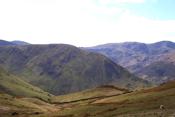
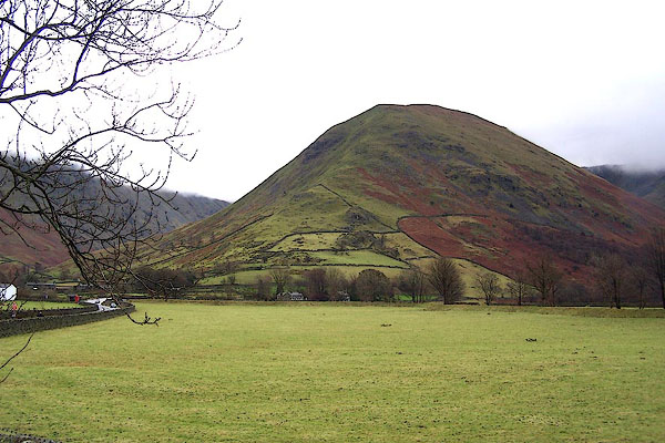 BLK68.jpg From Cow Bridge, Hartsop. (taken 5.12.2005) 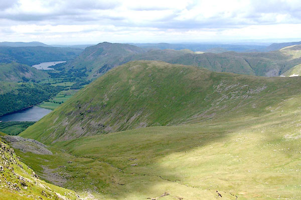 BQT19.jpg (taken 9.6.2009) |
||
|
|
||
| evidence:- | old map:- Jefferys 1770 (Wmd) placename:- Dod Hill |
|
| source data:- | Map, 4 sheets, The County of Westmoreland, scale 1 inch to 1
mile, surveyed 1768, and engraved and published by Thomas
Jefferys, London, 1770.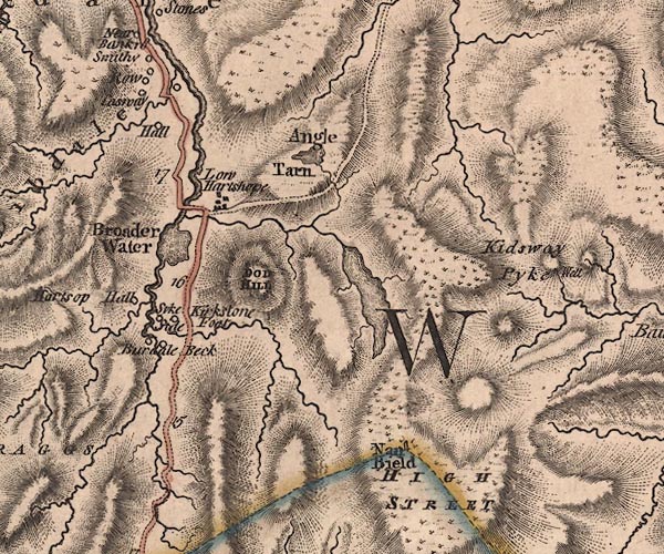 J5NY41SW.jpg "DOD HILL" hill hachuring; hill or mountain item:- National Library of Scotland : EME.s.47 Image © National Library of Scotland |
|
|
|
||
| evidence:- | old map:- Cary 1789 (edn 1805) placename:- Dod Hill |
|
| source data:- | Map, uncoloured engraving, Westmoreland, scale about 2.5 miles
to 1 inch, by John Cary, London, 1789; edition 1805.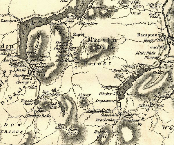 CY24NY41.jpg "Dod Hill" hill hachuring item:- JandMN : 129 Image © see bottom of page |
|
|
|
||
| evidence:- | outline view:- Otley 1823 (4th edn 1830) placename:- Hartshop Dod |
|
| source data:- | Print, engraving, outline view, Mountains of Patterdale as seen from the Slate Quarry
on Place Fell, published by Jonathan Otley, Keswick, Cumberland et al, 1830.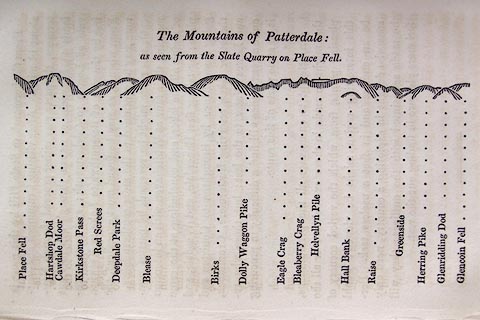 click to enlarge click to enlargeO75E10.jpg p.137 in A Concise Description of the English Lakes, by Jonathan Otley, 4th edition, 1830. "The Mountains of Patterdale: / as seen from the Slate Quarry on Place Fell." "Place Fell / Hartshop Dod / Cawdale Moor / Kirkstone Pass / Red Screes / Deepdale Park / Blease / Birks / Dolly Waggon Pike / Eagle Crag / Bleaberry Pike / Helvellyn Pile / Hall Bank / Raise / Greenside / Herring Pike / Glenridding Dod / Glencoin Fell" item:- Armitt Library : A1175.10 Image © see bottom of page |
|
|
|
||
| evidence:- | outline view:- Otley 1823 (8th edn 1849) placename:- Hartsop Dod |
|
| source data:- | Engraving, outline view of mountains, Mountains of Patterdale from the Slate Quarry
on Place Fell, drawn by T Binns, engraved by O Jewitt, opposite p.14 of A Descriptive
Guide of the English Lakes, by Jonathan Otley, 8th edition, 1849.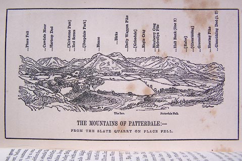 click to enlarge click to enlargeO80E08.jpg item:- Armitt Library : A1180.9 Image © see bottom of page |
|
|
|
||
| evidence:- | outline view:- Otley 1823 (5th edn 1834) placename:- Hartsop Dod |
|
| source data:- | Print, woodcut outline view, The Mountains of Patterdale, by
Jonathan Otley, Keswick, Cumberland, 1830.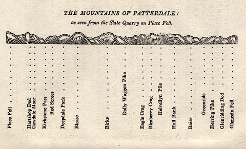 click to enlarge click to enlargeOT2E02.jpg Printed on p.11 of A Concise Description of the English Lakes, by Jonathan Otley, 5th edition, 1834. "THE MOUNTAINS OF PATTERDALE: as seen from the Slate Quarry on Place Fell." "Place Fell / Hartsop Dod / Cawdale Moor / Kirkstone Pass / Red Screes / Deepdale Park / Blease / Birks / Dolly Waggon Pike / Eagle Crag / Bleaberry Crag / Helvellyn Pile / Hall Bank / Raise / Greenside / Herring Pike / Glenridding Dod / Glencoin Fell" item:- JandMN : 48.3 Image © see bottom of page |
|
|
|
||
| evidence:- | outline view:- Black 1856 (23rd edn 1900) placename:- Hartsop Dod |
|
| source data:- | Print, lithograph, Outline Views, Ullswater - Mountains as seen a little on the Matterdale
Road near Lyulph's Tower on Ullswater, and Mountains as seen at the Slate Quarry at
Blowick on Ullswater, by J Flintoft, Keswick, Cumberland, engraved by R Mason, Edinburgh,
Lothian, about 1900.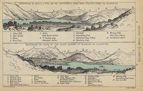 click to enlarge click to enlargeBC08E2.jpg "... 2 Hartsop Dod ..." item:- JandMN : 37.8 Image © see bottom of page |
|
|
|
||
| evidence:- | outline view:- Black 1841 (3rd edn 1846) placename:- Hartsop Dod |
|
| source data:- | Print, engraving, outline view, Mountains as seen a little on the Matterdale Road
near Lyulph's Tower on Ulleswater, and Mountains as seen at the Slate Quarry at Blowick
on Ulleswater, by J Flintoft, Keswick, Cumberland, engraved by R Mason, Edinburgh,
Lothian, about 1846.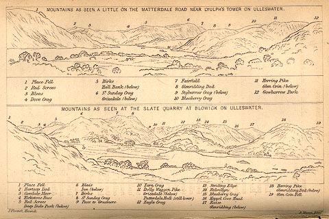 click to enlarge click to enlargeBC02E9.jpg "... 2 Hartsop Dod ..." item:- JandMN : 32.15 Image © see bottom of page |
|
|
|
||
 BNO88.jpg (taken 18.4.2007) 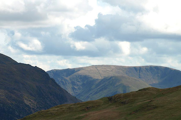 BPC86.jpg Place Fell and Hartsop Dodd. (taken 2.5.2008) |
||
|
|
||
 Lakes Guides menu.