 Old Cumbria Gazetteer
 |
 |
|
| Great Dun Fell, Milburn | ||
| Great Dun Fell | ||
| locality:- | Milburn Forest | |
| civil parish:- | Milburn (formerly Westmorland) | |
| county:- | Cumbria | |
| locality type:- | hill | |
| coordinates:- | NY710321 (etc) | |
| 1Km square:- | NY7132 | |
| 10Km square:- | NY73 | |
| altitude:- | 2780 feet | |
| altitude:- | 847m | |
|
|
||
| evidence:- | old map:- OS County Series (Wmd 5 4) placename:- Great Dun Fell placename:- Dun Fell, Great |
|
| source data:- | Maps, County Series maps of Great Britain, scales 6 and 25
inches to 1 mile, published by the Ordnance Survey, Southampton,
Hampshire, from about 1863 to 1948. |
|
|
|
||
| evidence:- | perhaps old map:- Morden 1695 (Wmd) placename:- Dun Fell |
|
| source data:- | Map, hand coloured engraving, Westmorland, scale about 2.5 miles to 1 inch, by Robert
Morden, published by Abel Swale, the Unicorn, St Paul's Churchyard, Awnsham, and John
Churchill, the Black Swan, Paternoster Row, London, 1695.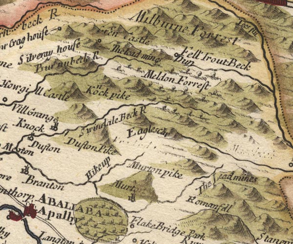 MD10NY72.jpg "Fell / Dun" Circle. item:- JandMN : 24 Image © see bottom of page |
|
|
|
||
| evidence:- | old map:- Jefferys 1770 (Wmd) placename:- Dunn Fell |
|
| source data:- | Map, 4 sheets, The County of Westmoreland, scale 1 inch to 1
mile, surveyed 1768, and engraved and published by Thomas
Jefferys, London, 1770.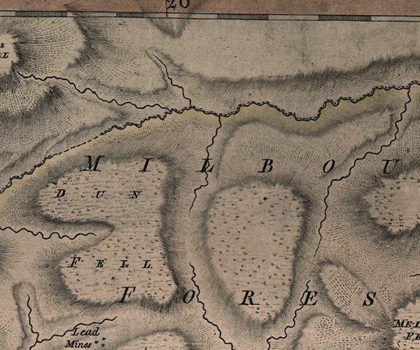 J5NY73SW.jpg "DUNN FELL" hill hachuring; hill or mountain item:- National Library of Scotland : EME.s.47 Image © National Library of Scotland |
|
|
|
||
| hearsay:- |
During the WSW gales of 15 January 1968, a gust of 134 mph was recorded on this hill. |
|
|
|
||
 Lakes Guides menu.