 Old Cumbria Gazetteer
 |
 |
|
||||||||||||||||||||||||
| Goat Scar, Longsleddale | ||||||||||||||||||||||||||
| Goat Scar | ||||||||||||||||||||||||||
| civil parish:- | Longsleddale (formerly Westmorland) | |||||||||||||||||||||||||
| county:- | Cumbria | |||||||||||||||||||||||||
| locality type:- | rocks | |||||||||||||||||||||||||
| coordinates:- | NY47660684 (etc) | |||||||||||||||||||||||||
| 1Km square:- | NY4706 | |||||||||||||||||||||||||
| 10Km square:- | NY40 | |||||||||||||||||||||||||
|
|
||||||||||||||||||||||||||
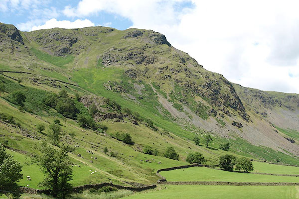 BRB84.jpg (taken 19.7.2009) 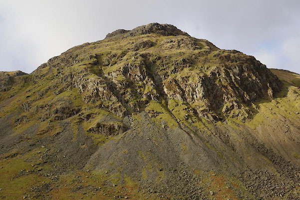 BZS98.jpg (taken 28.12.2013) |
||||||||||||||||||||||||||
|
|
||||||||||||||||||||||||||
| evidence:- | old map:- OS County Series (Wmd 27 2) placename:- Goat Scar |
|||||||||||||||||||||||||
| source data:- | Maps, County Series maps of Great Britain, scales 6 and 25
inches to 1 mile, published by the Ordnance Survey, Southampton,
Hampshire, from about 1863 to 1948. |
|||||||||||||||||||||||||
|
|
||||||||||||||||||||||||||
| evidence:- | old map:- Jefferys 1770 (Wmd) placename:- Codka |
|||||||||||||||||||||||||
| source data:- | Map, 4 sheets, The County of Westmoreland, scale 1 inch to 1
mile, surveyed 1768, and engraved and published by Thomas
Jefferys, London, 1770.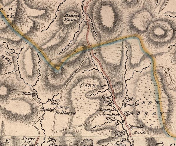 J5NY40NE.jpg "CODKA" hill hachuring; hill or mountain item:- National Library of Scotland : EME.s.47 Image © National Library of Scotland |
|||||||||||||||||||||||||
|
|
||||||||||||||||||||||||||
| evidence:- | old map:- Hodgson 1828 placename:- Goatka placename:- Goat Crag |
|||||||||||||||||||||||||
| source data:- | Map, hand coloured engraving, 4 sheets mounted together on linen and rolled, Plan
of the County of Westmorland, scale about 1.25 inches to 1 mile, by Thomas Hodgson,
engraved by W R Gardner, Harpur Street, London, published by Thomas Hodgson, Lancaster,
and perhaps by C Smith, 172 Strand, London,1828.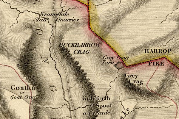 HDG6lsl4.jpg map courtesy of Mark Cropper "Goatka or Goat Crag" item:- private collection : 371 Image © see bottom of page |
|||||||||||||||||||||||||
|
|
||||||||||||||||||||||||||
| evidence:- | descriptive text:- Ford 1839 (3rd edn 1843) placename:- Goat Scar item:- altitude, Goat Scar |
|||||||||||||||||||||||||
| source data:- | Guide book, A Description of Scenery in the Lake District, by
Rev William Ford, published by Charles Thurnam, Carlisle, by W
Edwards, 12 Ave Maria Lane, Charles Tilt, Fleet Street, William
Smith, 113 Fleet Street, London, by Currie and Bowman,
Newcastle, by Bancks and Co, Manchester, by Oliver and Boyd,
Edinburgh, and by Sinclair, Dumfries, 1839. goto source goto sourcePage 178:- "ELEVATION OF THE MOUNTAINS," "ACCORDING TO DIFFERENT AUTHORITIES."
|
|||||||||||||||||||||||||
|
|
||||||||||||||||||||||||||
| evidence:- | old map:- OS 1881-82 New Series (outline edition) placename:- Goat Scar |
|||||||||||||||||||||||||
| source data:- | Map, engraving, area north of Kendal, Westmorland, New Series
one inch map, outline edition, sheet 39, scale 1 inch to 1 mile,
published by the Ordnance Survey, Southampton, Hampshire,
1881-82.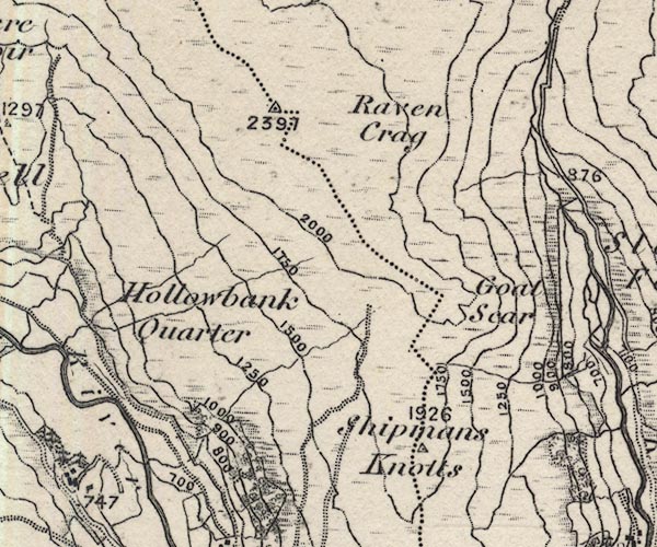 O21NY40T.jpg , "Goat Scar" item:- JandMN : 61 Image © see bottom of page |
|||||||||||||||||||||||||
|
|
||||||||||||||||||||||||||
| evidence:- | old print:- Watson 1894 |
|||||||||||||||||||||||||
| source data:- | View of upper Longsleddale including Sadgill, Goat Scar and Buckbarrow, in The Annals
of a Quiet Valley, by A Country Parson edited by John Watson, published by J M Dent
and Co, London, 1894.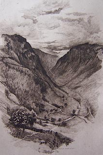 click to enlarge click to enlargeWT1E01.jpg "BERTHA NEWCOMBE" item:- Kendal Library : 5 Image © see bottom of page |
|||||||||||||||||||||||||
|
|
||||||||||||||||||||||||||
| evidence:- | descriptive text:- Wilson 1912 |
|||||||||||||||||||||||||
| source data:- | Guide book, Longsleddale, by F M Wilson, published by T Wilson,
Kendal, Westmorland, 1912. WILSON1.txt "Towards the head of the valley the dale grows more narrow, rocky, and abrupt, till you think you can penetrate no further. As we leave the church, it assumes a wild, lonely and most solemn aspect, dividing Longsleddale from Mardale, with the grim and ghastly 'Goat Scar' on the left ..." "..." "The names of the hills round about Longsleddale still speak of a race of animals which lived in these dales at no distant date, Goat Scar, Ravens Crag, Buckbarrow, Buck Crags, and Catbarrow. It is only a few years since the last of the large vulture tribe was shot somewhere about Grey Crag." |
|||||||||||||||||||||||||
|
|
||||||||||||||||||||||||||
| evidence:- | descriptive text:- placename:- Goatscar item:- hound; fox hound; fox; hunting; Coniston Hounds |
|||||||||||||||||||||||||
| source data:- | Clapham, Richard: 1920: Foxhunting on the Lakeland Fells: Longmans, Green and Co (London) "In December, 1919, the Coniston Hounds had a very fast hunt from a covert above Staveley
village. Hounds finally drove their fox to the head of the Longsleddale valley, where
it 'benked' on a ledge on Goatscar. It had been a late find, and when the huntsmen
arrived on the scene, darkness was fast drawing in. The fox was at last made to vacate
his dangerous resting-place, and he scrambled down a precipitous chimney on the face
of the towering crag. Then ensued a wild and exciting scene, such as can only be experienced
on the fells. The chimney was a dangerous place for hounds, with a fox dodging his
way through them. Twice they had hold of him, but he wrenched free, and got clear
at the chimney's foot, where he soon outdistanced them across the rough scree-bed.
One of the hounds fell a matter of fifty feet, but beyond being temporarily shaken
appeared little the worse, and quickly resumed the chase. Snow was lying thickly on
the tops, and it was sufficiently light to see the fox climbing out for the summit
of the crag again, where he ran through the roughest of the ground near the fell head,
and finally disappeared on the wide top of Harter Fell. Hounds followed him, and we
saw them no mor that night." |
|||||||||||||||||||||||||
|
|
||||||||||||||||||||||||||
| evidence:- | old postcard:- |
|||||||||||||||||||||||||
| source data:- | Postcard, sepia, photograph of Goatscar in the Si-Ko series, 1920s-30s?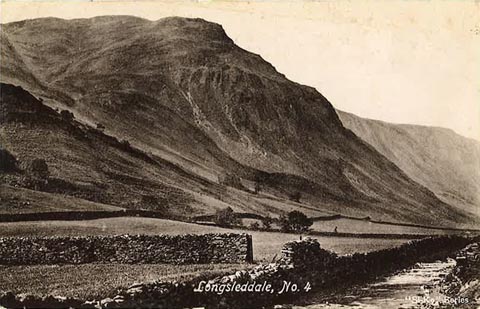 click to enlarge click to enlargePH0042.jpg "Longsleddale, No. 4" "Si-Ko Series" courtesy of Michael Wooldridge item:- private collection : 144 Image © see bottom of page |
|||||||||||||||||||||||||
|
|
||||||||||||||||||||||||||
| evidence:- | textbook:- EPNS Westmorland 1967 |
|||||||||||||||||||||||||
| source data:- | Book, The Place Names of Westmorland, two volumes, by A H Smith,
published for the English Place Name Society by Cambridge
University Press, Cambridgeshire, 1967 |
|||||||||||||||||||||||||
|
|
||||||||||||||||||||||||||
| evidence:- | map:- OS Six Inch (1956) placename:- Goat Scar |
|||||||||||||||||||||||||
| source data:- | Map series, various editions with the national grid, scale about
6 inches to 1 mile, published by the Ordnance Survey,
Southampton, Hampshire, scale 1 to 10560 from 1950s to 1960s,
then 1 to 10000 from 1960s to 2000s, superseded by print on
demand from digital data.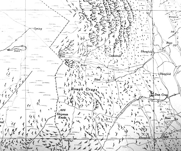 SINY4706.jpg "Goat Scar" |
|||||||||||||||||||||||||
|
|
||||||||||||||||||||||||||
| evidence:- | old print:- Prior 1865 |
|||||||||||||||||||||||||
| source data:- | Print, uncoloured engraving, Gatescarth Pass and Longsleddale, Westmorland, published
by John Garnett, Windermere, Westmorland, and by Simpkin, Marshall and Co, London,
1865.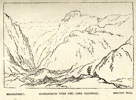 click to enlarge click to enlargePI0107.jpg Included on page 51 of the guide book, Ascents and Passes in the Lake District of England, by Herman Prior. printed at bottom:- "BRANSTREET. / GATESCARTH PASS AND LONG SLEDDALE. / HARTER FELL." item:- JandMN : 235.9 Image © see bottom of page |
|||||||||||||||||||||||||
|
|
||||||||||||||||||||||||||
| evidence:- | old newspaper:- Z8900705.txt placename:- Goat Scar |
|||||||||||||||||||||||||
| source data:- | Z8900705.txt Westmorland Gazette Transcription from the Westmorland Gazette 5 July 1890 page 6:- "... Above Sadgill, we have a narrow channel or pass, bounded on one side by Goat Scar and on the other by Gard Ends. Thus Sleddale becomes the dale of the pass between the scars; ..." |
|||||||||||||||||||||||||
|
|
||||||||||||||||||||||||||
 BIH07.jpg Shadow of Goat Scar in Longsleddale. (taken 29.12.2003) |
||||||||||||||||||||||||||
|
|
||||||||||||||||||||||||||
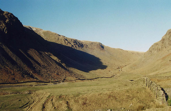
 BJD16.jpg From the track from Sadgill to Gatescarth above Buckbarrow. (taken 7.9.2004)  BJH29.jpg One of series taken for a cardboard cutout Christmas card. (taken 21.12.2004) |
||||||||||||||||||||||||||
|
|
||||||||||||||||||||||||||
Lakes Guides menu.