 Old Cumbria Gazetteer
 |
 |
|
| Gatekirk Cave, North Yorkshire | ||
| Gatekirk Cave | ||
| site name:- | Whernside (roughly) | |
| locality:- | Winterscales | |
| county:- | North Yorkshire | |
| locality type:- | cave | |
| coordinates:- | SD745788 | |
| 1Km square:- | SD7478 | |
| 10Km square:- | SD77 | |
| altitude:- | 950 feet | |
| altitude:- | 290m | |
| SummaryText:- | Grade II; danger of flooding; permission from Broadrake Farm. | |
| references:- | Brook, D & Davies, G & Long, M H &Sutcliffe, J R: 1975: Northern Caves, vol.4 Whernside
and Gragareth: Dalesman Books:: ISBN 0 85206 259 1 |
|
|
|
||
| evidence:- | descriptive text:- West 1778 (11th edn 1821) |
|
| source data:- | Guide book, A Guide to the Lakes, by Thomas West, published by
William Pennington, Kendal, Cumbria once Westmorland, and in
London, 1778 to 1821. goto source goto sourceTour to the Caves in the West Riding of Yorkshire, late 18th century Page 260:- "the bottom [of Weathercoat cave] ... we were also shown above a shallow passage between the strata of rocks, along which we might crawl to the orifice out of which the cascade issued, where it was high enough to walk erect, ... but as we were apprehensive the dangers and difficulties to be encountered in our progress, would not be compensated by the pleasure, we did not attempt to explore these new regions [1]. ..." "[1] ... The owner of the cave, and others, have been in the passage beneath, half way to Ginglepot: they have no doubt but it leads thither: they did not get so far, owing to the water deepening, more than the height lessening. Another subterranean river, that from Gatekirk above, meets this cascade directly underneath it, along which there is a passage, and which the above party, in some measure through mistake, explored, having missed their way in their return, and gone far beyond the cascade, before they were convinced of their error by the noise of the cascade gradually decreasing." goto sourcePage 267:- "... we arrived at ... Gatekirk-Cave. The brook that runs through it forms a fine natural bason of transparent water at its egress, where we entered the cave, gradually increasing in depth till about five or six feet at the most. I believe every one present thought it resembled the cave described by Ovid in the second of his Metamorphoses, where Actaeon unfortunately met with Diana and her nymphs amusing themselves with bathing, when separated from his companions during the chase.-" "Vallis erat piceis et acula densa cupressu, / Nomine Gargaphie; succinctoe cura Dianoe; / Cujus in extremo est antrum nemorlae recessu, / Arte laboratum nulla: simulaverat artem / Ingenio natura suo: nam pumice vivo, / Et levibus tophis nativum duxerat arcum. / Fons sonat a dextra, tenui pellucidus unda, / Margine gramineo patulos succinctus hiatus. / Hic Dea silvarum venatu fessa solebut / Virgineos artus liquido perfundere rore." "Ovid, b.3. fab.2." goto sourcePage 268:- "Down in a vale, with pine and cypress clad, / Refresh'd with gentle winds, and brown with shade, / The chaste Diana's private haunt there stood, / Full in the center of a darksome wood, / A spacious grotto, all around o'ergrown / With hoary moss, and arch'd with pumice-stone: / From out its rocky clefts the waters flow, / And trickling swell into a lake below. / Nature had every where so play'd her part, / That every where she seem'd to vie with art, / Here the bright goddess, toil'd and chaf'd with heat, / Was wont to bathe her in the cool retreat." "Addison." "Over the cave where the water flows, is another subterranean passage, of about twenty-four feet in length, and from three to ten in height. It enters the other obliquely, and looks like a natural orchestra, and where indeed a band of music would exhibit to great advantage to an audience below. The roof of the cave, at the entrance by the stream, is about two yards high, but soon encreases to six. When we had proceeded out of sight of day, a new train of ideas were excited in our imaginations. We could not but fancy that it was like the cave of Polypheme, or of some giant in modern romance, who hung up the mangled limbs of the unhappy victims that fell into his hands, to the dome of his murky den. From the roof were pendant large petrifactions, in every grotesque shape; some like hams, others like neats' tongues, many like the heads and various parts of different animals.- Some parts of this cave appeared like dreary vaults, or catacombs, where were deposited the reliques of ancient heroes or martyrs: some rocks at the bottom appeared like huge stone coffins, and some large petrifactions on the shelves like virgins or children represented in alabaster.- As we proceeded along, we met with several bye-streets or lanes, down some of which came tinkling little currents; but they seemed not to admit a passenger with ease to any great distance. As we went along, we observed that the way divided, for a considerable part of the whole length, into two main streets, which united again," goto sourcePage 269:- "made by the current dividing above into two streams. After we had gone near an hundred yards, we met with an orifice which easily admitted us above ground: we had no curiosity to explore any farther, as the roof was now become only some four feet high, and not admitting us with ease beyond this aperture. The brook which runs through this cave is the main stream of the river Greta, which runs under ground for at last two miles, making its appearance here, at Weathercoat, and a few other places in its way down to its open channel. ..." |
|
|
|
||
| evidence:- | old text:- WTL2p06.txt placename:- Gatekirk Cave |
|
| source data:- | WTL2p06.txt page 6:- "..." "GATEKIRK CAVE." "THIS Cave is situated about a mile above Weathercote, in the same valley. The principal branch of the Greta runs through both, though the river seldom appears in the valley between them, as it there runs underground nearly the whole of the way. There are two entrances; one towards the north, and the other to the south. The Cave is probably three hundred feet long, the interior consisting generally of a narrow passage between perpendicular rocks, with the river running through, and of several smaller passages, which convey water to the main stream. Stalactites abound here, of a much finer quality than those at Yordas Cave, hanging like large icicles from the roof; some that are just forming will crumble between the fingers; others are hard, though somewhat porous," WTL2p07.txt page 7:- "with the inside composed of small crystals: the larger ones are as hard as marble, and will take as fine a polish. The cave cannot be entered at either of the openings represented in this plate, the water being too deep; but there is an interesting view looking into the cave from the path above." |
|
|
|
||
| evidence:- | old print:- Westall 1818 placename:- Gatekirk Cave |
|
| source data:- | Print, uncoloured aquatint, Gatekirk Cave, Yorkshire, drawn and engraved by William
Westall, published by John Murray, Albemarle Street, London, 1818.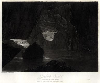 click to enlarge click to enlargeWTL209.jpg "Drawn & Etch'd by Willm. Westall A.R.A. / Gatekirk Cave, / looking from the North entrance. / Publish'd July 12. 1818. by John Murray, Albemarle Street, London. / Proof" item:- Armitt Library : A6670.9 Image © see bottom of page |
|
|
|
||
| evidence:- | descriptive text:- Otley 1823 (8th edn 1849) placename:- Gatekirk Cave |
|
| source data:- | Guide book, A Concise Description of the English Lakes, the
mountains in their vicinity, and the roads by which they may be
visited, with remarks on the mineralogy and geology of the
district, by Jonathan Otley, published by the author, Keswick,
Cumberland now Cumbria, by J Richardson, London, and by Arthur
Foster, Kirkby Lonsdale, Cumbria, 1823; published 1823-49,
latterly as the Descriptive Guide to the English Lakes. goto source Page 199:- "..." "GATEKIRK CAVE.- This beautiful cavern is about a mile and a half north of Weathercote. It has two en-" goto sourcePage 201:- "[en]trances, one north and another south. There is another passage from the south-west, which has been likened to an orchestra. The main branch of the Greet runs through this cave. The stalactites and stalagmites are in the greatest profusion and perfection. The whole surface of the roof is hung with grotesque shapes in stone; and the ledge on the western side is like an image-maker's shop, so full is it of stalagmites of every variety of form. There are several alleys branching off the main passage. The water issues from the cavern in a deep, clear, and strong stream, and is broken into a succession of cascades and eddies, shaded by weeping willows and mountain ash, until it loses itself amongst the group of rocks." |
|
|
|
||
| evidence:- | descriptive text:- Balderston c1890 placename:- item:- stalactite item:- stalactite |
|
| source data:- | Book, Ingleton, Bygone and Present, by Robert R and Margaret
Balderston, published by Simpkin, Marshall and Co, London, and
by Edmndson and Co, 24 High Street, Skipton, Yorkshire, about
1890. goto source page 37:- "..." "Gatekirk Cave." "Some distance above Weathercote is Gatekirk Cave, the subterranean passage of the Doe in its upper section; its ramifications are many. The main point of exit is to the south, that of entry to the north. At one time the stalactites and stalagmites existed in great profusion, and the whole surface of the rock is described as having been covered with grotesque shapes in stone, whilst the ledge on the side next Whernside was likened to an" goto sourcepage 38:- "image-maker's shop, so full was it of stalagmites of an infinite variety of forms. As in Douk Cave, there are alleys divaricating from the main cavern and leading to caves described under other names, whilst the Doe, although here so far up the mountains, quits its subterranean tenement as a by no means insignificant stream, and has its course broken by a series of foaming but puny falls, darkened by overhanging underwood, until it is once more embowelled in other inaccessible passages a little further down the dale. There are several openings in this cave at various points, the first being about sixty-three yards above the mouth, and in this portion the rush of water is very strong even at low water, but the passage is very spacious should the cave-hunter not object to wet feet. The first thing of note that greets the eye on entering is a wide pool of water, round the eastern side of which it is possible to pass, then tremendous masses of rock, thrown at random in the way, have to be surmounted, and in higher sections, or in the ultimate branches, cascades of various sizes are found; for this reason we urgently advise cave-hunters to make their explorations in an upward direction wherever there is no guide, and where there is both an upper as well as a lower mouth, for only recently, whilst descending a cave not described, we suddenly found our course arrested by a rift thirty feet deep. Be plentifully supplied with candles, and do not proceed too rapidly, for in another cave we come to the head of a waterfall of just the same depth. Turning to the left, directly towards the spur of Whernside, a few minutes' walk is all that is required to reach Bruntscar; but before doing this it is as well to notice Haws Gill Wheel, a little below Gatekirk, where several streams issue from the ground, one of which appears to come from the place next described." goto sourcepage 39:- "..." "About three-quarters of a mile north-east of Bruntscar, behind the edge of a low line of rocks called Scar Top, is a kind of shakehole with small trees about it. On descending the hollow two caves are found, one of debouchure, the other of engulfment, the latter being fully worthy of exploration, and in fact an upper branch of Gatekirk Cave. ..." |
|
|
|
||
| evidence:- | old map:- Balderston c1890 map placename:- Gate Kirk Cave |
|
| source data:- | Map, the hills in the Ingleton area, probably by Robert R
Balderston, engraved by Goodall and Suddick, Leeds, West
Yorkshire, about 1890.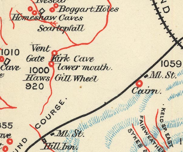 BS1SD77P.jpg "Gate Kirk Cave" item:- private collection : 27.1 Image © see bottom of page |
|
|
|
||
Lakes Guides menu.