 Old Cumbria Gazetteer
 |
 |
|
| Esk Hause, Eskdale | ||
| Esk Hause | ||
| civil parish:- | Eskdale (formerly Cumberland) | |
| civil parish:- | Borrowdale (formerly Cumberland) | |
| county:- | Cumbria | |
| locality type:- | pass | |
| coordinates:- | NY23260811 | |
| 1Km square:- | NY2308 | |
| 10Km square:- | NY20 | |
|
|
||
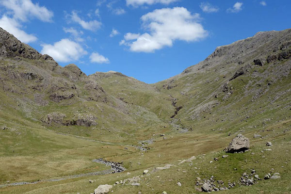 BYN43.jpg (taken 4.6.2013) |
||
|
|
||
| evidence:- | old map:- OS County Series (Cmd 75 9) placename:- Esk Hause |
|
| source data:- | Maps, County Series maps of Great Britain, scales 6 and 25
inches to 1 mile, published by the Ordnance Survey, Southampton,
Hampshire, from about 1863 to 1948. |
|
|
|
||
| evidence:- | outline view:- Otley 1823 (4th edn 1830) placename:- Esk Hause |
|
| source data:- | Print, engraving, outline view, Mountains South West of Derwentwater as seen from
Keswick, published by Jonathan Otley, Keswick, Cumberland et al, 1830.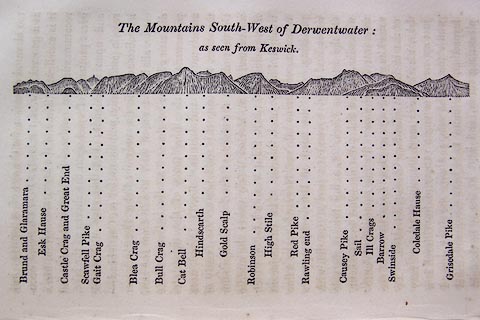 click to enlarge click to enlargeO75E06.jpg p.115 in A Concise Description of the English Lakes, by Jonathan Otley, 4th edition, 1830. "The Mountains South-West of Derwentwater: / as seen from Keswick." "Brund and Glaramara / Esk Hause / Castle Crag and Great End / Scawfell Pike / Gait Crag / Blea Crag / Bull Crag / Cat Bell / Hindscarth / Gold Scalp / Robinson / High Stile / Red Pike / Rawling end / Causey Pike / Sail / Ill Crags / Barrow / Swinside / Coledale Hause / Grisedale Pike" item:- Armitt Library : A1175.6 Image © see bottom of page |
|
|
|
||
| evidence:- | outline view:- Otley 1823 (5th edn 1834) |
|
| source data:- | Print, woodcut outline view, The Mountains South West of
Derwentwater, by Jonathan Otley, Keswick, Cumberland, 1830.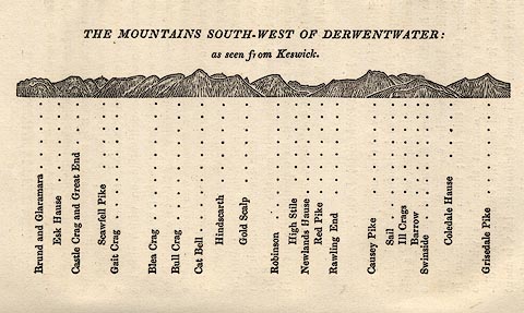 click to enlarge click to enlargeOT2E04.jpg Printed on p.21 of A Concise Description of the English Lakes, by Jonathan Otley, 5th edition, 1834. "THE MOUNTAINS SOUTH-WEST OF DERWENTWATER: as seen from Keswick" "Brund and Glaramara / Esk Hause / Castle Crag and Great End / Scawfell Pike / Gait Crag / Blea Crag / Bull Crag / Cat Bell / Hindscarth / Gold Scalp / Robinson / High Stile / Newlands Hause / Red Pike / Rawling End / Causey Pike / Sail / Ill Crags / Barrow / Swinside / Coledale Hause / Grisedale Pike" item:- JandMN : 48.5 Image © see bottom of page |
|
|
|
||
| evidence:- | descriptive text:- Otley 1823 (5th edn 1834) placename:- Ash Course |
|
| source data:- | Guide book, A Concise Description of the English Lakes, the
mountains in their vicinity, and the roads by which they may be
visited, with remarks on the mineralogy and geology of the
district, by Jonathan Otley, published by the author, Keswick,
Cumberland now Cumbria, by J Richardson, London, and by Arthur
Foster, Kirkby Lonsdale, Cumbria, 1823; published 1823-49,
latterly as the Descriptive Guide to the English Lakes. goto source goto sourcePage 66:- "... leave the Wasdale road at the bridge, proceeding by the side of the gill towards Esk Hause, (which some of our learned topographers have converted into Ash-course,) ..." |
|
|
|
||
| evidence:- | old text:- Martineau 1855 |
|
| source data:- | Guide book, A Complete Guide to the English Lakes, by Harriet
Martineau, published by John Garnett, Windermere, Westmorland,
and by Whittaker and Co, London, 1855; published 1855-76. goto source Page 150:- "... From Esk Hause, there is a singular view, composed of three lines of landscape. One begins with Borrowdale, lying immediately below, and extends to Derwentwater and Bassenthwaite, past Skiddaw, in full glory, and on over the whole intervening plain, to the Solway and the Scotch mountains. This is the north-western view.- The opposite, or south-eastern one, begins with Langdale, and proceeds by the opening of the Brathay valley and Windermere, till it is closed in by Ingleborough, in Yorkshire.- The third, and intermediate view, is down Eskdale, past its verdure and its cataracts, past the sands, past lonely Blackcombe, to the broad sea. When we were on Esk Hause, the spectacle of these three lines of landscape was remarkable. Towards Keswick, the atmosphere was thick, just to the degree that gave a visionary character to the long perspective. The lake of Derwentwater was hardly distinguishable from its shores, so that the wooded islands and the town of Keswick lay as if in air, still and unsubstantial. In the direction of Eskdale, all was bright and glittering; while from Langdale and the head of Borrowdale the" goto sourcePage 151:- "white mists came tumbling out towards us, as if to stifle us; and nothing could be seen, except at intervals, when a whiff of wind disclosed long sweeps of the sides of the valleys, and stretches of the streams and fields below. It is these changes that give a singular charm to this mountain district. The residents of the valleys, in their occasional ascents to these heights, never see the scene twice alike,- the great landmarks themselves being scarcely recognizable but by certain incidents of their forms." |
|
|
|
||
Lakes Guides menu.