 Old Cumbria Gazetteer
 |
 |
|
||||||||||||||||||||||||
| Dent, Cleator Moor | ||||||||||||||||||||||||||
| Dent | ||||||||||||||||||||||||||
| civil parish:- | Cleator Moor (formerly Cumberland) | |||||||||||||||||||||||||
| county:- | Cumbria | |||||||||||||||||||||||||
| locality type:- | hill | |||||||||||||||||||||||||
| coordinates:- | NY03891321 (? etc) | |||||||||||||||||||||||||
| 1Km square:- | NY0313 | |||||||||||||||||||||||||
| 10Km square:- | NY01 | |||||||||||||||||||||||||
| altitude:- | 1155 feet | |||||||||||||||||||||||||
| altitude:- | 352m | |||||||||||||||||||||||||
|
|
||||||||||||||||||||||||||
| evidence:- | old map:- OS County Series (Cmd 68 13) placename:- Dent |
|||||||||||||||||||||||||
| source data:- | Maps, County Series maps of Great Britain, scales 6 and 25
inches to 1 mile, published by the Ordnance Survey, Southampton,
Hampshire, from about 1863 to 1948. OS County Series (Cmd 67 16) |
|||||||||||||||||||||||||
|
|
||||||||||||||||||||||||||
| evidence:- | old map:- Saxton 1579 placename:- Dent Hill |
|||||||||||||||||||||||||
| source data:- | Map, hand coloured engraving, Westmorlandiae et Cumberlandiae Comitatus ie Westmorland
and Cumberland, scale about 5 miles to 1 inch, by Christopher Saxton, London, engraved
by Augustinus Ryther, 1576, published 1579-1645.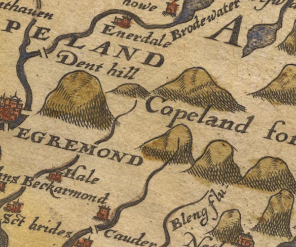 Sax9NY01.jpg "Dent hill" Hillock. item:- private collection : 2 Image © see bottom of page |
|||||||||||||||||||||||||
|
|
||||||||||||||||||||||||||
| evidence:- | old map:- Mercator 1595 (edn?) placename:- Dent hill |
|||||||||||||||||||||||||
| source data:- | Map, hand coloured engraving, Northumbria, Cumberlandia, et
Dunelmensis Episcopatus, ie Northumberland, Cumberland and
Durham etc, scale about 6.5 miles to 1 inch, by Gerard Mercator,
Duisberg, Germany, about 1595. MER8CumE.jpg "Dent hill" hillock, shaded on east; hill or mountain item:- JandMN : 169 Image © see bottom of page |
|||||||||||||||||||||||||
|
|
||||||||||||||||||||||||||
| evidence:- | old map:- Speed 1611 (Cmd) placename:- Dent Hill |
|||||||||||||||||||||||||
| source data:- | Map, hand coloured engraving, Cumberland and the Ancient Citie
Carlile Described, scale about 4 miles to 1 inch, by John Speed,
1610, published by J Sudbury and George Humble, Popes Head
Alley, London, 1611-12.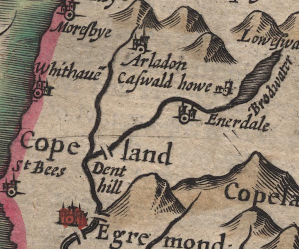 SP11NY01.jpg "Dent hill" hillock item:- private collection : 16 Image © see bottom of page |
|||||||||||||||||||||||||
|
|
||||||||||||||||||||||||||
| evidence:- | old map:- Drayton 1612/1622 placename:- Dent Hill |
|||||||||||||||||||||||||
| source data:- | Map, hand coloured engraving, Cumberlande and Westmorlande, by
Michael Drayton, probably engraved by William Hole, scale about
4 or 5 miles to 1 inch, published by John Mariott, John
Grismand, and Thomas Dewe, London, 1622.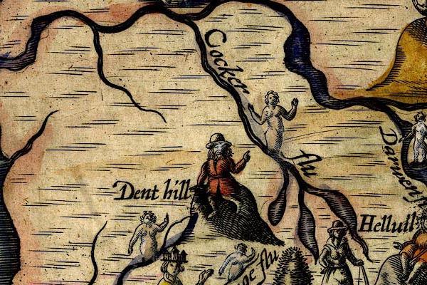 DRY513.jpg "Dent hill" Hillock with a gentleman on top. item:- JandMN : 168 Image © see bottom of page |
|||||||||||||||||||||||||
|
|
||||||||||||||||||||||||||
| evidence:- | old map:- Jansson 1646 placename:- Dent Hill |
|||||||||||||||||||||||||
| source data:- | Map, hand coloured engraving, Cumbria and Westmoria, ie
Cumberland and Westmorland, scale about 3.5 miles to 1 inch, by
John Jansson, Amsterdam, Netherlands, 1646.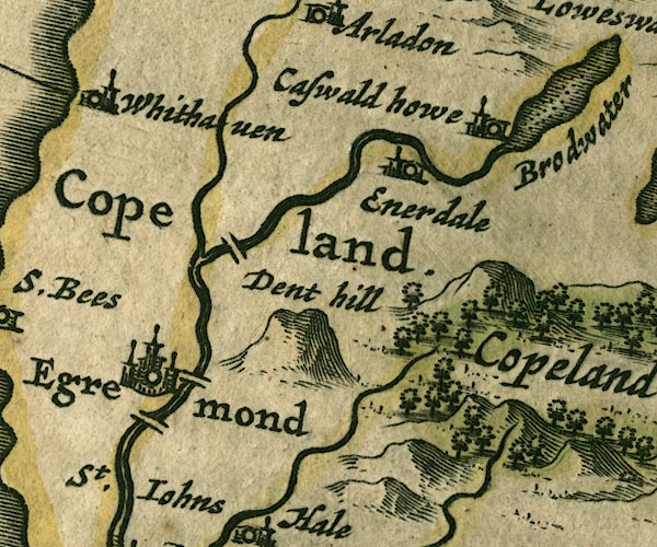 JAN3NY01.jpg "Dent hill" Lumpy hillock. item:- JandMN : 88 Image © see bottom of page |
|||||||||||||||||||||||||
|
|
||||||||||||||||||||||||||
| evidence:- | old map:- Morden 1695 (Cmd) placename:- Dent Hill |
|||||||||||||||||||||||||
| source data:- | Map, uncoloured engraving, Cumberland, scale about 4 miles to 1
inch, by Robert Morden, 1695, published by Abel Swale, the
Unicorn, St Paul's Churchyard, Awnsham, and John Churchill, the
Black Swan, Paternoster Row, London, 1695-1715.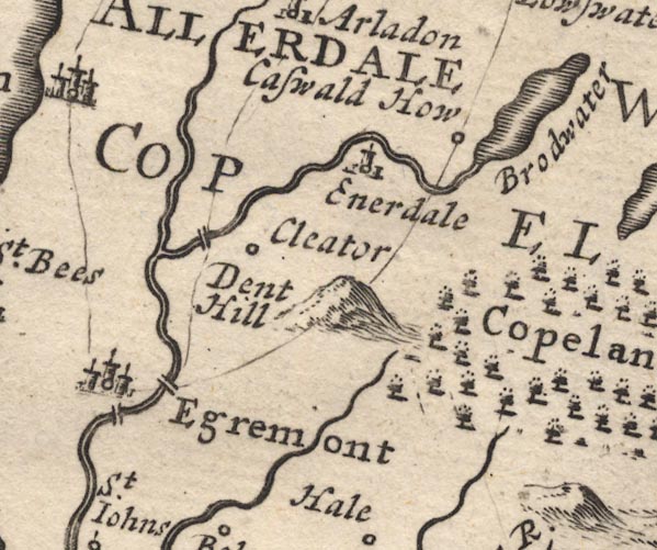 MD12NY01.jpg "Dent Hill" Hillock. item:- JandMN : 90 Image © see bottom of page |
|||||||||||||||||||||||||
|
|
||||||||||||||||||||||||||
| evidence:- | old map:- Bowen and Kitchin 1760 placename:- Dent Hill |
|||||||||||||||||||||||||
| source data:- | Map, hand coloured engraving, A New Map of the Counties of
Cumberland and Westmoreland Divided into their Respective Wards,
scale about 4 miles to 1 inch, by Emanuel Bowen and Thomas
Kitchin et al, published by T Bowles, Robert Sayer, and John
Bowles, London, 1760.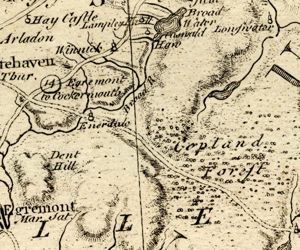 BO18NY01.jpg "Dent Hill" hill hachuring item:- Armitt Library : 2008.14.10 Image © see bottom of page |
|||||||||||||||||||||||||
|
|
||||||||||||||||||||||||||
| evidence:- | old map:- Donald 1774 (Cmd) placename:- Dent |
|||||||||||||||||||||||||
| source data:- | Map, hand coloured engraving, 3x2 sheets, The County of Cumberland, scale about 1
inch to 1 mile, by Thomas Donald, engraved and published by Joseph Hodskinson, 29
Arundel Street, Strand, London, 1774.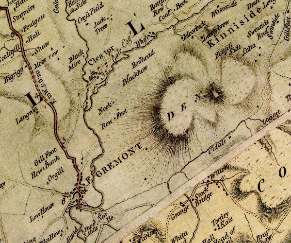 D4NY01SW.jpg "DENT" hill hachuring; a hill or mountain item:- Carlisle Library : Map 2 Image © Carlisle Library |
|||||||||||||||||||||||||
|
|
||||||||||||||||||||||||||
| evidence:- | old map:- Otley 1818 placename:- Dent |
|||||||||||||||||||||||||
| source data:- | Map, uncoloured engraving, The District of the Lakes,
Cumberland, Westmorland, and Lancashire, scale about 4 miles to
1 inch, by Jonathan Otley, 1818, engraved by J and G Menzies,
Edinburgh, Scotland, published by Jonathan Otley, Keswick,
Cumberland, et al, 1833.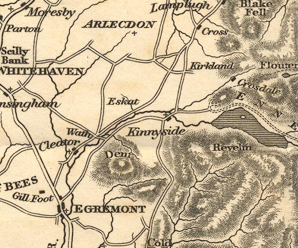 OT02NY01.jpg item:- JandMN : 48.1 Image © see bottom of page |
|||||||||||||||||||||||||
|
|
||||||||||||||||||||||||||
| evidence:- | descriptive text:- Ford 1839 (3rd edn 1843) placename:- Dent item:- altitude, Dent |
|||||||||||||||||||||||||
| source data:- | Guide book, A Description of Scenery in the Lake District, by
Rev William Ford, published by Charles Thurnam, Carlisle, by W
Edwards, 12 Ave Maria Lane, Charles Tilt, Fleet Street, William
Smith, 113 Fleet Street, London, by Currie and Bowman,
Newcastle, by Bancks and Co, Manchester, by Oliver and Boyd,
Edinburgh, and by Sinclair, Dumfries, 1839. goto source goto sourcePage 178:- "ELEVATION OF THE MOUNTAINS," "ACCORDING TO DIFFERENT AUTHORITIES."
|
|||||||||||||||||||||||||
|
|
||||||||||||||||||||||||||
| evidence:- | old map:- Ford 1839 map placename:- Dent |
|||||||||||||||||||||||||
| source data:- | Map, uncoloured engraving, Map of the Lake District of
Cumberland, Westmoreland and Lancashire, scale about 3.5 miles
to 1 inch, published by Charles Thurnam, Carlisle, and by R
Groombridge, 5 Paternoster Row, London, 3rd edn 1843.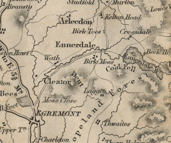 FD02NY01.jpg "Dent" Hill hachuring. item:- JandMN : 100.1 Image © see bottom of page |
|||||||||||||||||||||||||
|
|
||||||||||||||||||||||||||
| evidence:- | old map:- Garnett 1850s-60s H placename:- Dent Hill |
|||||||||||||||||||||||||
| source data:- | Map of the English Lakes, in Cumberland, Westmorland and
Lancashire, scale about 3.5 miles to 1 inch, published by John
Garnett, Windermere, Westmorland, 1850s-60s.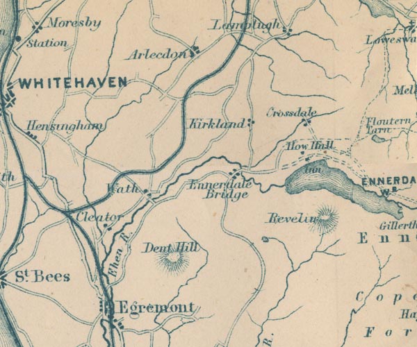 GAR2NY01.jpg "Dent Hill" hill hachuring item:- JandMN : 82.1 Image © see bottom of page |
|||||||||||||||||||||||||
|
|
||||||||||||||||||||||||||
| evidence:- | old map:- Postlethwaite 1877 (3rd edn 1913) placename:- Dent Hill |
|||||||||||||||||||||||||
| source data:- | Map, uncoloured engraving, Map of the Lake District Mining Field, Westmorland, Cumberland,
Lancashire, scale about 5 miles to 1 inch, by John Postlethwaite, published by W H
Moss and Sons, 13 Lowther Street, Whitehaven, Cumberland, 1877 edn 1913.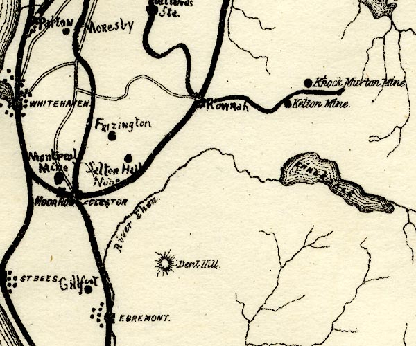 PST2NY01.jpg "Dent Hill" hill hachuring item:- JandMN : 162.2 Image © see bottom of page |
|||||||||||||||||||||||||
|
|
||||||||||||||||||||||||||
Lakes Guides menu.