 Old Cumbria Gazetteer
 |
 |
|
| Dalton Hall, Burton-in-Kendal | ||
| Dalton Hall | ||
| Street:- | Dalton Lane | |
| locality:- | Dalton Park | |
| locality:- | Dalton | |
| civil parish:- | Burton-in-Kendal (formerly Westmorland) | |
| county:- | Cumbria | |
| locality type:- | buildings | |
| coordinates:- | SD53697577 | |
| 1Km square:- | SD5375 | |
| 10Km square:- | SD57 | |
|
|
||
| evidence:- | old text:- Gents Mag item:- Quamps, The |
|
| source data:- | Magazine, The Gentleman's Magazine or Monthly Intelligencer or
Historical Chronicle, published by Edward Cave under the
pseudonym Sylvanus Urban, and by other publishers, London,
monthly from 1731 to 1922. goto source goto sourceGentleman's Magazine 1776 p.310 "Mr. URBAN," "IF you think the following piece of antiquity worthy of a place in your Magazine, you will oblige the writer by inserting it. Conjectures of its age and use have been formed, but the decision is left to antiquarians by profession; some of whom, it is hoped, will favour the public with their sentiments concerning an article in their way, which is, perhaps not frequently to be met with." "Lancaster, July, 6." "W.C." "Account of some remarkable Foundations of Walls, discovered on clearing a Field called The Quamps, in Dalton Hall, Demesne, (near Burton in Kendal,) in the latter End of the Year 1774. See the following Figure." "THE fence of the field, a, a, a, a, sketched out by the eye, is a hedge, as are all the fences in that neighbourhood. The black lines, b, b, ,b, are the ground plot of the wall. They were all thrown down, and grown over in many places with bushes; but the foundation stones appeared to be laid by a line, and the two outside faces were about three yards distance. The intermediate spaces were filled up with any kind of cobbles, &c. These foundation stones were large lime-stones, with which that part of the country abounds, and generally as big as two or three men could move; but no mortar was discovered, nor any marks of the hammer, except in some freestone ones at the corners. The dotted lines, c. c, c, (drawn by the eye,) had much the same appearance as the rest; but the marks of a regular wall were not so evident there; and I believe the plan does not notice all the vestiges that were remaining of this kind. The annexed dimensions are not very accurate, as they were taken after the stones were removed. There were openings like common gateways into these enclosures, and some stones were found at the edges of these gateways, near a foot under the soil, with holes in them, such as are now in use for gates to turn upon by means of iron pivots. There are two springs in the field at d and e. The spring d is never dry; that at e, not certain how it is. The area at f is low and soft in the bottom; as if it had been a receptacle for water." "The field containing these walls is pretty level, and on an eminence of the most western of a number which had formerly been covered with an extensive oak wood, and which again were bounded to the eastward with large moors reaching many miles north and south. The field has as spacious a view to the west and south, as most which are found in this hilly country. But its prospect is obstructed by an eminence about a quarter of a mile to the south-west, on the top of which, some say, there were very lately a small mound and trench. Also, at about an equal distance to the north east of these walls, were dug up, at the same time, the foundations of an enclosure of a like kind, near forty yards square, divided into two unequal oblongs, and whose walls were above three yards thick. And in a line with this, the Quamps, and the mound, is an appearance of other walls, though of inferior dimensions, which are yet unmolested. There are remains of two old halls within a mile of these ruins, and one of them has a large enclosure adjoining to it that is moated round. These remains and tradition, however, discover nothing, relating to them that is any way worth notice; neither is there the least tradition concerning the walls in" |
|
|
|
||
| evidence:- | old text:- Gents Mag 1774 |
|
| source data:- | goto source Gentleman's Magazine 1776 p.311 "question, which before their clearing away could appear only like common stone-heaps. In digging up these ruins an old copper pan was found, some small stone mortars, and the fragments of near twenty pair of hand-mill-stones, such as are intimated by the figure; but nothing else of any utensil kind. The mill-stones were of very coarse freestone, and from a quarry about three miles distant; near twelve inches in diameter, and picked and hollowed in the ordinary manner. In the bottom stone B was a hole, as at n, where it is supposed an iron spike was fastened for the top-stone A to turn upon, by means of an orifice at r. Down the conical pipe m r the grain was supposed to fall between the stones, as from a common hopper. Some had a hole in the side of the top stone as at o; others were without, and others again were seemingly unfinished. On ploughing the field, nothing more was discovered deserving particular notince, except some ashes with the areas, and some burnt cobble-stones. - No remains of any thing like fire-places were found in these walls; and, indeed, their situation was rather too bleak for dwelling-houses." 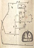 click to enlarge click to enlargeG776E01.jpg |
|
|
|
||
| evidence:- | old text:- Camden 1789 (Gough Additions) placename:- Dalton Hall |
|
| source data:- | Book, Britannia, or A Chorographical Description of the Flourishing Kingdoms of England,
Scotland, and Ireland, by William Camden, 1586, translated from the 1607 Latin edition
by Richard Gough, published London, 1789. goto source Page 153:- "..." "In cleaning a field called The Quamps in Dalton hall demesne near Burton in Kendal 1774, were discovered foundations of large stones with door-ways in them, a copper pan, some small stone mortars, and a great number of stone hand mills. Within a mile of these ruins are two old halls. A quarter of a mile south-west of this spot was lately a small mound and trench; and at about an equal distance to the north were dug up at the same time foundations of a like inclosure near 40 yards square." |
|
|
|
||
| evidence:- | old map:- Garnett 1850s-60s H placename:- Dalton Hall |
|
| source data:- | Map of the English Lakes, in Cumberland, Westmorland and
Lancashire, scale about 3.5 miles to 1 inch, published by John
Garnett, Windermere, Westmorland, 1850s-60s.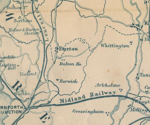 GAR2SD57.jpg "Dalton Ha." block, building item:- JandMN : 82.1 Image © see bottom of page |
|
|
|
||
| Paley and Austin series | ||
| person:- | architect : Paley, Edward G |
|
| date:- | 1859 |
|
| Added parts in a classical style; later demolished. |
||
|
|
||
Lakes Guides menu.