 Old Cumbria Gazetteer
 |
 |
|
| Clark's Leap, St John's Castlerigg etc | ||
| Clark's Leap | ||
| site name:- | Thirlmere | |
| civil parish:- | St John's Castlerigg and Wythburn (formerly Cumberland) | |
| county:- | Cumbria | |
| locality type:- | rocks (?) | |
| locality type:- | locality | |
| coordinates:- | NY31991549 (?) | |
| 1Km square:- | NY3115 | |
| 10Km square:- | NY31 | |
|
|
||
| evidence:- | old map:- OS County Series (Cmd 70 12) placename:- Clark's Leap |
|
| source data:- | Maps, County Series maps of Great Britain, scales 6 and 25
inches to 1 mile, published by the Ordnance Survey, Southampton,
Hampshire, from about 1863 to 1948. |
|
|
|
||
| evidence:- | old text:- Clarke 1787 placename:- Clark's Leap item:- suicide; drowning |
|
| source data:- | Guide book, A Survey of the Lakes of Cumberland, Westmorland,
and Lancashire, written and published by James Clarke, Penrith,
Cumberland, and in London etc, 1787; published 1787-93. goto source goto sourcePage 117:- "..." "Passing Swirl's-Gate, a little beyond the seven mile-post, is seen a rock jutting out into the Lake which has got the name of Clark's-Leap, from the following strange story: A man of the name of Clark was jealous of his wife to that degree he was resolved to put an end to his own existence. He communicated his resolution to his wife, and told her at the same time, that he was determined to hang himself: to this she objected, for fear it might prove too painful: he then said he would shoot himself; but from this she likewise dissuaded him, for fear he might not kill himself outright, and so suffer extreme pain to no purpose: he next proposed to drown himself; this pleased her, and they went lovingly together to the water's edge: he then proposed to wade in," goto sourcePage 118:- "but the said weather was so cold, that he would suffer much needless pain: they then walked by the water-side till they came to this rock, which she told him she thought it fit for his purpose, as the water was deep enough at the edge to drown him: He was the going to throw himself directly in, but she told him he might hurt himself against the rock before he reached the water, so that he had better take a run and leap as far as he could: He followed her advice, very calmly put off his coat and took his leap: she staid till she saw him drowned, and then returned, fully satisfied that she had done her duty in giving him the best advice she could. This story she related to her neighbours, and I had the curiosity (for she is still alive,) to ask it from her own mouth." |
|
|
|
||
| evidence:- | old map:- Clarke 1787 map (Ambleside to Keswick) placename:- Clark's Leap |
|
| source data:- | Map, A Map of the Roads Lakes etc between Keswick and Ambleside,
scale about 2.5 ins to 1 mile, by James Clarke, engraved by S J
Neele, 352 Strand, published by James Clarke, Penrith,
Cumberland and in London etc, 1787.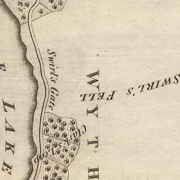 CL9NY31H.jpg "Clark's Leap" item:- private collection : 10.9 Image © see bottom of page |
|
|
|
||
| evidence:- | old text:- Collingwood 1902 placename:- Clark's Lowp |
|
| source data:- | Book, The Lake Counties, by W G Collingwood, published by J M
Dent and Sons, London, 1902 etc. "Opposite Deergarth is Clark's Loup, where a henpecked dalesman drowned himself. The story goes that his widow only remarked 'he had often threatened it, but she never thought the fool had the courage.'" |
|
|
|
||
| evidence:- | map:- Parker 2002 placename:- Clark's Loup |
|
| source data:- | Atlas, An Atlas of the English Lakes, by John Wilson Parker,
published by Cicerone Press, Milnthorpe, Cumbria, 2002 |
|
|
|
||
Lakes Guides menu.