 |
 |
   |
|
|
|
Castlesteads |
| locality:- |
Yanwath Wood |
| civil parish:- |
Yanwath and Eamont Bridge (formerly Westmorland) |
| county:- |
Cumbria |
| locality type:- |
british settlement |
| locality type:- |
settlement |
| locality type:- |
earthwork |
| coordinates:- |
NY51852520 |
| 1Km square:- |
NY5125 |
| 10Km square:- |
NY52 |
|
|
| evidence:- |
old text:- Camden 1789 (Gough Additions)
placename:- Castle Steads
|
| source data:- |
Book, Britannia, or A Chorographical Description of the Flourishing Kingdoms of England,
Scotland, and Ireland, by William Camden, 1586, translated from the 1607 Latin edition
by Richard Gough, published London, 1789.
 goto source goto source
Page 162:- "..."
"About a mile from Yanwath hall at the end of the wood opposite Lowther hall is an
antient round fortification called Castle steads."
|
|
|
| evidence:- |
site plan:- Historical Monuments 1936
placename:- Castlesteads
|
| source data:- |
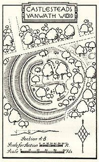
Site plan, uncoloured lithograph, Castlesteads Yanwath Wood, Yanwath and Eamont Bridge,
Westmorland, scale about 1 to 1300, published by Royal Commission on Historical Monuments
England, London, 1936.
 click to enlarge click to enlarge
HMW149.jpg
On p.254 of the Inventory of the Historical Monuments in Westmorland.
printed, top "CASTLESTEADS / YANWATH WOOD"
RCHME no. Wmd, Yanwath and Eamont Bridge 15
item:- Armitt Library : A745.150
Image © see bottom of page
|
|
|


 goto source
 click to enlarge