 Old Cumbria Gazetteer
 |
 |
|
| Capplethwaite Hall, Killington | ||
| Capplethwaite Hall | ||
| civil parish:- | Killington (formerly Westmorland) | |
| county:- | Cumbria | |
| locality type:- | buildings | |
| coordinates:- | SD62249181 | |
| 1Km square:- | SD6291 | |
| 10Km square:- | SD69 | |
|
|
||
| evidence:- | old map:- OS County Series (Wmd 39 8) placename:- Capplethwaite Hall |
|
| source data:- | Maps, County Series maps of Great Britain, scales 6 and 25
inches to 1 mile, published by the Ordnance Survey, Southampton,
Hampshire, from about 1863 to 1948. |
|
|
|
||
| evidence:- | old map:- Jefferys 1770 (Wmd) placename:- Capplethwaite |
|
| source data:- | Map, 4 sheets, The County of Westmoreland, scale 1 inch to 1
mile, surveyed 1768, and engraved and published by Thomas
Jefferys, London, 1770.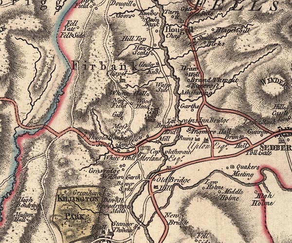 J5SD69SW.jpg "Capplethwaite / Morland Esqr." grand house and garden or terrace item:- National Library of Scotland : EME.s.47 Image © National Library of Scotland |
|
|
|
||
| evidence:- | old map:- Cary 1789 (edn 1805) placename:- Copplethwaite |
|
| source data:- | Map, uncoloured engraving, Westmoreland, scale about 2.5 miles
to 1 inch, by John Cary, London, 1789; edition 1805. CY24SD69.jpg "Copplethwaite" house symbol; large house item:- JandMN : 129 Image © see bottom of page |
|
|
|
||
| evidence:- | road book:- Cary 1798 (2nd edn 1802) placename:- Capplethwaite Hall |
|
| source data:- | Road book, itineraries, Cary's New Itinerary, by John Cary, 181
Strand, London, 2nd edn 1802. goto source goto source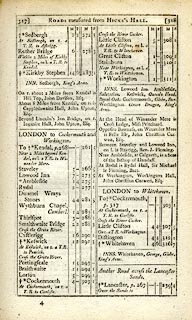 click to enlarge click to enlargeC38317.jpg page 317-318 "About 8 Miles from Kendal, on r. is Capplethwaite Hall, John Upton, Esq." item:- JandMN : 228.1 Image © see bottom of page |
|
|
|
||
| evidence:- | old map:- Ford 1839 map placename:- Cappelthwaite |
|
| source data:- | Map, uncoloured engraving, Map of the Lake District of
Cumberland, Westmoreland and Lancashire, scale about 3.5 miles
to 1 inch, published by Charles Thurnam, Carlisle, and by R
Groombridge, 5 Paternoster Row, London, 3rd edn 1843. FD02SD69.jpg "Cappelthwaite" item:- JandMN : 100.1 Image © see bottom of page |
|
|
|
||
Lakes Guides menu.