 Old Cumbria Gazetteer
 |
 |
|
||||||||||||||||||||||||
| Calf, Sedbergh | ||||||||||||||||||||||||||
| locality:- | Howgill Fells | |||||||||||||||||||||||||
| civil parish:- | Sedbergh (formerly Yorkshire) | |||||||||||||||||||||||||
| civil parish:- | Orton S (formerly Westmorland) | |||||||||||||||||||||||||
| county:- | Cumbria | |||||||||||||||||||||||||
| locality type:- | hill | |||||||||||||||||||||||||
| coordinates:- | SD667970 | |||||||||||||||||||||||||
| 1Km square:- | SD6697 | |||||||||||||||||||||||||
| 10Km square:- | SD69 | |||||||||||||||||||||||||
| altitude:- | 2218 feet | |||||||||||||||||||||||||
| altitude:- | 676m | |||||||||||||||||||||||||
|
|
||||||||||||||||||||||||||
| evidence:- | possibly old map:- Jefferys 1770 (Wmd) placename:- Hood |
|||||||||||||||||||||||||
| source data:- | Map, 4 sheets, The County of Westmoreland, scale 1 inch to 1
mile, surveyed 1768, and engraved and published by Thomas
Jefferys, London, 1770.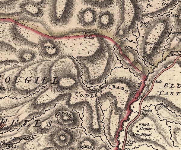 J5SD69NE.jpg "HOOD" hill hachuring; hill or mountain item:- National Library of Scotland : EME.s.47 Image © National Library of Scotland |
|||||||||||||||||||||||||
|
|
||||||||||||||||||||||||||
| evidence:- | possibly old map:- Cary 1789 (edn 1805) placename:- Hood |
|||||||||||||||||||||||||
| source data:- | Map, uncoloured engraving, Westmoreland, scale about 2.5 miles
to 1 inch, by John Cary, London, 1789; edition 1805.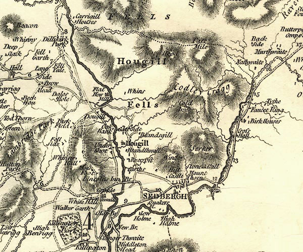 CY24SD69.jpg "H[o]od" hill hachuring item:- JandMN : 129 Image © see bottom of page |
|||||||||||||||||||||||||
|
|
||||||||||||||||||||||||||
| evidence:- | descriptive text:- Otley 1823 (5th edn 1834) item:- latitude; longitude; lat and long |
|||||||||||||||||||||||||
| source data:- | Guide book, A Concise Description of the English Lakes, the
mountains in their vicinity, and the roads by which they may be
visited, with remarks on the mineralogy and geology of the
district, by Jonathan Otley, published by the author, Keswick,
Cumberland now Cumbria, by J Richardson, London, and by Arthur
Foster, Kirkby Lonsdale, Cumbria, 1823; published 1823-49,
latterly as the Descriptive Guide to the English Lakes. goto source goto sourcePage 79:- "STATION IV.- CONISTON OLD MAN." "Latitude 54° 22′ 20″ N. Longitude 3° 6′ 34″W. Height 2577 feet." "Calf, near Sedbergh : 0°E : 25 : 2188"
|
|||||||||||||||||||||||||
|
|
||||||||||||||||||||||||||
| evidence:- | descriptive text:- Ford 1839 (3rd edn 1843) placename:- Calf Hill item:- altitude, Calf |
|||||||||||||||||||||||||
| source data:- | Guide book, A Description of Scenery in the Lake District, by
Rev William Ford, published by Charles Thurnam, Carlisle, by W
Edwards, 12 Ave Maria Lane, Charles Tilt, Fleet Street, William
Smith, 113 Fleet Street, London, by Currie and Bowman,
Newcastle, by Bancks and Co, Manchester, by Oliver and Boyd,
Edinburgh, and by Sinclair, Dumfries, 1839. goto source Page 178:- "ELEVATION OF THE MOUNTAINS," "ACCORDING TO DIFFERENT AUTHORITIES."
|
|||||||||||||||||||||||||
|
|
||||||||||||||||||||||||||
Lakes Guides menu.