 Old Cumbria Gazetteer
 |
 |
|
| Burton in Lonsdale, North Yorkshire | ||
| Burton in Lonsdale | ||
| county:- | North Yorkshire | |
| locality type:- | buildings | |
| coordinates:- | SD652722 | |
| 1Km square:- | SD6572 | |
| 10Km square:- | SD67 | |
|
|
||
| evidence:- | old map:- Saxton 1579 placename:- Burton |
|
| source data:- | Map, hand coloured engraving, Westmorlandiae et Cumberlandiae Comitatus ie Westmorland
and Cumberland, scale about 5 miles to 1 inch, by Christopher Saxton, London, engraved
by Augustinus Ryther, 1576, published 1579-1645.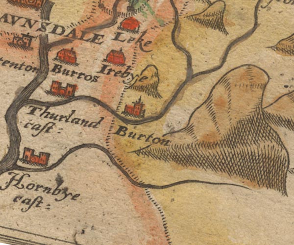 Sax9SD67.jpg Church, symbol for a parish or village, with a parish church. "Burton" item:- private collection : 2 Image © see bottom of page |
|
|
|
||
| evidence:- | old map:- Speed 1611 (Wmd) placename:- Burton |
|
| source data:- | Map, hand coloured engraving, The Countie Westmorland and
Kendale the Cheif Towne, scale about 2.5 miles to 1 inch, by
John Speed, 1610, published by George Humble, Popes Head Alley,
London, 1611-12.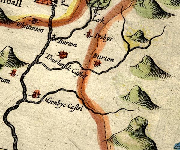 SP14SD67.jpg "Burton" circle, tower, Lancashire item:- Armitt Library : 2008.14.5 Image © see bottom of page |
|
|
|
||
| evidence:- | old map:- Jansson 1646 placename:- Burton |
|
| source data:- | Map, hand coloured engraving, Cumbria and Westmoria, ie
Cumberland and Westmorland, scale about 3.5 miles to 1 inch, by
John Jansson, Amsterdam, Netherlands, 1646.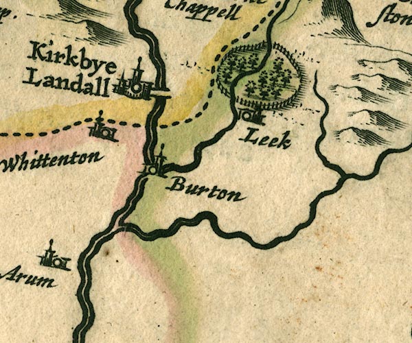 JAN3SD67.jpg "Burton" Buildings and tower. item:- JandMN : 88 Image © see bottom of page |
|
|
|
||
| evidence:- | old map:- Morden 1695 (Wmd) placename:- Burton |
|
| source data:- | Map, hand coloured engraving, Westmorland, scale about 2.5 miles to 1 inch, by Robert
Morden, published by Abel Swale, the Unicorn, St Paul's Churchyard, Awnsham, and John
Churchill, the Black Swan, Paternoster Row, London, 1695.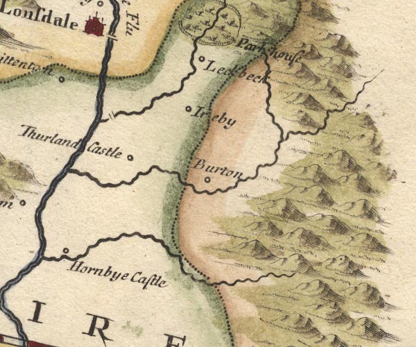 MD10SD67.jpg "Burton" Circle. item:- JandMN : 24 Image © see bottom of page |
|
|
|
||
| evidence:- | descriptive text:- West 1778 (11th edn 1821) |
|
| source data:- | Guide book, A Guide to the Lakes, by Thomas West, published by
William Pennington, Kendal, Cumbria once Westmorland, and in
London, 1778 to 1821. goto source goto sourceTour to the Caves in the West Riding of Yorkshire, late 18th century Page 243:- "..." "... Antoninus's tenth Itinerary runs from Glanoventa or Lanchester, in the county of Durham, ... to Glenovento or Draton, in the county of Salop. In various places by the side of this road are high artificial mounts of earth, which were without doubt the stations of centinels, to prevent any insurrections, or being surprised by an enemy: they may be now seen entire at Burton-in-Lons-" goto sourcePage 244:- "[Burton-in-Lons]dale, Overborough, Kirkby-Lonsdale, and Sedbergh. ..." "... Many of the smaller farmers, betwixt Kirkby-Lonsdale and Kendal, earn their bread with carrying coals, during most part of the year, from the pits at Ingleton, Black-Burton, or properly Burton-in-Lonsdale, to Kendal and the neighbouring places for fuel, and burning lime, in order to manure their land. These beds of coal, we were informed, are six or seven feet in thickness. A steam-engine was erected at Black-Burton, more commodiously to work their best collieries. A survey was lately subscribed for to be made, in order to have a canal from these pits to Lancaster, were (sic) coals might be exported; as also to Kendal and Settle, which are towns much in want of fuel. ..." goto sourcePage 250:- "..." "... Here [near Yordas Gill above Yordas Cave] was also a quarry of black marble, of which elegant monuments, chimney-pieces, slabs, and other pieces of furniture, are made by Mr. Tomlinson, at Burton-in-Lonsdale. When polished, this marble appears to be made up of entrochi, and various parts of testaceous and piscosous reliques." |
|
|
|
||
| evidence:- | old map:- Ford 1839 map placename:- Burton |
|
| source data:- | Map, uncoloured engraving, Map of the Lake District of
Cumberland, Westmoreland and Lancashire, scale about 3.5 miles
to 1 inch, published by Charles Thurnam, Carlisle, and by R
Groombridge, 5 Paternoster Row, London, 3rd edn 1843.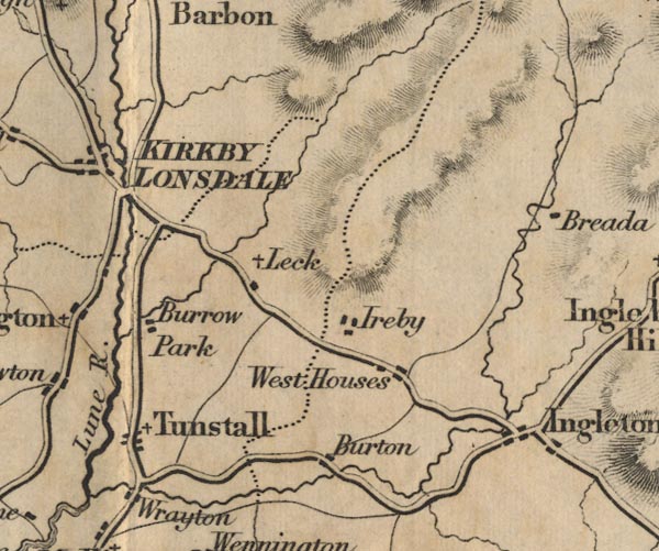 FD02SD67.jpg "Burton" item:- JandMN : 100.1 Image © see bottom of page |
|
|
|
||
| evidence:- | old map:- Garnett 1850s-60s H placename:- Black Burton |
|
| source data:- | Map of the English Lakes, in Cumberland, Westmorland and
Lancashire, scale about 3.5 miles to 1 inch, published by John
Garnett, Windermere, Westmorland, 1850s-60s.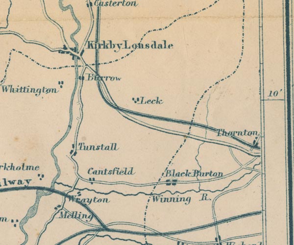 GAR2SD67.jpg "Black Burton" blocks, settlement item:- JandMN : 82.1 Image © see bottom of page |
|
|
|
||
Lakes Guides menu.