 Old Cumbria Gazetteer
 |
 |
|
| Bowness Knott, Ennerdale and Kinniside | ||
| Bowness Knott | ||
| locality:- | Ennerdale | |
| civil parish:- | Ennerdale and Kinniside (formerly Cumberland) | |
| county:- | Cumbria | |
| locality type:- | hill | |
| coordinates:- | NY11211554 | |
| 1Km square:- | NY1115 | |
| 10Km square:- | NY11 | |
| altitude:- | 1093 feet | |
| altitude:- | 333m | |
|
|
||
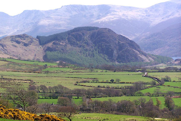 BMA07.jpg From Cauda Brow; with Forestry Commission trees. (taken 3.5.2006) 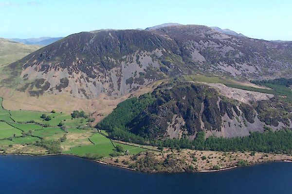 BUL69.jpg (taken 27.4.2011) |
||
|
|
||
| evidence:- | old map:- OS County Series (Cmd 68 12) placename:- Bowness Knott |
|
| source data:- | Maps, County Series maps of Great Britain, scales 6 and 25
inches to 1 mile, published by the Ordnance Survey, Southampton,
Hampshire, from about 1863 to 1948. |
|
|
|
||
| evidence:- | old text:- Green 1810 placename:- Bonus Knott |
|
| source data:- | Set of prints, soft ground etchings, Sixty Studies from Nature,
by William Green, Ambleside, Westmorland, drawn 1808-10,
published 1810. goto source goto sourcepage 72:- "[Ennerdale Water] ... Bonus Knot, a mountain mass of rugged rock, is the side screen on the left, ..." |
|
|
|
||
| evidence:- | old print:- Green 1814 (plate 42) placename:- Bonus Knott |
|
| source data:- | Print, tinted soft ground etching, Ennerdale Water, Ennerdale and Kinniside, Cumberland,
by William Green, Ambleside, Westmorland, 1814. click to enlarge click to enlargeGN1042.jpg Plate 42 in Sixty Small Prints. printed at top right:- "42" printed at bottom:- "ENNERDALE WATER. / Published at Ambleside Augst. 1, 1814, by Wm. Green." item:- Armitt Library : A6653.42 Image © see bottom of page |
|
|
|
||
| evidence:- | old print:- Green 1814 (plate 42) placename:- Bonus Knott |
|
| source data:- | Print, uncoloured soft ground etching, Ennerdale Water, Ennerdale and Kinniside, Cumberland,
by William Green, Ambleside, Westmorland, 1814.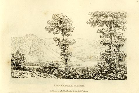 click to enlarge click to enlargeGN0942.jpg Plate 42 in Sixty Small Prints. printed at top right:- "42" printed at bottom:- "ENNERDALE WATER. / Published at Ambleside Augst. 1, 1814, by Wm. Green." item:- Armitt Library : A6656.42 Image © see bottom of page |
|
|
|
||
| evidence:- | old text:- Green 1814 placename:- Bonus Knott |
|
| source data:- | Set of prints, soft ground etchings, Sixty Small Prints, with
text, A Description of a Series of Sixty Small Prints, by
William Green, Ambleside, Westmorland, 1814. goto source page 23:- "... Bonus Knott, a mountain mass of rugged rock, is the side screen on the left [of Ennerdale Water] ..." |
|
|
|
||
| evidence:- | old print:- Fielding and Walton 1821 (plate 31) |
|
| source data:- | Print, coloured aquatint, Ennerdale Water, Ennerdale and Kinniside, Cumberland, drawn
by Theodore H A Fielding, published by R Ackermann, 101 Strand, London, 1821.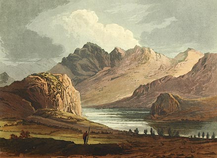 click to enlarge click to enlargeFW0131.jpg Bowness Knott and Angler's Crag are prominent. Tipped in opposite p.206 in A Picturesque Tour of the English Lakes. item:- Dove Cottage : 1993.R566.31 Image © see bottom of page |
|
|
|
||
| evidence:- | outline view:- Otley 1823 (8th edn 1849) placename:- Bowness Knot |
|
| source data:- | Engraving, outline view of mountains, Ennerdale from a Field near Kirkland and Salter,
drawn by T Binns, engraved by O Jewitt, opposite p.20 of A Descriptive Guide of the
English Lakes, by Jonathan Otley, 8th edition, 1849.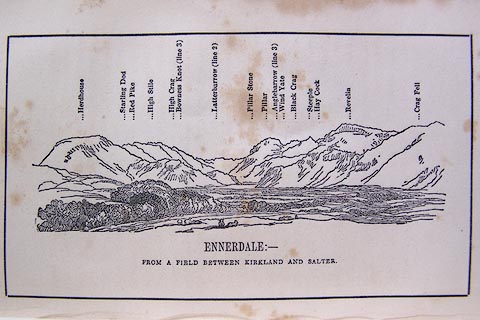 click to enlarge click to enlargeO80E11.jpg item:- Armitt Library : A1180.12 Image © see bottom of page |
|
|
|
||
| evidence:- | outline view:- Otley 1823 (5th edn 1834) placename:- Bowness Knot |
|
| source data:- | Print, woodcut outline view, The Mountains of Ennerdale, by
Jonathan Otley, Keswick, Cumberland, 1830.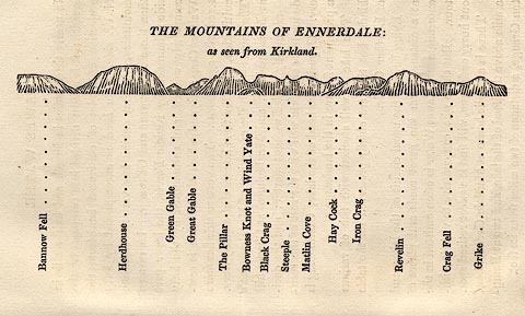 click to enlarge click to enlargeOT2E06.jpg Printed on p.27 of A Concise Description of the English Lakes, by Jonathan Otley, 5th edition, 1834. "THE MOUNTAINS OF ENNERDALE: as seen from Kirkland." "Bannow Fell / Herdhouse / Green Gable / Great Gable / The Pillar / Bowness Knot and Wind Yate / Black Crag / Steeple / Matlin Cove / Hay Cock / Iron Crag / Revelin / Crag Fell / Grike" item:- JandMN : 48.7 Image © see bottom of page |
|
|
|
||
| evidence:- | outline view:- Matthew 1866 placename:- Bowness Knott |
|
| source data:- | Print, engraving, outline view, Ennerdale, Cumberland, published by J Richardson,
Highgate, Kendal, Westmorland, 1866.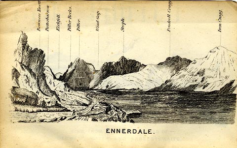 click to enlarge click to enlargeMW1E04.jpg Tipped in before p.1 of The English Lakes, Peaks and Passes, from Kendal to Keswick, by George King Matthew. printed at bottom:- "ENNERDALE" printed at caption to mountains:- "Bowness Knott. ..." item:- Armitt Library : A1168.4 Image © see bottom of page |
|
|
|
||
| evidence:- | outline view:- Tattersall 1836 (version 1869) |
|
| source data:- | Print, hand coloured, Ennerdale Lake, from the North East, Cumberland, drawn by George
Tattersall, 1836, engraved by W F Topham, published by T J Allman, 463 Oxford Street,
London, 1869.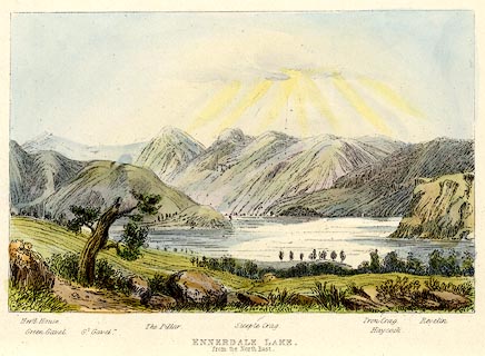 click to enlarge click to enlargeTAT215.jpg Included in The Lakes of England, by W F Topham. printed at bottom:- "ENNERDALE LAKE, / from the North East." printed at bottom:- "Herd House. / Green Gavel. / Gt. Gavel. / The Pillar. / Steeple Crag. / Iron Crag. / Haycock. / Revelin." item:- Armitt Library : A1067.15 Image © see bottom of page |
|
|
|
||
| evidence:- | outline view:- Tattersall 1836 |
|
| source data:- | Print, engraving, Ennerdale Lake, from the North East, Cumberland, drawn by George
Tattersall, engraved by W F Topham, published by Sherwood and Co, Paternoster Row,
London, about 1836.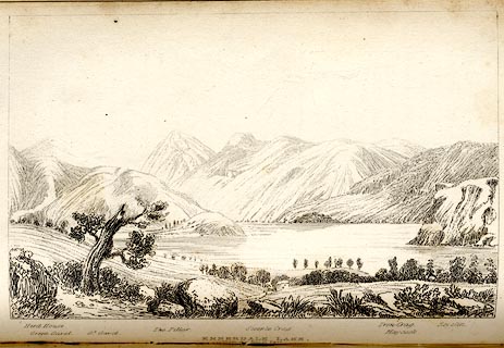 click to enlarge click to enlargeTAT133.jpg The print is captioned with mountain names and acts as an outline view. Tipped in opposite p.83 of The Lakes of England, by George Tattersall. printed at bottom:- "ENNERDALE LAKE, / from the North East." printed at bottom left to right:- "Herd House. / Green Gavel. / Gt. Gavel. / The Pillar. / Steeple Crag. / Iron Crag. / Haycock. / Revelin." item:- Armitt Library : A1204.34 Image © see bottom of page |
|
|
|
||
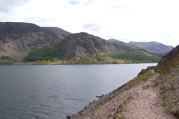 BWO10.jpg (taken 16.5.2012) |
||
|
|
||
| MN photo:- |
There is a useful car park at the foot of the knot. |
|
 CEE70.jpg (taken 27.10.2015) |
||
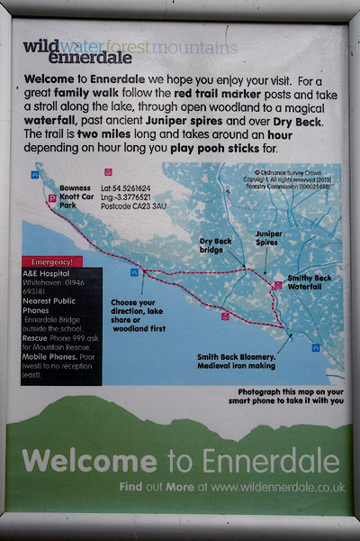
| Good useful data, especially for emergencies; BUT |
||
| Latitude and longitude with .0000001 degree accuracy, which is about +- 1cm |
||
| Post code, which, in a rural area, is +- half a mile. |
||
| No grid reference. |
||
|
|
||
Lakes Guides menu.