 Old Cumbria Gazetteer
 |
 |
|
| Birk Fell, Patterdale | ||
| Birk Fell | ||
| civil parish:- | Patterdale (formerly Westmorland) | |
| county:- | Cumbria | |
| locality type:- | hill | |
| locality type:- | fell | |
| coordinates:- | NY40261810 (etc) | |
| 1Km square:- | NY4018 | |
| 10Km square:- | NY41 | |
|
|
||
| evidence:- | old map:- OS County Series (Wmd 12 7) placename:- Birk Fell |
|
| source data:- | Maps, County Series maps of Great Britain, scales 6 and 25
inches to 1 mile, published by the Ordnance Survey, Southampton,
Hampshire, from about 1863 to 1948. |
|
|
|
||
| evidence:- | old text:- Clarke 1787 placename:- Birk Fell |
|
| source data:- | Guide book, A Survey of the Lakes of Cumberland, Westmorland,
and Lancashire, written and published by James Clarke, Penrith,
Cumberland, and in London etc, 1787; published 1787-93. goto source goto sourcePage 34:- "... failing (sic) under Pless-Fell take a view into Martindale. The first thing worth notice is the wall, almost opposite to Householm island [Norfolk Island], where Pless-Fell changes its name to Birk-Fell, (which it preserves as far as Sandwich Fields,) and where Martindale begins. ..." |
|
|
|
||
| evidence:- | old map:- Clarke 1787 map (Ullswater) placename:- Birk Fell |
|
| source data:- | Map, A Map of the Lake Ullswater and its Environs, scale about
6.5 ins to 1 mile, by James Clarke, engraved by S J Neele, 352
Strand, published by James Clarke, Penrith, Cumberland and in
London etc, 1787.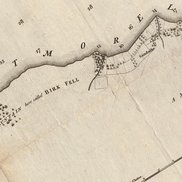 CL4NY41E.jpg "A MOUNTAIN here called BIRK FELL" item:- private collection : 10.4 Image © see bottom of page |
|
|
|
||
| evidence:- | outline view:- Otley 1823 (4th edn 1830) placename:- Birk Fell |
|
| source data:- | Print, engraving, outline view, The Mountains of Ullswater as seen from Pooley Bridge,
published by Jonathan Otley, Keswick, Cumberland et al, 1830.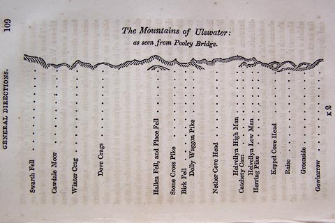 click to enlarge click to enlargeO75E05.jpg p.109 in A Concise Description of the English Lakes, by Jonathan Otley, 4th edition, 1830. "The Mountains of Ulswater: / as seen from Pooley Bridge." "Swarth Fell / Cawdale Moor / Winter Crag / Dove Crags / Hallen Fell, and Place Fell / Stone Cross Pike / Birk Fell / Dolly Waggon Pike / Nether Cove Head / Helvellyn High Man / Catchety Cam / Helvellyn Low Man / Herring Pike / Keppel Cove Head / Raise / Greenside / Gowbarrow" item:- Armitt Library : A1175.5 Image © see bottom of page |
|
|
|
||
| evidence:- | outline view:- Otley 1823 (8th edn 1849) placename:- Birk Fell |
|
| source data:- | Engraving, outline view of mountains, Ullswater from Pooley Bridge, drawn by T Binns,
engraved by O Jewitt, opposite p.12 of A Descriptive Guide of the English Lakes, by
Jonathan Otley, 8th edition, 1849.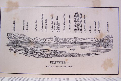 click to enlarge click to enlargeO80E07.jpg item:- Armitt Library : A1180.8 Image © see bottom of page |
|
|
|
||
| evidence:- | outline view:- Otley 1823 (5th edn 1834) |
|
| source data:- | Print, woodcut outline view, Mountains of Ullswater, by
Jonathan Otley, Keswick, Cumberland, 1830.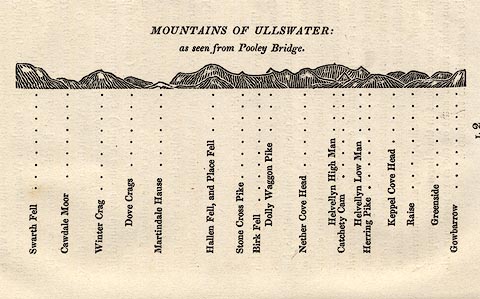 click to enlarge click to enlargeOT2E12.jpg Printed on p.113 of A Concise Description of the English Lakes, by Jonathan Otley, 5th edition, 1834. "MOUNTAINS OF ULLSWATER: as seen from Pooley Bridge." Mountains are listed:- "Swarth Fell / Cawdale Moor / Winter Crag / Dove Crags / Martindale Hause / Hallen Fell, and Place Fell / Stone Cross Pike / Birk Fell / Dolly Waggon Pike / Nether Cove Head / Helvellyn High Man / Catchety Cam / Helvellyn Low Man / Herring Pike / Keppel Cove Head / Raise / Greenside / Gowbarrow" item:- JandMN : 48.13 Image © see bottom of page |
|
|
|
||
| evidence:- | outline view:- Martineau 1855 |
|
| source data:- | Print, engraving, outline view, Mountains seen on the Keswick Road approaching Ullswater,
drawn by L Aspland, engraved by W Banks, Edinburgh, published by John Garnett, Windermere,
Westmorland, and by Whittaker and Co, London, 1855.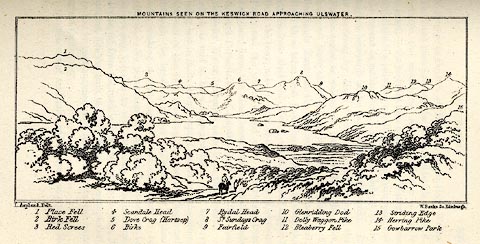 click to enlarge click to enlargeMNU115.jpg Plate opposite p.104 in A Complete Guide to the English Lakes, by Harriet Martineau. "MOUNTAINS SEEN ON THE KESWICK ROAD APPROACHING ULLSWATER." "L Aspland Delt. / W Banks Sc Edinr." The view is captioned, numbers referring to mountains in the image:- "1 Place Fell, 2 Birk Fell, 3 Red Screes, 4 Scandale Head, 5 Dove Crag (Hartsop), 6 Birks, 7 Rydal Head, 8 St. Sundays Crag, 9, Fairfield, 10 Glenridding Dod, 11 Dolly Waggon Pike, 12 Bleaberry Fell, 13 Striding Edge, 14 Herring Pike, 15 Gowbarrow Park." item:- Armitt Library : A1159.15 Image © see bottom of page |
|
|
|
||
| evidence:- | outline view:- Tattersall 1836 (version 1869) placename:- Birk Fell |
|
| source data:- | Print, hand coloured, Upper Reach, Ullswater, Westmorland, drawn by George Tattersall,
1836, engraved by W F Topham, published by T J Allman, 463 Oxford Street, London,
1869.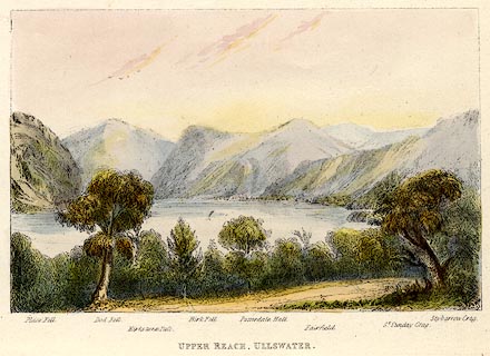 click to enlarge click to enlargeTAT218.jpg Included in The Lakes of England, by W F Topham. printed at bottom:- "UPPER REACH, ULLSWATER." printed at bottom:- "Place Fell. / Dod Fell. / Kirkstone Pass. / Birk Fell. / Patterdale Hall. / Fairfield. / St. Sunday Crag. / Stybarrow Crag." item:- Armitt Library : A1067.18 Image © see bottom of page |
|
|
|
||
| evidence:- | outline view:- Tattersall 1836 placename:- Birk Fell |
|
| source data:- | Print, engraving, Upper Reach, Ullswater, Westmorland, drawn by George Tattersall,
engraved by W F Topham, published by Sherwood and Co, Paternoster Row, London, about
1836.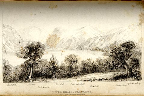 click to enlarge click to enlargeTAT142.jpg The print is captioned with mountain names and acts as an outline view. Tipped in opposite p.118 of The Lakes of England, by George Tattersall. printed at bottom:- "UPPER REACH, ULLSWATER. / [London Pubd. ...]" printed at bottom left to right:- "Place Fell. / Dod Fell. / Kirkstone Pass. / Birk Fell. / Patterdale Hall. / Fairfield. / St. Sunday Crag. / Stybarrow Crag." item:- Armitt Library : A1204.43 Image © see bottom of page |
|
|
|
||
Lakes Guides menu.