 Old Cumbria Gazetteer
 |
 |
|
| Allonby Bay, Solway Firth | ||
| Allonby Bay | ||
| locality:- | Solway Firth | |
| civil parish:- | Allonby (formerly Cumberland) | |
| civil parish:- | Hayton and Mealo (formerly Cumberland) | |
| civil parish:- | Oughterside and Allerby (formerly Cumberland) | |
| county:- | Cumbria | |
| locality type:- | bay | |
| coordinates:- | NY06854250 (etc) | |
| 1Km square:- | NY0642 | |
| 10Km square:- | NY04 | |
|
|
||
| evidence:- | old map:- OS County Series (Cmd 35 2) placename:- Allonby Bay |
|
| source data:- | Maps, County Series maps of Great Britain, scales 6 and 25
inches to 1 mile, published by the Ordnance Survey, Southampton,
Hampshire, from about 1863 to 1948. OS County Series (Cmd 35 10) OS County Series (Cmd 35 13) |
|
|
|
||
| evidence:- | old map:- Donald 1774 (Cmd) placename:- Allonby Bay |
|
| source data:- | Map, hand coloured engraving, 3x2 sheets, The County of Cumberland, scale about 1
inch to 1 mile, by Thomas Donald, engraved and published by Joseph Hodskinson, 29
Arundel Street, Strand, London, 1774.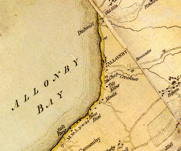 D4NY04SE.jpg "ALLONBY BAY" bay item:- Carlisle Library : Map 2 Image © Carlisle Library |
|
|
|
||
| evidence:- | old text:- Admiralty 1933 placename:- Allonby Bay item:- anchorage |
|
| source data:- |  goto source goto sourcePage 398:- "..." "... Allonby bay lies between Bankend point, situated three-quarters of a mile northward of Maryport, and Dubmill point, 4 3/4 miles farther northward." "The coast [at Allonby Bay] is low, backed by gradually rising ground. The low-water line is composed of loose stones, and the shelving foreshore, generally about 3 1/2 cables wide, consists of sand with patches of rock, afterwards becoming merged in Dubmill and Ellison scars, which dry out for a distance of about 2 1/4 miles offshore." "The southern portion of Allonby bay affords good anchorage for small craft, with offshore winds, in depths from 2 1/2 to 3 fathoms (4m6 to 5m5). When anchoring, Allonby church should not be brought to bear more than 083~, on account of foul ground northward of this line, which extends out from and skirts Dubmill scar. As stated at page 389 there is very little tidal stream in the bay after one-third ebb, owing to the uncovering of the flats which extend from Dubmill point at this time." |
|
|
|
||
Lakes Guides menu.