 Old Cumbria Gazetteer
 |
 |
|
| included in:- |
 Wads Howe, Longsleddale Wads Howe, Longsleddale |
|
| Wads Howe, Longsleddale: Corn Rent Act 1836 | ||
| evidence:- | tithe schedule:- Kendal Corn Rent Act 1836 placename:- Wads How |
|
| source data:- | Tithe map, Plan of part of the Township of Longsleddale, Westmorland, made regarding
the Kendal Corn Rent Act, ie a tithe award map, scale about 20 inches to 1 mile, Kendal,
Westmorland, 1836. Schedule, each row gives:- Field no. / Tenant's name / Close ie Field name / Type of culture / Area, acres Owned by Thomas Hudson jnr, tenanted by himself; Wads How. "/ / Hudson Thos. Junr." "/ 274 / Himself / New Close / Ar / 0 945" "/ 275a / Do / Rye Garths in dales / Ar &Mea / 3 000" "/ 275 / 24/253 pts Do or 12 Gaits / Sleddale Forest / Pas / 94 230" "/ 286 / Do / Little Rye Garths / Mea / 1 645" "/ 287 / Do / Acres / Mea / 5 495" "/ 288 / Do / Tween Giles / Ar &Mea / 3 110" "/ 289 / Do / Kiln How / Pas / 2 200" "/ 290 / Do / Homestead Lane &c at Wads Howe / / 0 795" "/ 291 / Do / Little Parrock / Pas / 1 290" "/ 292 / Do / Plantation / / 0 055" "/ 293 / Do / Wood / Pas / 26 675" "/ / / / / [total] 139 440" "" 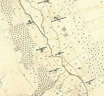 click to enlarge click to enlargeCRny4903.jpg map courtesy of Mark Cropper item:- private collection : 370 Image © see bottom of page |
|
|
|
||
| evidence:- | tithe awards:- Kendal Corn Rent Act 1836 placename:- Wads How |
|
| source data:- | Plan of the Township of Longsleddale, made for the Kendal Corn Rent Act, ie a tithe
award map, scale about 10 inches to 1 mile, Kendal, Westmorland, 1836. "Hudson Thomas Junr. / Himself / Wads How / 139 440 139 1 31 / ..." |
|
|
|
||
Lakes Guides menu.