 Old Cumbria Gazetteer
 |
 |
|
| Wood House, Longsleddale | ||
| Wood House | ||
| locality:- | Longsleddale | |
| civil parish:- | Longsleddale (formerly Westmorland) | |
| county:- | Cumbria | |
| locality type:- | buildings (gone) | |
| locality type:- | vicarage ? | |
| coordinates:- | NY50160280 | |
| 1Km square:- | NY5002 | |
| 10Km square:- | NY50 | |
| SummaryText:- | Vicarage rebuilt in 1886, now Capplebarrow House | |
|
|
||
| evidence:- | old map:- OS County Series (Wmd 27 15) placename:- Chapel House |
|
| source data:- | Maps, County Series maps of Great Britain, scales 6 and 25
inches to 1 mile, published by the Ordnance Survey, Southampton,
Hampshire, from about 1863 to 1948. |
|
|
|
||
| evidence:- | census returns:- placename:- Wood House |
|
|
|
||
 old parish registers (formerly ) old parish registers (formerly ) |
||
|
|
||
| evidence:- | old map:- Jefferys 1770 (Wmd) placename:- Wood House |
|
| source data:- | Map, 4 sheets, The County of Westmoreland, scale 1 inch to 1
mile, surveyed 1768, and engraved and published by Thomas
Jefferys, London, 1770.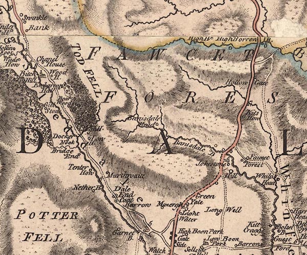 J5NY50SW.jpg "Wood H." circle, labelled in italic lowercase text; settlement, farm, house, or hamlet? item:- National Library of Scotland : EME.s.47 Image © National Library of Scotland |
|
|
|
||
| evidence:- | old map:- Cary 1789 (edn 1805) placename:- Wood House |
|
| source data:- | Map, uncoloured engraving, Westmoreland, scale about 2.5 miles
to 1 inch, by John Cary, London, 1789; edition 1805. CY24NY40.jpg "Wood Ho" block/s, labelled in italic lowercase; house, or hamlet item:- JandMN : 129 Image © see bottom of page |
|
|
|
||
| evidence:- | old map:- Hall 1820 (Wmd) placename:- Church House |
|
| source data:- | Map, hand coloured engraving, Westmoreland ie Westmorland, scale
about 14.5 miles to 1 inch, by Sidney Hall, London, 1820,
published by Samuel Leigh, 18 Strand, London, 1820-31. click to enlarge click to enlargeHA18.jpg "Church Ho." circle; house item:- Armitt Library : 2008.14.58 Image © see bottom of page |
|
|
|
||
| Kendal Corn Rent Act 1836 |
||
|
|
||
| evidence:- | old map:- OS 1881-82 New Series (outline edition) |
|
| source data:- | Map, engraving, area north of Kendal, Westmorland, New Series
one inch map, outline edition, sheet 39, scale 1 inch to 1 mile,
published by the Ordnance Survey, Southampton, Hampshire,
1881-82.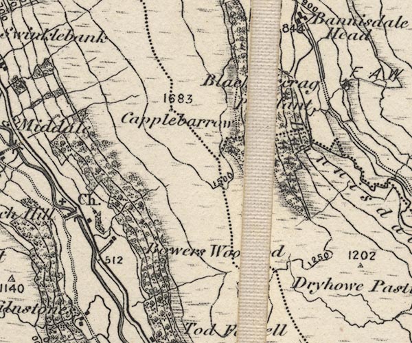 O21NY50B.jpg Not labelled. item:- JandMN : 61 Image © see bottom of page |
|
|
|
||
| census records |
||
|
|
||
| directory entries |
||
|
|
||
| evidence:- | possibly old newspaper:- K5703013.txt item:- inn, Longsleddale |
|
| source data:- | K5703013.txt Kendal Times Transcription from the Kendal Mercury 3 January 1857 page 3:- "..." "A certain man, resident in Bampton, being afflicted with a bad leg, which had been pronounced incurable by the regular practitioners, hearing of Dr. Lickbarrow's [17th century] wonderful fame, bethought himself of applying to him as a last resource. Accordingly, one fine morning he set out, accompanied by a friend to consult this celebrated personage, and having heard of the doctor's favourite propensity, he, upon his arrival at the Longsleddale alehouse, procured a bottle of the nut-brown, to take along with him as a sort of propitiatory to the great man's favour. Upon arriving at his residence [Murthwaite], ..." "[footnote] This valley then contained a place of public entertainment, but the place, in the march of modern improvement, has been converted into a parsonage-house, and there is now no public-house in the township." |
|
|
|
||
| see:- |  Capplebarrow House, Longsleddale Capplebarrow House, Longsleddale |
|
|
|
||
Lakes Guides menu.