 Old Cumbria Gazetteer
 |
 |
|
| Comb Gill (4) | ||
| Comb Gill | ||
| locality:- | Troutdale | |
| civil parish:- | Borrowdale (formerly Cumberland) | |
| county:- | Cumbria | |
| locality type:- | river | |
| 1Km square:- | NY2617 (etc) | |
| 10Km square:- | NY21 | |
|
|
||
| evidence:- | old map:- OS County Series (Cmd 70 2) placename:- Comb Gill |
|
| source data:- | Maps, County Series maps of Great Britain, scales 6 and 25
inches to 1 mile, published by the Ordnance Survey, Southampton,
Hampshire, from about 1863 to 1948. |
|
|
|
||
| evidence:- | old drawing:- Green 1790s-1820s (1807) placename:- Coum Gill |
|
| source data:- | Drawing, pencil, Waterfall on Coum Gill in Borrowdale, Cumberland, by William Green,
Ambleside, Westmorland, 16 August 1807.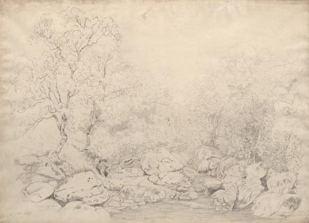 click to enlarge click to enlargePR1758.jpg ms, pencil at lower left, right:- "Augt 16 1807 / Water fall on Coum Gill in Borrowdale" item:- Dove Cottage : B45 Image © see bottom of page |
|
|
|
||
| evidence:- | old print:- Green 1810 (plate 44) placename:- Comb Gill item:- birch tree; tree |
|
| source data:- | Print, soft ground etching, Birch Trees in Coom Gill, probably Borrowdale, Cumberland,
by William Green, Ambleside, Westmorland, 1808.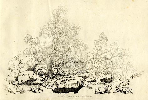 click to enlarge click to enlargeGN1244.jpg Plate 44 in Sixty Studies from Nature, 1810. printed at top right:- "44" printed at bottom:- "BIRCH TREES IN COOM GILL. / Drawn and Engraved by William Green, and Published at Ambleside, June 24, 1808." watermark:- "J WHATMAN / 1813" item:- Armitt Library : A6641.44 Image © see bottom of page |
|
|
|
||
 Lakes Guides menu.