 Old Cumbria Gazetteer
 |
 |
|
| bloomery, Torver | ||
| locality:- | Throng Moss | |
| locality:- | Torver Low Common | |
| civil parish:- | Torver (formerly Lancashire) | |
| county:- | Cumbria | |
| locality type:- | bloomery | |
| coordinates:- | SD27729233 (estimate) | |
| 1Km square:- | SD2792 | |
| 10Km square:- | SD29 | |
|
|
||
| evidence:- | old map:- OS County Series (Lan 4 15) |
|
| source data:- | Maps, County Series maps of Great Britain, scales 6 and 25
inches to 1 mile, published by the Ordnance Survey, Southampton,
Hampshire, from about 1863 to 1948. "ROMAN BLOOMARY (Site of)" |
|
|
|
||
| evidence:- | site plan:- Fell 1908 placename:- Throng Moss |
|
| source data:- | Site plan, Plan of Hearth at Throng Moss, Torver Low Common, Torver, Lancashire, published
by Hume Kitchin, 7 Market Street, Ulverston, Lancashire, 1908.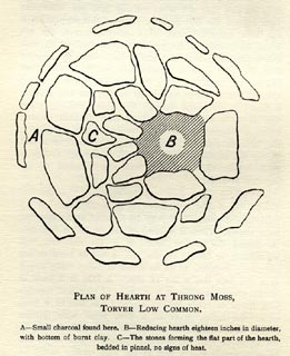 click to enlarge click to enlargeFLL102.jpg On p.168 of The Early Iron Industry of Furness and District, by Alfred Fell. printed, bottom "PLAN OF HEARTH AT THRONG MOSS, / TORVER LOW COMMON." item:- Armitt Library : A701.3 Image © see bottom of page |
|
|
|
||
 Lakes Guides menu.