 Old Cumbria Gazetteer
 |
 |
|
| Hilpsford Bank, Walney Island | ||
| Hilpsford Bank | ||
| locality:- | Walney Island | |
| locality:- | Irish Sea | |
| civil parish:- | Barrow-in-Furness (formerly Lancashire) (off) | |
| county:- | Cumbria | |
| locality type:- | sandbank | |
| coordinates:- | SD195610 (about, etc) | |
| 1Km square:- | SD1961 | |
| 10Km square:- | SD16 | |
|
|
||
| evidence:- | HO chart:- Hydrographic Office 1850s onwards placename:- Hilpsford Bank |
|
| source data:- | Chart, uncoloured engraving, England West Coast sheet XI,
Fleetwood to the Firth of Solway, scale about 2.5 miles to 1
inch, by H Denham and G Williams, 1846, engraved by J and C
Walker, published by the Hydrographic Office, 1850 corrected to
1863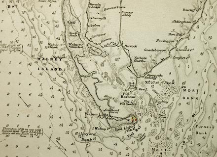 click to enlarge click to enlargeHY01P1.jpg "Hilpsford Bank" item:- Carlisle Library : Map 93 Image © Carlisle Library |
|
|
|
||
| evidence:- | old text:- Admiralty 1933 item:- buoy, Hilpsford; Hilpsford buoy |
|
| source data:- |  goto source goto sourcePage 378:- "A black can buoy, with a staff and cage topmark and marked "Hilpsford," is moored southward of Hilpsford shoal, which is situated at south-western corner of the bank, with depths of less than 2 fathoms (3m7) over it, that extends about 1 1/4 miles south-westward from Hilpsford point (Lat. 54~ 03' N., Long. 3~ 12' W.)." |
|
|
|
||
Lakes Guides menu.