 Old Cumbria Gazetteer
 |
 |
|
| Furness Bank, Morecambe Bay | ||
| Furness Bank | ||
| locality:- | Morecambe Bay | |
| civil parish:- | Lower Holker (formerly Lancashire) | |
| county:- | Cumbria | |
| locality type:- | sandbank | |
| coordinates:- | SD288619 (about, etc) | |
| 1Km square:- | SD2861 | |
| 10Km square:- | SD26 | |
|
|
||
| evidence:- | HO chart:- Hydrographic Office 1850s onwards placename:- Furness Bank |
|
| source data:- | Chart, uncoloured engraving, England West Coast sheet XI,
Fleetwood to the Firth of Solway, scale about 2.5 miles to 1
inch, by H Denham and G Williams, 1846, engraved by J and C
Walker, published by the Hydrographic Office, 1850 corrected to
1863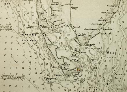 click to enlarge click to enlargeHY01P1.jpg "Furness Bank" item:- Carlisle Library : Map 93 Image © Carlisle Library |
|
|
|
||
| evidence:- | old text:- Admiralty 1933 placename:- Furness Bank |
|
| source data:- |  goto source goto sourcePage 375:- "..." "Ulverston channel. - Ulverston channel is a tortuous and shifting channel, formed by the outfall of the River Leven, passing westward of Bardsea bank, Cartmel Wharf, and Furness bank, and eastward of Mort bank and flat, which extends off the northern shore of Morecambe bay." |
|
|
|
||
Lakes Guides menu.