 Old Cumbria Gazetteer
 |
 |
|
| Kirkcambeck Church, Kirkcambeck | ||
| gone? | ||
| Kirkcambeck Church | ||
| locality:- | Kirkcambeck | |
| civil parish:- | Askerton (formerly Cumberland) | |
| county:- | Cumbria | |
| locality type:- | church | |
| coordinates:- | NY53376897 | |
| 1Km square:- | NY5368 | |
| 10Km square:- | NY56 | |
|
|
||
 BOX58.jpg (taken 29.3.2008) |
||
|
|
||
| evidence:- | old map:- OS County Series (Cmd 12 1) placename:- Kirkcambeck Church |
|
| source data:- | Maps, County Series maps of Great Britain, scales 6 and 25
inches to 1 mile, published by the Ordnance Survey, Southampton,
Hampshire, from about 1863 to 1948. "Kirkcambeck Church (Remains of)" |
|
|
|
||
| evidence:- | database:- Listed Buildings 2010 |
|
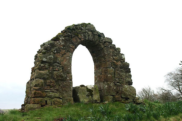
| source data:- | courtesy of English Heritage "ARCH EAST OF CHURCH OF ST KENTIGERN / / / ASKERTON / CARLISLE / CUMBRIA / II / 78115 / NY5337968970" |
|
| source data:- | courtesy of English Heritage "Arch from former church. Probably C13, rebuilt in C18. Moulded red sandstone. Single pointed arch built with materials from the medieval church. Church was destroyed in border raids in C14 and its exact position has not been established, but the present church of 1885 is thought to be on part of its site. See Transactions Cumberland & Westmorland Antiquarian &Archaeological Society, old series, xii, p88." |
|
|
|
||
| notes:- |
There was a church here in the 11th century. Only the doorway remains from this church,
which was destroyed by a Scots inroad in the 13th century. |
|
|
|
||
 Lakes Guides menu.