 Old Cumbria Gazetteer
 |
 |
|
| toll gate, Nether Denton | ||
| site name:- | road, Brampton to Haltwhistle | |
| locality:- | Low Row (near) | |
| civil parish:- | Nether Denton (formerly Cumberland) | |
| county:- | Cumbria | |
| locality type:- | buildings | |
| locality type:- | toll gate (site) | |
| locality type:- | toll house (ex) | |
| coordinates:- | NY58556263 | |
| 1Km square:- | NY5862 | |
| 10Km square:- | NY56 | |
|
|
||
| evidence:- | old map:- OS County Series (Cmd 18 3) |
|
| source data:- | Maps, County Series maps of Great Britain, scales 6 and 25
inches to 1 mile, published by the Ordnance Survey, Southampton,
Hampshire, from about 1863 to 1948. "T.P" gate across the road, and buildings |
|
|
|
||
| evidence:- | old map:- Donald 1774 (Cmd) |
|
| source data:- | Map, hand coloured engraving, 3x2 sheets, The County of Cumberland, scale about 1
inch to 1 mile, by Thomas Donald, engraved and published by Joseph Hodskinson, 29
Arundel Street, Strand, London, 1774.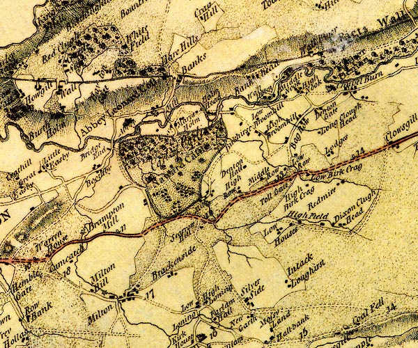 D4NY56SE.jpg "Toll Gate" building near Low Row, at mile 13 item:- Carlisle Library : Map 2 Image © Carlisle Library |
|
|
|
||
 Lakes Guides menu.