 Old Cumbria Gazetteer
 |
 |
|
| settlement, Hugill | ||
| civil parish:- | Hugill (formerly Westmorland) | |
| county:- | Cumbria | |
| locality type:- | british settlement | |
| coordinates:- | NY43730098 | |
| 1Km square:- | NY4300 | |
| 10Km square:- | NY40 | |
|
|
||
| evidence:- | site plan:- Historical Monuments 1936 |
|
| source data:- | Site plan, uncoloured lithograph, Settlement at Hugill, Westmorland, scale about 1
to 1300, published by Royal Commission on Historical Monuments England, London, 1936.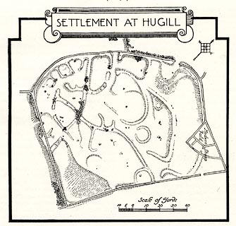 click to enlarge click to enlargeHMW075.jpg On p.115 of the Inventory of the Historical Monuments in Westmorland. printed, top "SETTLEMENT AT HUGILL" RCHME no. Wmd, Hugill 13 item:- Armitt Library : A745.75 Image © see bottom of page |
|
|
|
||
| notes:- |
Cup marked stones. |
|
| Becckensall, Stan: 2002: Prehistoric Rock Art in Cumbria: Tempus Publishing (Stroud,
Gloucestershire) |
||
|
|
||
 Lakes Guides menu.