 Old Cumbria Gazetteer
 |
 |
|
| Rowling End Farm, Above Derwent | ||
| Rowling End Farm | ||
| locality:- | Newlands Valley | |
| civil parish:- | Above Derwent (formerly Cumberland) | |
| county:- | Cumbria | |
| locality type:- | buildings | |
| coordinates:- | NY23462052 | |
| 1Km square:- | NY2320 | |
| 10Km square:- | NY22 | |
|
|
||
| evidence:- | old map:- OS County Series (Cmd 64 13) placename:- Low Houses placename:- Houses, Low |
|
| source data:- | Maps, County Series maps of Great Britain, scales 6 and 25
inches to 1 mile, published by the Ordnance Survey, Southampton,
Hampshire, from about 1863 to 1948. |
|
|
|
||
| evidence:- | old map:- Donald 1774 (Cmd) placename:- Low House |
|
| source data:- | Map, hand coloured engraving, 3x2 sheets, The County of Cumberland, scale about 1
inch to 1 mile, by Thomas Donald, engraved and published by Joseph Hodskinson, 29
Arundel Street, Strand, London, 1774.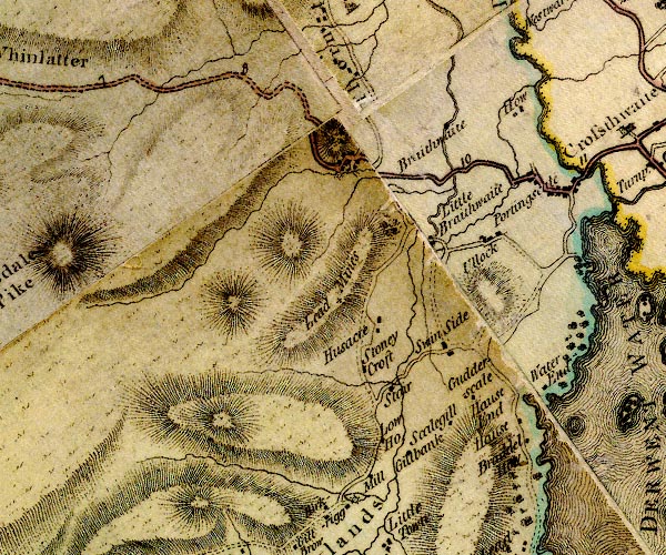 D4NY22SW.jpg "Low Ho." block or blocks, labelled in lowercase; a hamlet or just a house item:- Carlisle Library : Map 2 Image © Carlisle Library |
|
|
|
||
| evidence:- | old print:- Green 1809 placename:- Low Houses |
|
| source data:- | Print, soft ground etching, Low Houses in Newlands Valley, Cumberland, by William
Green, published by William Green, Ambleside, Westmorland, and Longman, Hurst, Rees
and Orme, Paternoster Row, London, 1809.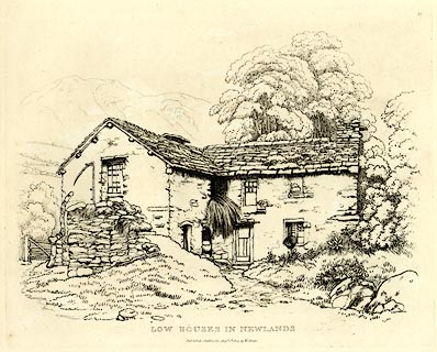 click to enlarge click to enlargeGN0337.jpg Plate 37 in Seventy Eight Studies from Nature. printed in introductory pages to set of prints:- "Number 37. The Horse Road between Keswick and Buttermere is through Newlands. Low Houses joins this road, and is about four miles from Keswick; Skelgill, with its Sycamores, is about half a mile to the left, and at right angles with the road at Low Houses." printed at bottom:- "LOW HOUSES IN NEWLANDS. / Published Ambleside, Augst. 1st. 1809, by W. Green." item:- Armitt Library : A6637.37 Image © see bottom of page |
|
|
|
||
 Lakes Guides menu.