 Old Cumbria Gazetteer
 |
 |
|
| Rothersyke, Lowside Quarter | ||
| Rothersyke | ||
| civil parish:- | Lowside Quarter (formerly Cumberland) | |
| county:- | Cumbria | |
| locality type:- | buildings | |
| coordinates:- | NY00350844 | |
| 1Km square:- | NY0008 | |
| 10Km square:- | NY00 | |
|
|
||
| evidence:- | old map:- OS County Series (Cmd 72 11) placename:- Rothersyke |
|
| source data:- | Maps, County Series maps of Great Britain, scales 6 and 25
inches to 1 mile, published by the Ordnance Survey, Southampton,
Hampshire, from about 1863 to 1948. |
|
|
|
||
| evidence:- | old map:- Donald 1774 (Cmd) placename:- Roder Sike |
|
| source data:- | Map, hand coloured engraving, 3x2 sheets, The County of Cumberland, scale about 1
inch to 1 mile, by Thomas Donald, engraved and published by Joseph Hodskinson, 29
Arundel Street, Strand, London, 1774.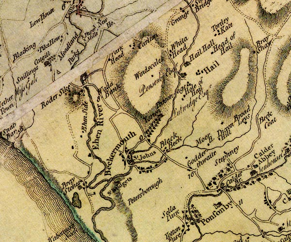 D4NY00NW.jpg "Roder Sike" block or blocks, labelled in lowercase; a hamlet or just a house item:- Carlisle Library : Map 2 Image © Carlisle Library |
|
|
|
||
| evidence:- | old text:- Gents Mag placename:- Rothersike Green item:- storm, 1806 |
|
| source data:- | Magazine, The Gentleman's Magazine or Monthly Intelligencer or
Historical Chronicle, published by Edward Cave under the
pseudonym Sylvanus Urban, and by other publishers, London,
monthly from 1731 to 1922. goto source goto sourceGentleman's Magazine 1806 p.576 "... At Whitehaven, about three P.M. some tremendous peals of thunder were heard, and considerable damage was done by the lightning. At Rothersike Green, in Low Quarter, in the parish of St. Bees, two heifers were killed; thirteen others close by received no injury. Several ash-trees were much damaged. ..." |
|
|
|
||
Lakes Guides menu.