 Old Cumbria Gazetteer
 |
 |
|
| roman camp, Nowtler Hill | ||
| locality:- | Nowtler Hill | |
| civil parish:- | Beaumont (formerly Cumberland) | |
| county:- | Cumbria | |
| locality type:- | roman camp | |
| coordinates:- | NY36295710 (about) | |
| 1Km square:- | NY3657 | |
| 10Km square:- | NY35 | |
|
|
||
| evidence:- | old map:- OS County Series (Cmd 23 2) |
|
| source data:- | Maps, County Series maps of Great Britain, scales 6 and 25
inches to 1 mile, published by the Ordnance Survey, Southampton,
Hampshire, from about 1863 to 1948. "CAMP (Remains of)" |
|
|
|
||
| evidence:- | old map:- Donald 1774 (Cmd) |
|
| source data:- | Map, hand coloured engraving, 3x2 sheets, The County of Cumberland, scale about 1
inch to 1 mile, by Thomas Donald, engraved and published by Joseph Hodskinson, 29
Arundel Street, Strand, London, 1774.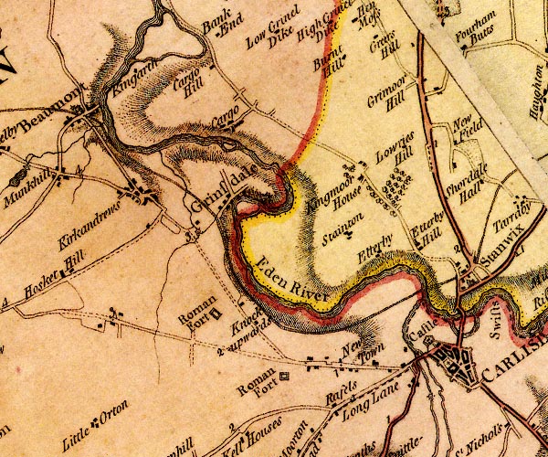 D4NY35NE.jpg "Roman Fort" square within a square; roman fort item:- Carlisle Library : Map 2 Image © Carlisle Library |
|
|
|
||
| evidence:- | old map:- Greenwood 1824 (Cmd) placename:- Far Camp |
|
| source data:- | Maps, Map of the County of Westmorland, scale about 1 inch to 1
mile, and Map of the County of Cumberland, scale about 1 inch to
1 mile, etc, by C and J Greenwood, published by George Pringle
jnr, 70 Queen Street, Cheapside, London, 1823 and 1824
respectively. |
|
|
|
||
 Lakes Guides menu.