 Old Cumbria Gazetteer
 |
 |
|
| Howgill Staith, Whitehaven Harbour | ||
| Howgill Staith | ||
| Street:- | West Strand | |
| locality:- | Old Quay | |
| locality:- | Whitehaven Harbour | |
| locality:- | Whitehaven | |
| civil parish:- | Whitehaven (formerly Cumberland) | |
| county:- | Cumbria | |
| locality type:- | coal staithes | |
| coordinates:- | NX96951824 (etc) | |
| 1Km square:- | NX9618 | |
| 10Km square:- | NX91 | |
|
|
||
| evidence:- | old map:- OS County Series (Cmd 67 2) placename:- Howgill Staith |
|
| source data:- | Maps, County Series maps of Great Britain, scales 6 and 25
inches to 1 mile, published by the Ordnance Survey, Southampton,
Hampshire, from about 1863 to 1948. |
|
|
|
||
| evidence:- | old map:- Donald 1774 (Cmd) item:- hurry |
|
| source data:- | Map, hand coloured engraving, 3x2 sheets, The County of Cumberland, scale about 1
inch to 1 mile, by Thomas Donald, engraved and published by Joseph Hodskinson, 29
Arundel Street, Strand, London, 1774.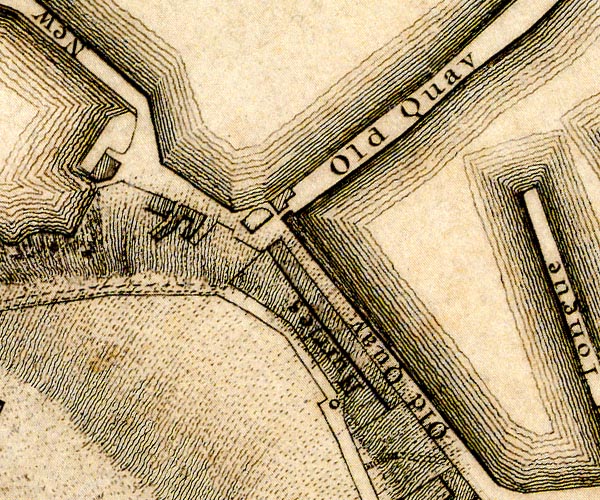 D49618W.jpg "Hurries" alongside Old Quay item:- Carlisle Library : Map 2 Image © Carlisle Library |
|
|
|
||
| hearsay:- |
The staith, or steer, had a platform 37 feet above high water, from here there were
5 spouts, called hurries. There was a store house floor 25 feet below. |
|
| Thomas Pennant described the staith, 1772:- |
||
| "Close to the shore, on the south side, is another [quay], covered with what is called here a steer, having in the lower part a range of smith's shops, and above an extensive floor capable of containing six thousand waggon loads of coal, of 4,200 lbs. each. But this is only used as a sort of magazine: for above this are galleries with rail roads, terminating in large flues, or hurries, placed sloping over the quay, and thro' these the coal is discharged out of the waggons into the holds of the ships, rolling down with a noise like thunder." |
||
| Lewis, M J T: 1970: Early Wooden Railways: Routlegde and Kegan Paul (London):: ISBN
0 7100 7818 8 |
||
|
|
||
 Lakes Guides menu.