 Old Cumbria Gazetteer
 |
 |
|
| South Pier, Maryport Harbour | ||
| South Pier | ||
| locality:- | Maryport Harbour | |
| locality:- | Maryport | |
| civil parish:- | Maryport (formerly Cumberland) | |
| county:- | Cumbria | |
| locality type:- | pier | |
| coordinates:- | NY02913685 (etc) | |
| 1Km square:- | NY0236 | |
| 10Km square:- | NY03 | |
|
|
||
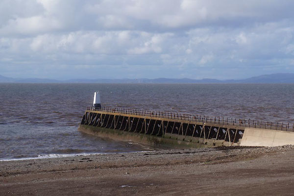 CFN91.jpg (taken 30.9.2016) |
||
|
|
||
| evidence:- | old map:- OS County Series (Cmd 44 8) placename:- South Pier |
|
| source data:- | Maps, County Series maps of Great Britain, scales 6 and 25
inches to 1 mile, published by the Ordnance Survey, Southampton,
Hampshire, from about 1863 to 1948. "South Pier / Light / Tide Ball / Lighthouse" |
|
|
|
||
| evidence:- | old text:- Admiralty 1933 placename:- South Pier item:- navigation lights; storm signal |
|
| source data:- |  goto source goto sourcePage 396:- "... A wooden breakwater, named South pier, projects about 600 feet (182m9) westward from the southern point of the entrance, and protects the entrance [to Maryport Harbour]." "..." "... A light is exhibited, at an elevation of 32 feet (9m8), from a white mast, 22 feet (6m7) in height, situated at the head of South pier" goto sourcePage 397:- "..." "A red ball is displayed from a flagstaff at the root of South pier, by day, or a white light is exhibited, at an elevation of 52 feet (15m9), from a white octagonal tower, 42 feet (12m8) in height, situated a short distance southward of the flagstaff, at night, when there are depths of 8 feet (2m4) or more in the harbour." "During tidal hours, namely from 2 1/2 hours before until 1 1/2 hours after high water, a green light is exhibited, at an elevation of 30 feet (9m1), from a white mast, 25 feet (7m6) in height, situated on the head of South jetty." "..." "Two red balls displayed from the flagstaff at the root of South pier, by day, or a red light exhibited 12 feet (3m7) below the above-mentioned white light, at night, denote that the channel is obstructed." goto sourcePage 398:- "..." "... Storm signals are displayed from a signal mast situated on the embankment near the root of South pier." |
|
|
|
||
Lakes Guides menu.