 Old Cumbria Gazetteer
 |
 |
|
| Lane, Troutbeck | ||
| suggested | ||
| Lane | ||
| locality:- | Troutbeck | |
| civil parish:- | Windermere (formerly Westmorland) | |
| county:- | Cumbria | |
| locality type:- | buildings | |
| coordinates:- | NY40720260 (guess) | |
| 1Km square:- | NY4002 | |
| 10Km square:- | NY40 | |
| references:- | Jefferys 1770 |
|
|
|
||
| evidence:- | old map:- Jefferys 1770 (Wmd) placename:- Lane |
|
| source data:- | Map, 4 sheets, The County of Westmoreland, scale 1 inch to 1
mile, surveyed 1768, and engraved and published by Thomas
Jefferys, London, 1770.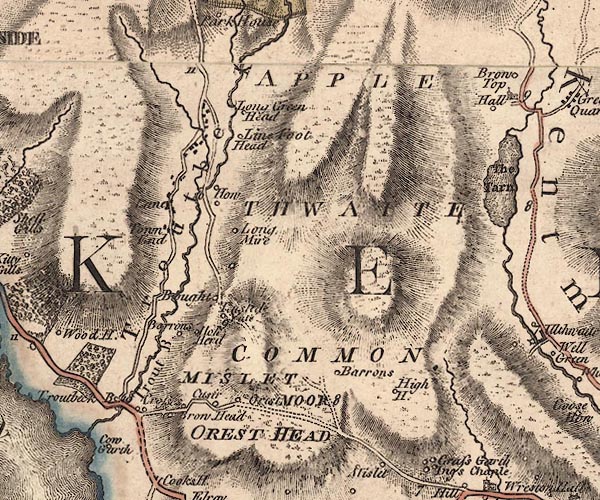 J5NY40SW.jpg "Lane" blocks, labelled in italic lowercase text; settlement, village? item:- National Library of Scotland : EME.s.47 Image © National Library of Scotland |
|
|
|
||
| evidence:- | old photograph:- Bell 1880s-1940s item:- costume; chimney |
|
| source data:- | Photograph, sepia, Lane House, Troutbeck, Westmorland, by Herbert Bell, photographer,
Ambleside, Westmorland, 1890s.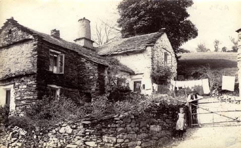 click to enlarge click to enlargeHB0753.jpg internegative at lower left:- "H. Bell" item:- Armitt Library : ALPS416 Image © see bottom of page |
|
|
|
||
 Lakes Guides menu.